


Mappa ferroviaria antica della Gran Bretagna di Tallis, 1850: Londra, Liverpool, Manchester, rotte dei battelli a vapore, bordi ornati

-
![]() Handmade in the USA
Handmade in the USA
-
FREE Christmas delivery in 3-4 days ⓘ
Free Christmas delivery in 3-4 days
Your map should be delivered in 3-4 working days with free delivery, worldwide.
We make maps by hand locally in 23 countries. If you're buying a gift for someone in another country, we will make the map locally to them.
You will never pay import tax or customs duty.
Check the Christmas delivery guide for order deadlines. Delivery times are starting to slow down, and will continue to slow down towards Christmas.
Express delivery is available at checkout which can reduce the delivery time to 1-2 days.
Please note that personalised maps, and larger framed maps, can take longer to produce and deliver.
If you need your order to arrive by a certain date, contact me and we can discuss your options.
-
90 day money back guarantee
ⓘ
90 giorni per restituire e ricevere un rimborso
I prodotti possono essere restituiti entro 90 giorni per un rimborso completo, o cambio con un altro prodotto.
Per articoli personalizzati e su misura, potremmo offrirti un credito in negozio o una carta regalo non scadente, poiché non possiamo rivendere ordini personalizzati.
Se hai domande, contattaci. Per ulteriori informazioni, consulta la nostra politica di restituzione e cambio.

My maps are rare, museum-grade, restored old maps sourced from libraries, auction houses and private collections across the globe.
Framing & free personalisation available
1. Select your size
2. Frame & personalize your map
There is limited framing & personalisation capacity available. Order by 10am tomorrow for Christmas delivery.


Gift message & custom finish

If you want to add a gift message, or a finish (jigsaw, aluminium board, etc.) that is not available here, please request it in the "order note" when you check out.
Every order is custom made, so if you need the size adjusted slightly, or printed on an unusual material, just let us know. We've done thousands of custom orders over the years, so there's (almost) nothing we can't manage.
You can also contact us before you order, if you prefer!

- Handmade locally. No import duty or tax
- FREE Delivery by Christmas
- Love it or your money back (90 days)
- Questions? WhatsApp me any time
Own a piece of history
5,000+ 5 star reviews


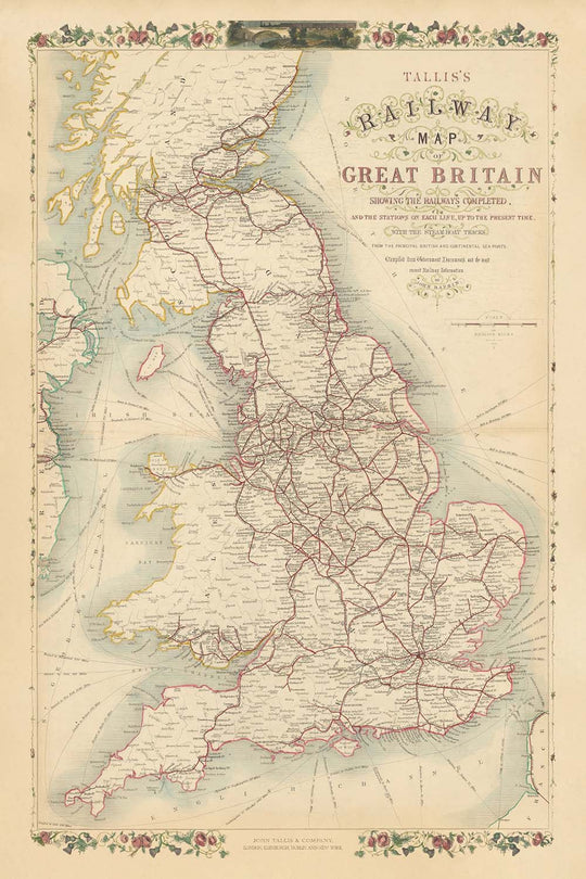
Entra nel mondo dinamico della Gran Bretagna vittoriana con "La mappa ferroviaria di Tallis della Gran Bretagna che mostra le ferrovie completate e le stazioni su ciascuna linea, fino al presente, con i percorsi dei battelli a vapore dai principali porti britannici e continentali." Realizzata nel 1850 dal celebre editore John Tallis e dall'abile incisore John Rapkin, questa mappa è una testimonianza del ritmo frenetico di innovazione e connettività dell'epoca. A colpo d'occhio, rivela l'intricata rete di ferrovie che ha trasformato il paesaggio, collegando le grandi città e i paesi dell'Inghilterra, della Scozia e del Galles durante il culmine della Rivoluzione Industriale.
John Tallis, rinomato per le sue opere cartografiche eleganti e decorative, ha infuso a questa mappa un senso di grandezza e chiarezza. Collaborando con John Rapkin, il cui incisore meticoloso ha dato vita ai dettagli, Tallis ha assicurato che ogni linea e stazione fosse non solo accurata—compilata con cura da documenti governativi e dalle ultime informazioni ferroviarie—ma anche visivamente affascinante. Il bordo ornato della mappa è bellissimo.
Il focus tematico della mappa sulle ferrovie e sui percorsi dei battelli a vapore racchiude i cambiamenti epocali della metà del XIX secolo. Le principali linee ferroviarie si irradiano da Londra, Birmingham, Manchester e Glasgow, collegando i centri industriali in espansione con i porti costieri e le campagne. I percorsi dei battelli a vapore si arcuano attraverso il Mare del Nord, la Manica e il Mare d'Irlanda, collegando i porti britannici all'Europa continentale e sottolineando la portata globale del commercio britannico. Ogni stazione ferroviaria e percorso è meticolosamente contrassegnato, offrendo un'istantanea di un paese in mezzo a una mobilità e a una trasformazione economica senza precedenti.
Oltre alle sue reti di trasporto, la mappa è una celebrazione della ricca e varia geografia della Gran Bretagna. Le colline ondulate del Galles, le aspre Highlands della Scozia e le fertili pianure dell'Inghilterra sono tutte suggerite in modo sottile, mentre i principali fiumi come il Tamigi, il Severn e il Clyde si fanno strada attraverso il paesaggio. Illustrazioni decorative evocano lo spirito dell'epoca: potenti ponti, porti affollati e la figura orgogliosa di Britannia, tutti ambientati contro uno sfondo di bellezza naturale e potenza industriale. I confini tra Inghilterra, Scozia e Galles sono chiaramente delineati, e i confini delle contee offrono ulteriori spunti sul paesaggio amministrativo dell'epoca.
Questa mappa è più di un aiuto alla navigazione; è un documento storico che cattura l'essenza di una nazione in movimento. Traccia l'ascesa di città come Londra, Birmingham, Liverpool e Glasgow—ora metropoli globali—e registra i nomi di paesi e regioni che hanno plasmato l'identità britannica per secoli. Che venga ammirata per la sua arte, il suo significato storico o la sua pura ambizione, questa mappa invita lo spettatore a tornare a un momento cruciale nella storia della Gran Bretagna, quando le rotaie di ferro e la potenza del vapore ridefinirono i contorni della vita quotidiana.
Città e paesi su questa mappa
-
Inghilterra
- Londra
- Birmingham
- Manchester
- Liverpool
- Leeds
- Sheffield
- Newcastle (Newcastle upon Tyne)
- Bristol
- Nottingham
- Leicester
- Portsmouth
- Southampton
- Derby
- York
- Norwich
- Exeter
- Carlisle
- Plymouth
- Hull (Kingston upon Hull)
- Sunderland
- Wolverhampton
- Stoke (Stoke-on-Trent)
- Preston
- Lancaster
- Chester
- Bath
- Oxford
- Cambridge
- Brighton
-
Scozia
- Glasgow
- Edimburgo
- Aberdeen
- Dundee
- Inverness
- Perth
- Stirling
-
Galles
- Cardiff
- Swansea
- Newport
- Bangor
- Wrexham
Caratteristiche e monumenti notevoli
- Bordo decorativo: Bordo ornato, floreale e a motivi che incornicia la mappa, tipico delle pubblicazioni di Tallis
- Corpi idrici:
- Il Mare del Nord (etichettato come Oceano Tedesco)
- La Manica
- Il Mare d'Irlanda
- Vari estuari e fiordi (es. Firth of Forth, Solway Firth)
- Confini:
- Confini chiaramente delineati tra Inghilterra, Scozia e Galles
- Confini delle contee all'interno di ciascun paese
- Tracce di battelli a vapore: Linee tratteggiate o evidenziate attraverso il mare, che collegano i porti britannici a destinazioni continentali
- Ferrovie: Linee ferroviarie marcate in modo prominente che si incrociano nel paese, con le stazioni indicate
- Montagne e terreno: Terreno collinare e montagnoso indicato, specialmente in Scozia e Galles, sebbene stilizzato piuttosto che topograficamente preciso
- I principali fiumi (es. Tamigi, Severn, Mersey, Clyde) sono etichettati
Contesto storico e di design
- Creato nel 1850, durante il culmine della Rivoluzione Industriale
- Pubblicato da John Tallis, un rinomato editore del 19° secolo noto per mappe eleganti e decorative
- Cartografia di John Rapkin, un abile incisore e frequente collaboratore di Tallis
- Focus tematico sulle infrastrutture ferroviarie e sulle rotte dei battelli a vapore, riflettendo la rapida trasformazione industriale e socio-economica della Gran Bretagna
- Meticolosamente compilato da documenti governativi e dalle ultime informazioni ferroviarie dell'epoca
- Cattura l'espansione delle ferrovie britanniche e l'aumento della mobilità nazionale
- Bordi decorativi e illustrazioni incise migliorano sia l'appeal visivo che il valore storico
- Serve come fonte primaria per comprendere il trasporto e la geografia britannica della metà del 19° secolo
- Offre un'idea del paesaggio amministrativo con confini di contea chiaramente marcati
Si prega di controllare attentamente le immagini per assicurarsi che una specifica città o luogo sia mostrato su questa mappa. Puoi anche contattarci e chiedere di controllare la mappa per te.
Questa mappa appare ottima in ogni dimensione, ma consiglio sempre di optare per una dimensione più grande se hai spazio. In questo modo puoi facilmente distinguere tutti i dettagli.
Questa mappa appare straordinaria in dimensioni fino a 90in (230cm). Se stai cercando una mappa più grande, per favore contattaci.
Si prega di notare: le etichette su questa mappa sono difficili da leggere se ordini una mappa che è 16in (40cm) o più piccola. La mappa è comunque molto attraente, ma se desideri leggere facilmente la mappa, ti preghiamo di acquistare una dimensione più grande.
Il modello nelle immagini dell'elenco tiene la versione di questa mappa da 24x36in (60x90cm).
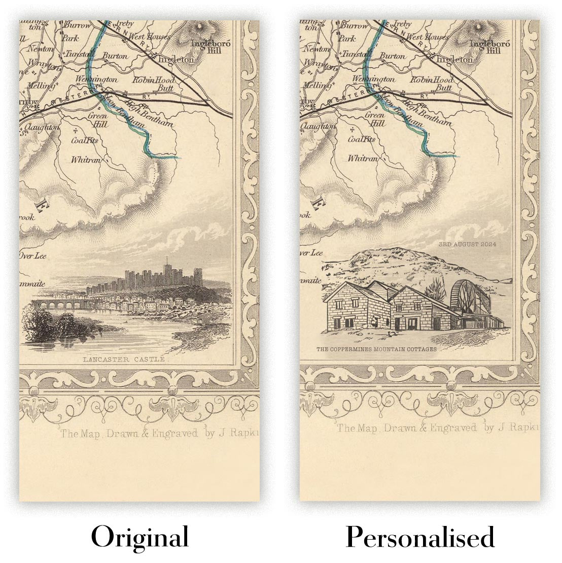
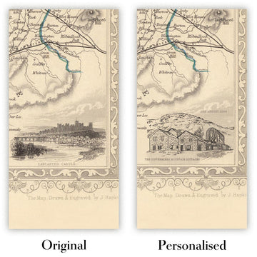
La quinta immagine dell'elenco mostra un esempio del mio servizio di personalizzazione della mappa.
Se stai cercando qualcosa di leggermente diverso, dai un'occhiata alla mia collezione delle migliori mappe antiche per vedere se qualcosa cattura la tua attenzione.
Per favore contattami per verificare se una certa località, punto di riferimento o caratteristica è mostrata su questa mappa.
Questo sarebbe un meraviglioso regalo per un compleanno, Natale, Festa del Papà, addio al lavoro, anniversario o per una casa nuova per qualcuno delle aree coperte da questa mappa.
Questa mappa è disponibile come stampa giclée su carta opaca archiviabile senza acidi, oppure puoi acquistarla incorniciata. La cornice è una semplice cornice nera che si adatta alla maggior parte degli stili. Ti preghiamo di contattarci se desideri un colore o un materiale diverso per la cornice. Le mie cornici sono dotate di un vetro acrilico super chiaro di grado museale (perspex/acrylite), che è significativamente meno riflettente del vetro, più sicuro e arriverà sempre in perfette condizioni.
This map is also available as a float framed canvas, sometimes known as a shadow gap framed canvas or canvas floater. The map is printed on artist's cotton canvas and then stretched over a handmade box frame. We then "float" the canvas inside a wooden frame, which is available in a range of colours (black, dark brown, oak, antique gold and white). This is a wonderful way to present a map without glazing in front. See some examples of float framed canvas maps and explore the differences between my different finishes.
For something truly unique, this map is also available in "Unique 3D", our trademarked process that dramatically transforms the map so that it has a wonderful sense of depth. We combine the original map with detailed topography and elevation data, so that mountains and the terrain really "pop". For more info and examples of 3D maps, check my Unique 3D page.
For most orders, delivery time is about 3 working days. Personalised and customised products take longer, as I have to do the personalisation and send it to you for approval, which usually takes 1 or 2 days.
Please note that very large framed orders usually take longer to make and deliver.
If you need your order to arrive by a certain date, please contact me before you order so that we can find the best way of making sure you get your order in time.
I print and frame maps and artwork in 23 countries around the world. This means your order will be made locally, which cuts down on delivery time and ensures that it won't be damaged during delivery. You'll never pay customs or import duty, and we'll put less CO2 into the air.
All of my maps and art prints are well packaged and sent in a rugged tube if unframed, or surrounded by foam if framed.
I try to send out all orders within 1 or 2 days of receiving your order, though some products (like face masks, mugs and tote bags) can take longer to make.
If you select Express Delivery at checkout your order we will prioritise your order and send it out by 1-day courier (Fedex, DHL, UPS, Parcelforce).
Next Day delivery is also available in some countries (US, UK, Singapore, UAE) but please try to order early in the day so that we can get it sent out on time.
My standard frame is a gallery style black ash hardwood frame. It is simple and quite modern looking. My standard frame is around 20mm (0.8in) wide.
I use super-clear acrylic (perspex/acrylite) for the frame glass. It's lighter and safer than glass - and it looks better, as the reflectivity is lower.
Six standard frame colours are available for free (black, dark brown, dark grey, oak, white and antique gold). Custom framing and mounting/matting is available if you're looking for something else.
Most maps, art and illustrations are also available as a framed canvas. We use matte (not shiny) cotton canvas, stretch it over a sustainably sourced box wood frame, and then 'float' the piece within a wood frame. The end result is quite beautiful, and there's no glazing to get in the way.
All frames are provided "ready to hang", with either a string or brackets on the back. Very large frames will have heavy duty hanging plates and/or a mounting baton. If you have any questions, please get in touch.
See some examples of my framed maps and framed canvas maps.
Alternatively, I can also supply old maps and artwork on canvas, foam board, cotton rag and other materials.
If you want to frame your map or artwork yourself, please read my size guide first.
Alcune delle mie vecchie mappe sono ora disponibili come tele incorniciate. Per favore contattami se desideri ordinare una dimensione che non è disponibile nel mio negozio.
Le vecchie mappe su tela sono un'alternativa interessante alle mappe incorniciate in modo convenzionale. A seconda del tuo gusto personale e dell'arredamento della stanza, le mappe su tela possono "risaltare" un po' di più rispetto a una mappa incorniciata.
My maps are extremely high quality reproductions of original maps.
I source original, rare maps from libraries, auction houses and private collections around the world, restore them at my London workshop, and then use specialist giclée inks and printers to create beautiful maps that look even better than the original.
My maps are printed on acid-free archival matte (not glossy) paper that feels very high quality and almost like card. In technical terms the paper weight/thickness is 10mil/200gsm. It's perfect for framing.
I print with Epson ultrachrome giclée UV fade resistant pigment inks - some of the best inks you can find.
I can also make maps on canvas, cotton rag and other exotic materials.
Learn more about The Unique Maps Co.
Map personalisation
If you're looking for the perfect anniversary or housewarming gift, I can personalise your map to make it truly unique. For example, I can add a short message, or highlight an important location, or add your family's coat of arms.
The options are almost infinite. Please see my map personalisation page for some wonderful examples of what's possible.
To order a personalised map, select "personalise your map" before adding it to your basket.
Get in touch if you're looking for more complex customisations and personalisations.
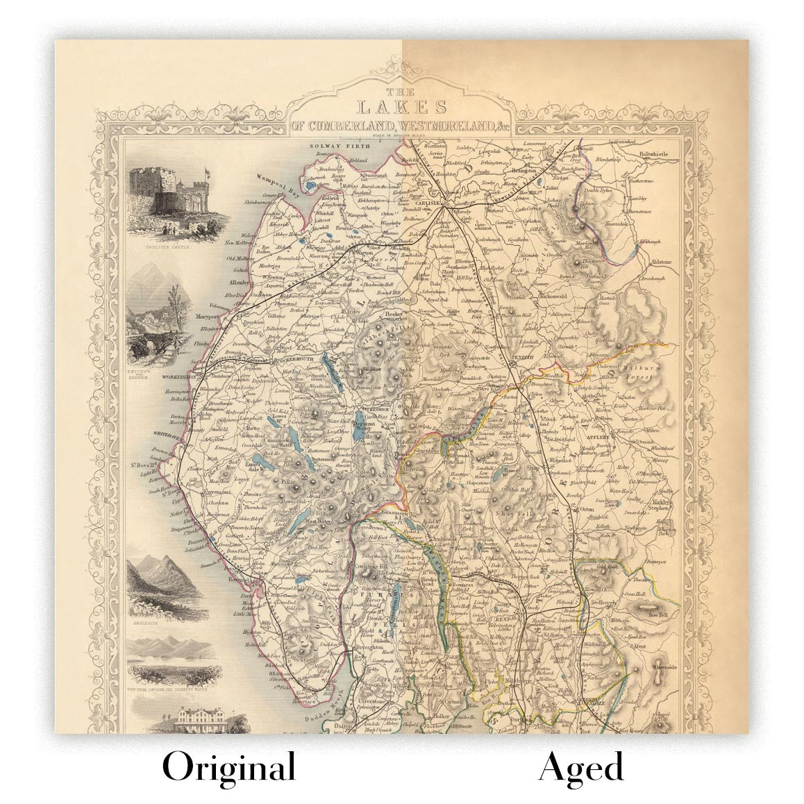
Map ageing
I have been asked hundreds of times over the years by customers if they could buy a map that looks even older.
Well, now you can, by selecting Aged before you add a map to your basket.
All the product photos you see on this page show the map in its Original form. This is what the map looks like today.
If you select Aged, I will age your map by hand, using a special and unique process developed through years of studying old maps, talking to researchers to understand the chemistry of aging paper, and of course... lots of practice!
If you're unsure, stick to the Original colour of the map. If you want something a bit darker and older looking, go for Aged.
Se non sei soddisfatto del tuo ordine per qualsiasi motivo, contattami per un rimborso senza problemi. Si prega di consultare la nostra politica di reso e rimborso per ulteriori informazioni.
Sono molto sicuro che ti piacerà la tua mappa restaurata o la stampa d'arte. Lo faccio dal 1984. Sono un venditore Etsy a 5 stelle. Ho venduto decine di migliaia di mappe e stampe d'arte e ho oltre 5.000 recensioni reali a 5 stelle.
Utilizzo un processo unico per restaurare mappe e opere d'arte che richiede molto tempo e lavoro. Trovare le mappe e le illustrazioni originali può richiedere mesi. Utilizzo tecnologia all'avanguardia e incredibilmente costosa per scannerizzare e restaurarle. Di conseguenza, garantisco che le mie mappe e stampe d'arte siano superiori alle altre - ecco perché posso offrire un rimborso senza problemi.
Quasi tutte le mie mappe e stampe d'arte sembrano fantastiche a grandi dimensioni (200 cm, 6,5 piedi+) e posso anche incorniciarle e consegnarle a te, tramite un corriere speciale per oggetti di grandi dimensioni. Contattami per discutere delle tue esigenze specifiche.
Or try searching for something!


