


Mappa dell'occhio d'uccello di Brooklyn di Bornet, 1855: Cantiere navale, Brooklyn Heights, DUMBO, Williamsburg, Lower Manhattan
Compra 2, Ricevi 1 Gratuito
Se aggiungi 2 articoli al tuo carrello, puoi aggiungere un terzo prodotto gratuitamente.
Questo vale per tutte le mappe e opere d'arte, comprese le opere personalizzate e su misura. Puoi ordinare 3 dello stesso articolo, o 3 articoli diversi.
Questo equivale a uno sconto del 33%, che sarà il maggiore sconto disponibile nel mio negozio quest'anno.
Ti prego di approfittare dell'offerta e di coprire le tue pareti con bellissime mappe e opere d'arte!
Contattami se hai domande.
-
![]() Handmade in the USA
Handmade in the USA

-
FREE worldwide delivery in 2-3 days ⓘ
Free delivery in 2-3 days
Your map should be delivered in 2-3 working days with free delivery, worldwide.
We make maps by hand locally in 23 countries. If you're buying a gift for someone in another country, we will make the map locally to them.
You will never pay import tax or customs duty.
Express delivery is available at checkout which can reduce the delivery time to 1-2 days.
Please note that personalised maps, and larger framed maps, can take longer to produce and deliver.
If you need your order to arrive by a certain date, contact me and we can discuss your options.
-
Complimentary gifting & design advice
ⓘ
Complimentary gifting & design advice
Available almost 24/7 on WhatsApp and email — we usually reply within minutes. We can help you:
- Choose a perfectly personalised gift
- Send a digital gift preview to the recipient
- Pick the ideal size for your wall
- Select the right finish and frame
Quick, friendly advice so you can order with confidence.
For last minute gifts, consider buying a digital gift card. We have over 5,000 maps and art prints to choose from.
-
90-day returns & 5-year guarantee
ⓘ
90 giorni per restituire e ricevere un rimborso
I prodotti possono essere restituiti entro 90 giorni per un rimborso completo, o cambio con un altro prodotto.
Per articoli personalizzati e su misura, potremmo offrirti un credito in negozio o una carta regalo non scadente, poiché non possiamo rivendere ordini personalizzati.
Se hai domande, contattaci. Per ulteriori informazioni, consulta la nostra politica di restituzione e cambio.

This is a museum-grade archival print from the original 1855 map — restored in our workshop and made to order on 220gsm archival matte paper or 400gsm artist's cotton canvas with pigment inks.
Professional framing & free personalisation available.
1. Choose a size
2. Frame & personalize your map
Make your map unique with framing, hand-drawn customisation, vintage ageing, pop art text, unique 3D styling and more.


Gift message & custom finish

If you want to add a gift message, or a finish (jigsaw, aluminium board, etc.) that is not available here, please request it in the "order note" when you check out.
Every order is custom made, so if you need the size adjusted slightly, or printed on an unusual material, just let us know. We've done thousands of custom orders over the years, so there's (almost) nothing we can't manage.
You can also contact us before you order, if you prefer!

- Handmade locally. No import duty or tax
- FREE worldwide delivery
- 90-day returns & 5-year product guarantee
- Questions? WhatsApp me any time
Own a piece of history
7,000+ 5 star reviews


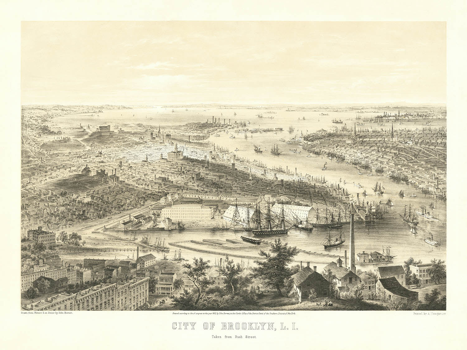
Entra nel mondo dinamico della New York di metà Ottocento con “City of Brooklyn, L.I. Taken from Rush Street,” una rara e suggestiva vista a volo d'uccello realizzata dall'acclamato artista e litografo John Bornet nel 1855. Questa mappa straordinaria cattura Brooklyn in un momento di trasformazione, pronto tra le sue radici pastorali e un futuro industriale in espansione. Il punto di vista da Williamsburg si estende a sud-est attraverso il Brooklyn Naval Yard, offrendo un tableau panoramico che comprende non solo i quartieri di Brooklyn Heights e DUMBO, ma anche lo skyline iconico di Lower Manhattan che brilla attraverso l'East River.
Ciò che rende questa mappa della città particolarmente affascinante è la sua fusione senza soluzione di continuità tra la tranquillità semi-rurale e l'ambizione urbana. In primo piano, si trovano scene evocative di fattorie e terreni aperti—reliquie del passato agrario di Brooklyn—mentre poco oltre, il polso della città accelera con densi gruppi di magazzini, moli affollati e la presenza imponente del Brooklyn Naval Yard. Qui, grandi navi da guerra ancorano la scena, sottolineando l'importanza strategica ed economica dell'area durante un periodo di crescita nazionale e potenza marittima.
L'arte di Bornet è evidente in ogni dettaglio, dalla meticolosa rappresentazione degli edifici individuali alla vivace raffigurazione di navi e commercio lungo l'East River. La prospettiva della mappa non solo offre una vista completa dei quartieri di Brooklyn—come l'elegante Brooklyn Heights e il laborioso lungomare di DUMBO—ma evidenzia anche la rete intricata di strade che presto definirà il tessuto urbano del quartiere. Viali notevoli come Fulton Street, Myrtle Avenue e Washington Street sono chiaramente etichettati, fornendo un affascinante istantanea della geografia in evoluzione della città.
Questa mappa si erge come un testamento alla rapida trasformazione di Brooklyn durante gli anni '50 dell'Ottocento, un decennio in cui la città stava espandendo sia la popolazione che la potenza economica. La presenza di punti di riferimento significativi, come il Brooklyn Naval Yard, insieme al traffico fluviale vivace, illustra l'identità duplice della città come centro industriale e porta verso il mondo più ampio. L'inclusione attenta di Lower Manhattan in lontananza serve come un toccante promemoria dei legami stretti tra questi due giganti urbani, anche prima della costruzione del Brooklyn Bridge.
John Bornet, l'artista dietro questa vista, era rinomato per la sua abilità nel catturare lo spirito dei paesaggi urbani di New York. Il suo doppio ruolo di artista e litografo garantì che ogni elemento della mappa—dalla delicata ombreggiatura delle periferie semi-rurali alla precisione architettonica dei blocchi urbani—fosse reso con chiarezza eccezionale e fedeltà storica. Oggi, questa mappa è celebrata non solo per la sua rarità ma anche per la sua vivida rappresentazione di una città sull'orlo della modernità, rendendola un'aggiunta preziosa per collezionisti e appassionati di storia.
Strade e vie in questa mappa
- Adams St.
- Atlantic St.
- Bridge St.
- Clinton Ave.
- Clinton St.
- Concord St.
- Court St.
- Cumberland St.
- DeKalb Ave.
- Duffield St.
- Flushing Ave.
- Franklin Ave.
- Fulton Ave.
- Fulton St.
- Gold St.
- Hicks St.
- Hudson Ave.
- Jay St.
- Lafayette Ave.
- Main St.
- Myrtle Ave.
- Nassau St.
- Navy St.
- Pacific St.
- Pearl St.
- Portland Ave.
- Rush St.
- Sands St.
- Tillary St.
- Washington St.
Caratteristiche e punti di riferimento notevoli
- Brooklyn Naval Yard (chiaramente rappresentato con grandi navi da guerra)
- Skyline di Lower Manhattan (visibile sullo sfondo)
- Numerose navi a vela e navi a vapore nell'East River
- Brooklyn Heights
- Williamsburg
- DUMBO (area vicino al lungomare)
- Fattoria semi-rurale e edifici agricoli in primo piano
- Edifici industriali e magazzini vicino al lungomare
- Rappresentazione dettagliata di navi e attività marittima nell'East River
Contesto storico e di design
- Nome della mappa: Città di Brooklyn, L.I. Presa da Rush Street
- Data di creazione: 1855
- Cartografo e editore: John Bornet, un abile creatore di vedute di New York che era sia l'artista originale che il litografo di questa mappa
- Prospettiva e punto di vista: Vista a volo d'uccello da Williamsburg, guardando a sud-est sul Brooklyn Naval Yard verso Brooklyn Heights, DUMBO e Lower Manhattan
- Copertura geografica: Rappresenta principalmente Brooklyn (inclusi Brooklyn Heights, DUMBO, Williamsburg e il Brooklyn Naval Yard) e Lower Manhattan, New York City, Stati Uniti
- Stile e design: Vista a volo d'uccello litografata a due pietre, uno stile popolare a metà del XIX secolo, che enfatizza illustrazioni dettagliate di edifici, navi e paesaggi urbani
- Temi e argomenti: Sviluppo urbano, industrializzazione, commercio, attività marittima e vita semi-rurale nella Brooklyn di metà '800
- Importanza storica: Fornisce un raro documento visivo di Brooklyn e Lower Manhattan durante un periodo di rapida crescita e transizione da paesaggi rurali a urbani-industriali. La presenza di grandi navi da guerra sottolinea l'importanza strategica ed economica del Brooklyn Naval Yard all'epoca
- Rarità: Questa mappa è considerata molto rara, con esemplari noti detenuti da prestigiose istituzioni come la New York Public Library, il Museum of the City of New York e la Yale Art Gallery
Si prega di controllare attentamente le immagini per assicurarsi che una specifica città o luogo sia mostrato su questa mappa. Puoi anche contattarci e chiederci di controllare la mappa per te.
Questa mappa appare fantastica in ogni dimensione, ma consiglio sempre di optare per una dimensione più grande se hai spazio. In questo modo puoi facilmente distinguere tutti i dettagli.
Questa mappa appare incredibile in dimensioni fino a 100in (250cm). Se stai cercando una mappa più grande, per favore contattaci.
Il modello nelle immagini dell'elenco tiene la versione 18x24in (45x60cm) di questa mappa.
La quinta immagine dell'elenco mostra un esempio del mio servizio di personalizzazione della mappa.
Se stai cercando qualcosa di leggermente diverso, dai un'occhiata alla mia collezione dei migliori mappe antiche per vedere se qualcosa attira la tua attenzione.
Per favore contattami per verificare se una certa posizione, punto di riferimento o caratteristica è mostrata su questa mappa.
Questo sarebbe un meraviglioso regalo di compleanno, Natale, Festa del Papà, partenza dal lavoro, anniversario o inaugurazione della casa per qualcuno delle aree coperte da questa mappa.
Questa mappa è disponibile come stampa giclée su carta opaca archiviabile senza acidi, oppure puoi acquistarla incorniciata. La cornice è una bella e semplice cornice nera che si adatta alla maggior parte degli stili. Ti preghiamo di contattarci se desideri un colore o un materiale della cornice diverso. Le mie cornici sono rivestite con un acrilico super chiaro di grado museale (perspex/acrylite), che è significativamente meno riflettente del vetro, più sicuro e arriverà sempre in condizioni perfette.
This map is also available as a float framed canvas, sometimes known as a shadow gap framed canvas or canvas floater. The map is printed on artist's cotton canvas and then stretched over a handmade box frame. We then "float" the canvas inside a wooden frame, which is available in a range of colours (black, dark brown, oak, antique gold and white). This is a wonderful way to present a map without glazing in front. See some examples of float framed canvas maps and explore the differences between my different finishes.
For something truly unique, this map is also available in "Unique 3D", our trademarked process that dramatically transforms the map so that it has a wonderful sense of depth. We combine the original map with detailed topography and elevation data, so that mountains and the terrain really "pop". For more info and examples of 3D maps, check my Unique 3D page.
For most orders, delivery time is about 3 working days. Personalised and customised products take longer, as I have to do the personalisation and send it to you for approval, which usually takes 1 or 2 days.
Please note that very large framed orders usually take longer to make and deliver.
If you need your order to arrive by a certain date, please contact me before you order so that we can find the best way of making sure you get your order in time.
I print and frame maps and artwork in 23 countries around the world. This means your order will be made locally, which cuts down on delivery time and ensures that it won't be damaged during delivery. You'll never pay customs or import duty, and we'll put less CO2 into the air.
All of my maps and art prints are well packaged and sent in a rugged tube if unframed, or surrounded by foam if framed.
I try to send out all orders within 1 or 2 days of receiving your order, though some products (like face masks, mugs and tote bags) can take longer to make.
If you select Express Delivery at checkout your order we will prioritise your order and send it out by 1-day courier (Fedex, DHL, UPS, Parcelforce).
Next Day delivery is also available in some countries (US, UK, Singapore, UAE) but please try to order early in the day so that we can get it sent out on time.
My standard frame is a gallery style black ash hardwood frame. It is simple and quite modern looking. My standard frame is around 20mm (0.8in) wide.
I use super-clear acrylic (perspex/acrylite) for the frame glass. It's lighter and safer than glass - and it looks better, as the reflectivity is lower.
Six standard frame colours are available for free (black, dark brown, dark grey, oak, white and antique gold). Custom framing and mounting/matting is available if you're looking for something else.
Most maps, art and illustrations are also available as a framed canvas. We use matte (not shiny) cotton canvas, stretch it over a sustainably sourced box wood frame, and then 'float' the piece within a wood frame. The end result is quite beautiful, and there's no glazing to get in the way.
All frames are provided "ready to hang", with either a string or brackets on the back. Very large frames will have heavy duty hanging plates and/or a mounting baton. If you have any questions, please get in touch.
See some examples of my framed maps and framed canvas maps.
Alternatively, I can also supply old maps and artwork on canvas, foam board, cotton rag and other materials.
If you want to frame your map or artwork yourself, please read my size guide first.
Alcune delle mie vecchie mappe sono ora disponibili come tele incorniciate. Per favore contattami se desideri ordinare una dimensione che non è disponibile nel mio negozio.
Le vecchie mappe su tela sono un'alternativa interessante alle mappe incorniciate in modo convenzionale. A seconda del tuo gusto personale e dell'arredamento della stanza, le mappe su tela possono "risaltare" un po' di più rispetto a una mappa incorniciata.
My maps are extremely high quality reproductions of original maps.
I source original, rare maps from libraries, auction houses and private collections around the world, restore them at my London workshop, and then use specialist giclée inks and printers to create beautiful maps that look even better than the original.
My maps are printed on acid-free archival matte (not glossy) paper that feels very high quality and almost like card. In technical terms the paper weight/thickness is 10mil/200gsm. It's perfect for framing.
I print with Epson ultrachrome giclée UV fade resistant pigment inks - some of the best inks you can find.
I can also make maps on canvas, cotton rag and other exotic materials.
Learn more about The Unique Maps Co.
Map personalisation
If you're looking for the perfect anniversary or housewarming gift, I can personalise your map to make it truly unique. For example, I can add a short message, or highlight an important location, or add your family's coat of arms.
The options are almost infinite. Please see my map personalisation page for some wonderful examples of what's possible.
To order a personalised map, select "personalise your map" before adding it to your basket.
Get in touch if you're looking for more complex customisations and personalisations.
Map ageing
I have been asked hundreds of times over the years by customers if they could buy a map that looks even older.
Well, now you can, by selecting Aged before you add a map to your basket.
All the product photos you see on this page show the map in its Original form. This is what the map looks like today.
If you select Aged, I will age your map by hand, using a special and unique process developed through years of studying old maps, talking to researchers to understand the chemistry of aging paper, and of course... lots of practice!
If you're unsure, stick to the Original colour of the map. If you want something a bit darker and older looking, go for Aged.
Se non sei soddisfatto del tuo ordine per qualsiasi motivo, contattami per un rimborso senza problemi. Si prega di consultare la nostra politica di reso e rimborso per ulteriori informazioni.
Sono molto sicuro che ti piacerà la tua mappa restaurata o la stampa d'arte. Lo faccio dal 1984. Sono un venditore Etsy a 5 stelle. Ho venduto decine di migliaia di mappe e stampe d'arte e ho oltre 5.000 recensioni reali a 5 stelle.
Utilizzo un processo unico per restaurare mappe e opere d'arte che richiede molto tempo e lavoro. Trovare le mappe e le illustrazioni originali può richiedere mesi. Utilizzo tecnologia all'avanguardia e incredibilmente costosa per scannerizzare e restaurarle. Di conseguenza, garantisco che le mie mappe e stampe d'arte siano superiori alle altre - ecco perché posso offrire un rimborso senza problemi.
Quasi tutte le mie mappe e stampe d'arte sembrano fantastiche a grandi dimensioni (200 cm, 6,5 piedi+) e posso anche incorniciarle e consegnarle a te, tramite un corriere speciale per oggetti di grandi dimensioni. Contattami per discutere delle tue esigenze specifiche.
Or try searching for something!


