


Grande Capolavoro Mappa del Mondo di Danckerts, 1696: Terre Mitologiche, Bordo Decorativo

-
![]() Handmade in the USA
Handmade in the USA
-
FREE worldwide delivery in 2-3 days ⓘ
Free delivery in 2-3 days
Your map should be delivered in 2-3 working days with free delivery, worldwide.
We make maps by hand locally in 23 countries. If you're buying a gift for someone in another country, we will make the map locally to them.
You will never pay import tax or customs duty.
Express delivery is available at checkout which can reduce the delivery time to 1-2 days.
Please note that personalised maps, and larger framed maps, can take longer to produce and deliver.
If you need your order to arrive by a certain date, contact me and we can discuss your options.
-
90 day money back guarantee
ⓘ
90 giorni per restituire e ottenere un rimborso
I prodotti possono essere restituiti entro 90 giorni per un rimborso completo, o scambio con un altro prodotto.
Per articoli personalizzati o su misura, potremmo offrirti un credito in negozio o una carta regalo non scadente, poiché non possiamo rivendere ordini personalizzati.
Se hai domande, contattaci. Per ulteriori informazioni, consulta la nostra politica di restituzione e scambio.

My maps are rare, museum-grade, restored old maps sourced from libraries, auction houses and private collections across the globe.
Framing & free personalisation available
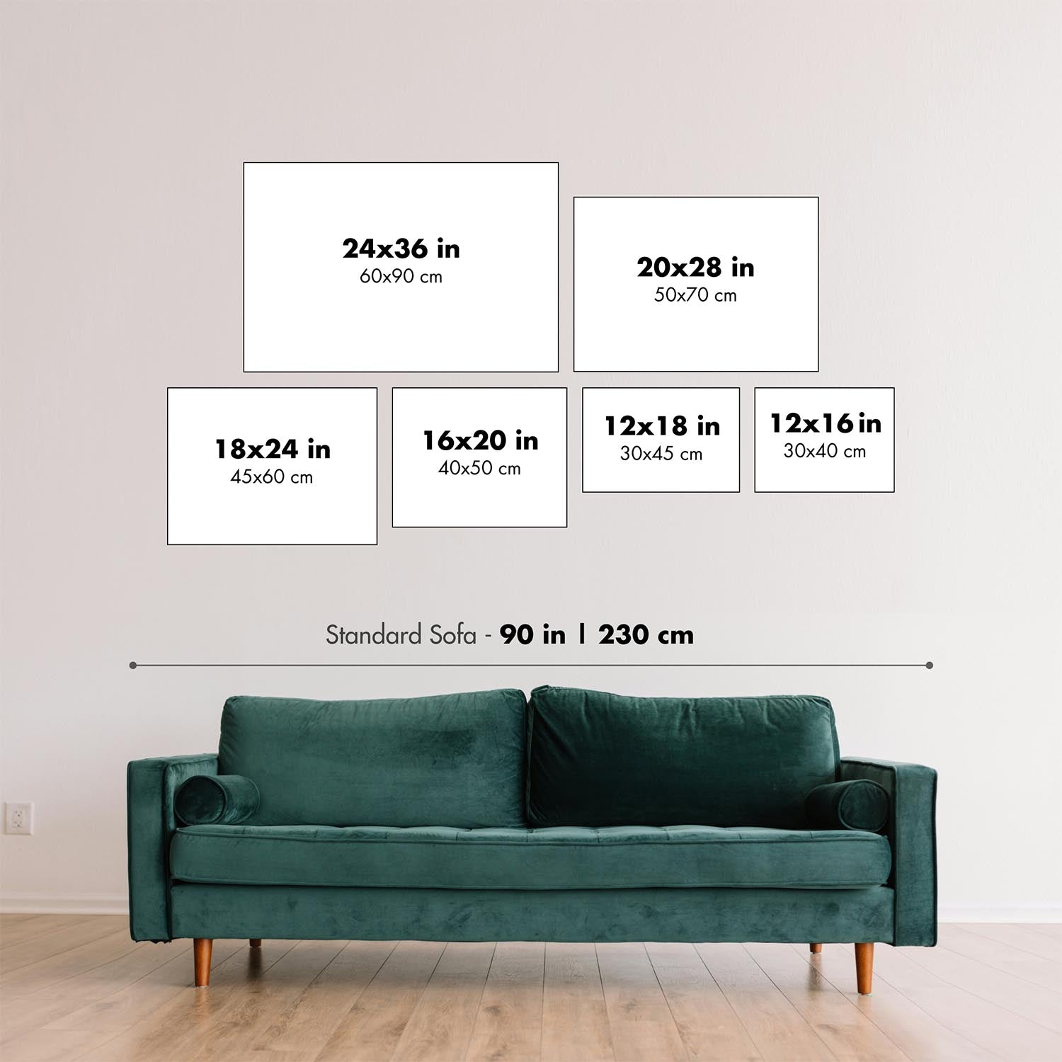
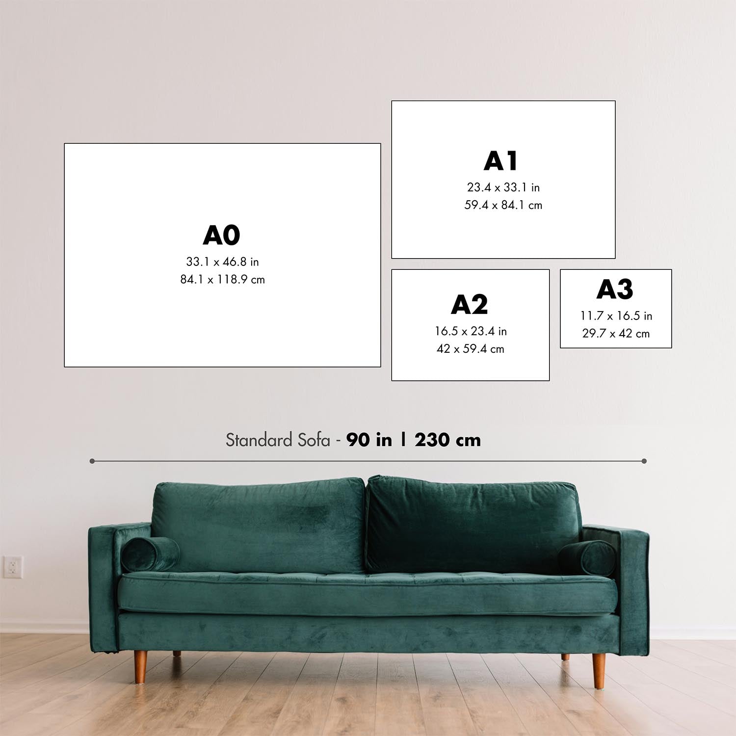
1. Select your size
2. Frame & personalize your map
Make your map unique with framing, hand-drawn customisation, vintage ageing, pop art text, unique 3D styling and moreGift message & custom finish

If you want to add a gift message, or a finish (jigsaw, aluminium board, etc.) that is not available here, please request it in the "order note" when you check out.
Every order is custom made, so if you need the size adjusted slightly, or printed on an unusual material, just let us know. We've done thousands of custom orders over the years, so there's (almost) nothing we can't manage.
You can also contact us before you order, if you prefer!

- Handmade locally. No import duty or tax
- FREE Delivery. Arrives in 2-3 days
- Love it or your money back
- Questions? WhatsApp me any time
Own a piece of history
5,000+ 5 star reviews


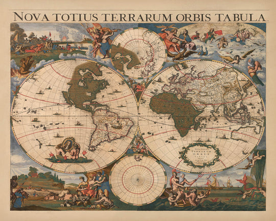
Realizzata dall'illustre Cornelis I Danckerts nel 1696, la "Nova Totius Terrarum Orbis Tabula" è un affascinante testamento all'era delle esplorazioni e dell'arte cartografica. Questa mappa eccezionalmente rara, un capolavoro del suo tempo, riflette il ricco lascito della famiglia Danckerts, rinomata per i suoi contributi alla cartografia ad Amsterdam. Con i suoi colori originali vivaci, questa mappa non solo rappresenta il mondo conosciuto, ma cattura anche l'immaginazione con la sua geografia speculativa, offrendo uno sguardo nello spirito avventuroso del XVII secolo.
La mappa è adornata da una straordinaria proiezione a doppia emisphere, completata da due insets polari che rivelano i misteri delle estremità della Terra. È un ritratto vivido del mondo così come veniva compreso, e spesso frainteso, in un'epoca in cui gli esploratori erano spinti dall'attrazione di territori inesplorati. La raffigurazione della California come un'isola e il mitico Stretto di Anian sono promemoria intriganti delle misconcezioni geografiche dell'epoca e della incessante ricerca di nuovi passaggi e terre.
Il lavoro di Danckerts è ulteriormente distinto dai suoi bordi decorativi, che sono tanto informativi quanto belli. Ogni angolo della mappa rappresenta uno degli elementi classici: fuoco, aria, acqua e terra. Queste illustrazioni allegoriche aggiungono un livello di profondità e arte, trasformando la mappa in una narrazione visiva che si estende oltre la mera geografia. L'angolo in alto a sinistra, con la sua raffigurazione del fuoco, evoca il potere esplosivo della scoperta, mentre la scena pastorale che rappresenta la terra radica la mappa nella realtà del mondo conosciuto.
Questa mappa funge anche da documento storico, catturando il contesto politico e culturale del suo tempo. Il ritratto dedicato al re Guglielmo III d'Inghilterra, presentato in modo prominente, evidenzia il legame della mappa con le figure significative dell'epoca. Riflette le dinamiche geopolitiche e l'influenza delle potenze europee nella narrazione dell'esplorazione globale. La presenza di terre mitiche come Yedso e Compagnies Land sottolinea il mix di fatto e finzione che ha caratterizzato la cartografia dell'età moderna.
In sostanza, la "Nova Totius Terrarum Orbis Tabula" è più di una semplice mappa; è una finestra sul passato, che offre intuizioni sulle aspirazioni e le immaginazioni di coloro che hanno tracciato l'ignoto. La sua combinazione di cartografia accurata ed elementi speculativi invita gli spettatori a esplorare non solo il mondo fisico, ma anche le possibilità illimitate che si trovano oltre l'orizzonte. Questa mappa è un vero pezzo da collezione, una celebrazione dello spirito avventuroso che continua a ispirare esploratori e storici allo stesso modo.
Paesi e regioni su questa mappa
- Continenti:
- America del Nord
- America del Sud
- Europa
- Africa
- Asia
- Australia
- Antartide (Tierra del Fuego)
- Regioni:
- Groenlandia
- California (come un'isola)
- Nuova Zelanda
- Cina
- Hokkaido (come Yedso)
- Nuova Guinea
Caratteristiche e punti di riferimento notevoli
- Mappe in insetto:
- Due insets polari (Polo Nord e Polo Sud).
- Corpi idrici:
- La raffigurazione della California come un'isola.
- Un grande lago che rappresenta i Grandi Laghi.
- Illustrazioni decorative:
- Quattro angoli che rappresentano gli elementi: fuoco, aria, acqua, terra.
- Terre mitiche:
- Yedso, Staten e Compagnies Land.
- Stretto di Anian che suggerisce un Passaggio a Nord-Ovest.
- Caratteristiche Aggiuntive:
- Grande Muraglia Cinese contrassegnata.
- Nuova Zelanda mostrata come una costa frammentata.
- Australia collegata alla Nuova Guinea.
Contesto storico e di design
- Data di Creazione: 1696
- Cartografo/Editore: Cornelis I Danckerts
- Contesto Storico:
- Eccezionalmente raro, solo il secondo esempio conosciuto.
- Probabilmente pubblicato inizialmente da Frederick de Wit a metà degli anni '60 del 1600.
- Ritratto dedicato al re Guglielmo III d'Inghilterra.
- Temi e Argomenti:
- Mappa del mondo a doppio emisfero con inserimenti polari.
- Esplorazione geografica e terre mitiche.
- Bordi decorativi che rappresentano i quattro elementi.
- Design e Stile:
- Esempio di colori antichi sorprendente.
- Bordo decorativo con elementi e scene classiche.
- Uso di geografia mitica e speculativa.
Si prega di controllare attentamente le immagini per assicurarsi che una certa città o luogo sia mostrato su questa mappa. Puoi anche contattarci e chiedere di controllare la mappa per te.
Questa è una mappa molto grande che deve essere ordinata in dimensioni grandi, in modo da poter facilmente distinguere tutti i dettagli.
Questa mappa appare straordinaria in dimensioni fino a 70 pollici (180 cm). Se stai cercando una mappa più grande, per favore contattaci.
Il modello nelle immagini dell'inserzione tiene la versione di questa mappa 16x20 pollici (40x50 cm).
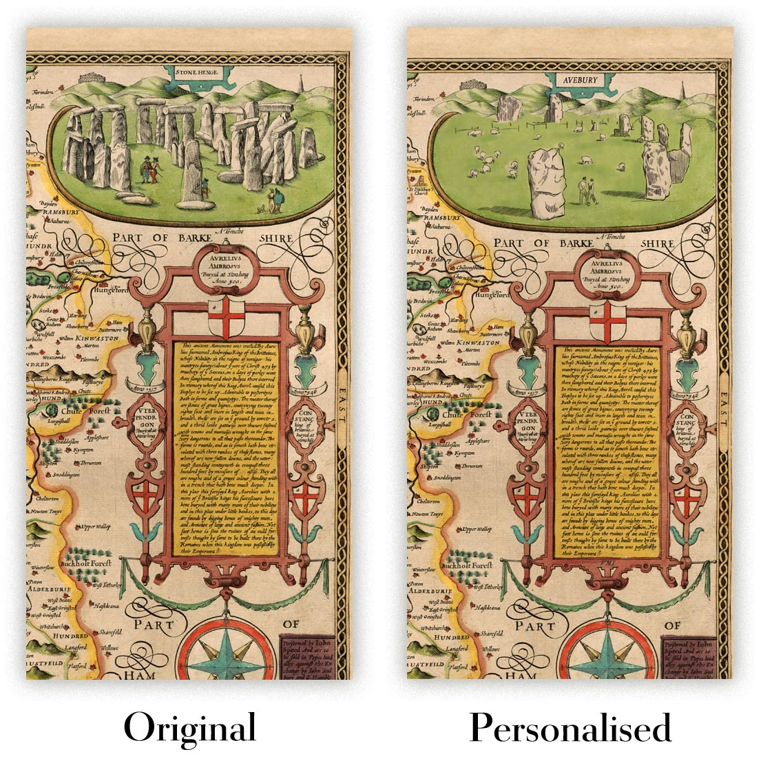
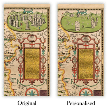
La quinta immagine dell'inserzione mostra un esempio del mio servizio di personalizzazione della mappa.
Se stai cercando qualcosa di leggermente diverso, dai un'occhiata alla mia collezione delle migliori mappe antiche per vedere se qualcos'altro cattura la tua attenzione.
Per favore contattami per controllare se una certa posizione, punto di riferimento o caratteristica è mostrata su questa mappa.
Questo sarebbe un meraviglioso regalo per un compleanno, Natale, Festa del Papà, festa di congedo dal lavoro, anniversario o inaugurazione della casa per qualcuno delle aree coperte da questa mappa.
Questa mappa è disponibile come stampa giclée su carta opaca archiviabile senza acidi, oppure puoi acquistarla incorniciata. La cornice è una semplice cornice nera che si adatta alla maggior parte degli stili. Per favore contattaci se desideri un colore o un materiale di cornice diverso. Le mie cornici sono dotate di un vetro acrilico super chiaro di grado museale (perspex/acrylite), che è significativamente meno riflettente del vetro, più sicuro e arriverà sempre in perfette condizioni.
This map is also available as a float framed canvas, sometimes known as a shadow gap framed canvas or canvas floater. The map is printed on artist's cotton canvas and then stretched over a handmade box frame. We then "float" the canvas inside a wooden frame, which is available in a range of colours (black, dark brown, oak, antique gold and white). This is a wonderful way to present a map without glazing in front. See some examples of float framed canvas maps and explore the differences between my different finishes.
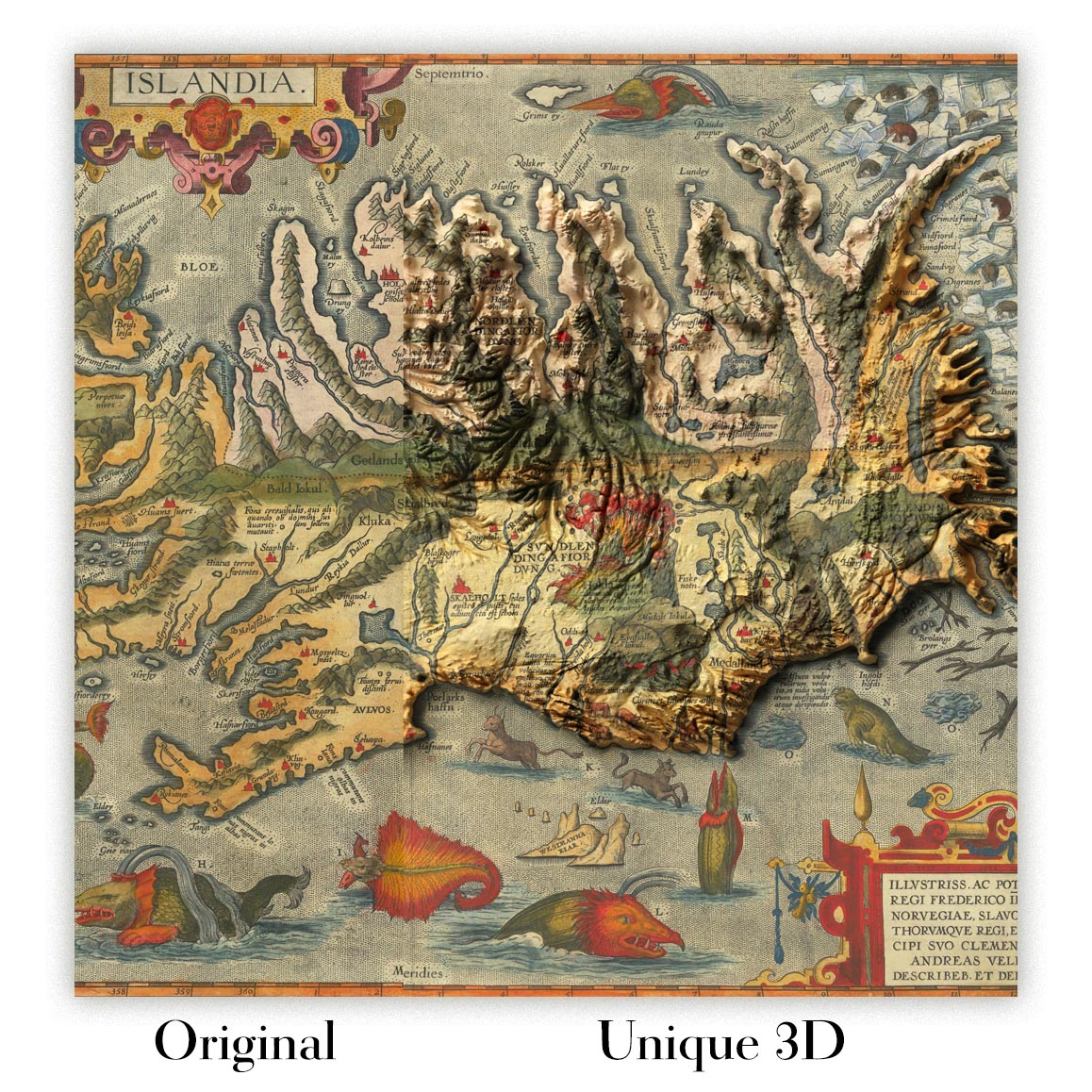
For something truly unique, this map is also available in "Unique 3D", our trademarked process that dramatically transforms the map so that it has a wonderful sense of depth. We combine the original map with detailed topography and elevation data, so that mountains and the terrain really "pop". For more info and examples of 3D maps, check my Unique 3D page.
For most orders, delivery time is about 3 working days. Personalised and customised products take longer, as I have to do the personalisation and send it to you for approval, which usually takes 1 or 2 days.
Please note that very large framed orders usually take longer to make and deliver.
If you need your order to arrive by a certain date, please contact me before you order so that we can find the best way of making sure you get your order in time.
I print and frame maps and artwork in 23 countries around the world. This means your order will be made locally, which cuts down on delivery time and ensures that it won't be damaged during delivery. You'll never pay customs or import duty, and we'll put less CO2 into the air.
All of my maps and art prints are well packaged and sent in a rugged tube if unframed, or surrounded by foam if framed.
I try to send out all orders within 1 or 2 days of receiving your order, though some products (like face masks, mugs and tote bags) can take longer to make.
If you select Express Delivery at checkout your order we will prioritise your order and send it out by 1-day courier (Fedex, DHL, UPS, Parcelforce).
Next Day delivery is also available in some countries (US, UK, Singapore, UAE) but please try to order early in the day so that we can get it sent out on time.
My standard frame is a gallery style black ash hardwood frame. It is simple and quite modern looking. My standard frame is around 20mm (0.8in) wide.
I use super-clear acrylic (perspex/acrylite) for the frame glass. It's lighter and safer than glass - and it looks better, as the reflectivity is lower.
Six standard frame colours are available for free (black, dark brown, dark grey, oak, white and antique gold). Custom framing and mounting/matting is available if you're looking for something else.
Most maps, art and illustrations are also available as a framed canvas. We use matte (not shiny) cotton canvas, stretch it over a sustainably sourced box wood frame, and then 'float' the piece within a wood frame. The end result is quite beautiful, and there's no glazing to get in the way.
All frames are provided "ready to hang", with either a string or brackets on the back. Very large frames will have heavy duty hanging plates and/or a mounting baton. If you have any questions, please get in touch.
See some examples of my framed maps and framed canvas maps.
Alternatively, I can also supply old maps and artwork on canvas, foam board, cotton rag and other materials.
If you want to frame your map or artwork yourself, please read my size guide first.
Alcune delle mie vecchie mappe sono ora disponibili come tele incorniciate. Per favore contattami se desideri ordinare una dimensione che non è disponibile nel mio negozio.
Le vecchie mappe su tela sono un'alternativa interessante alle mappe incorniciate in modo convenzionale. A seconda del tuo gusto personale e dell'arredamento della stanza, le mappe su tela possono "risaltare" un po' di più rispetto a una mappa incorniciata.
My maps are extremely high quality reproductions of original maps.
I source original, rare maps from libraries, auction houses and private collections around the world, restore them at my London workshop, and then use specialist giclée inks and printers to create beautiful maps that look even better than the original.
My maps are printed on acid-free archival matte (not glossy) paper that feels very high quality and almost like card. In technical terms the paper weight/thickness is 10mil/200gsm. It's perfect for framing.
I print with Epson ultrachrome giclée UV fade resistant pigment inks - some of the best inks you can find.
I can also make maps on canvas, cotton rag and other exotic materials.
Learn more about The Unique Maps Co.
Map personalisation
If you're looking for the perfect anniversary or housewarming gift, I can personalise your map to make it truly unique. For example, I can add a short message, or highlight an important location, or add your family's coat of arms.
The options are almost infinite. Please see my map personalisation page for some wonderful examples of what's possible.
To order a personalised map, select "personalise your map" before adding it to your basket.
Get in touch if you're looking for more complex customisations and personalisations.
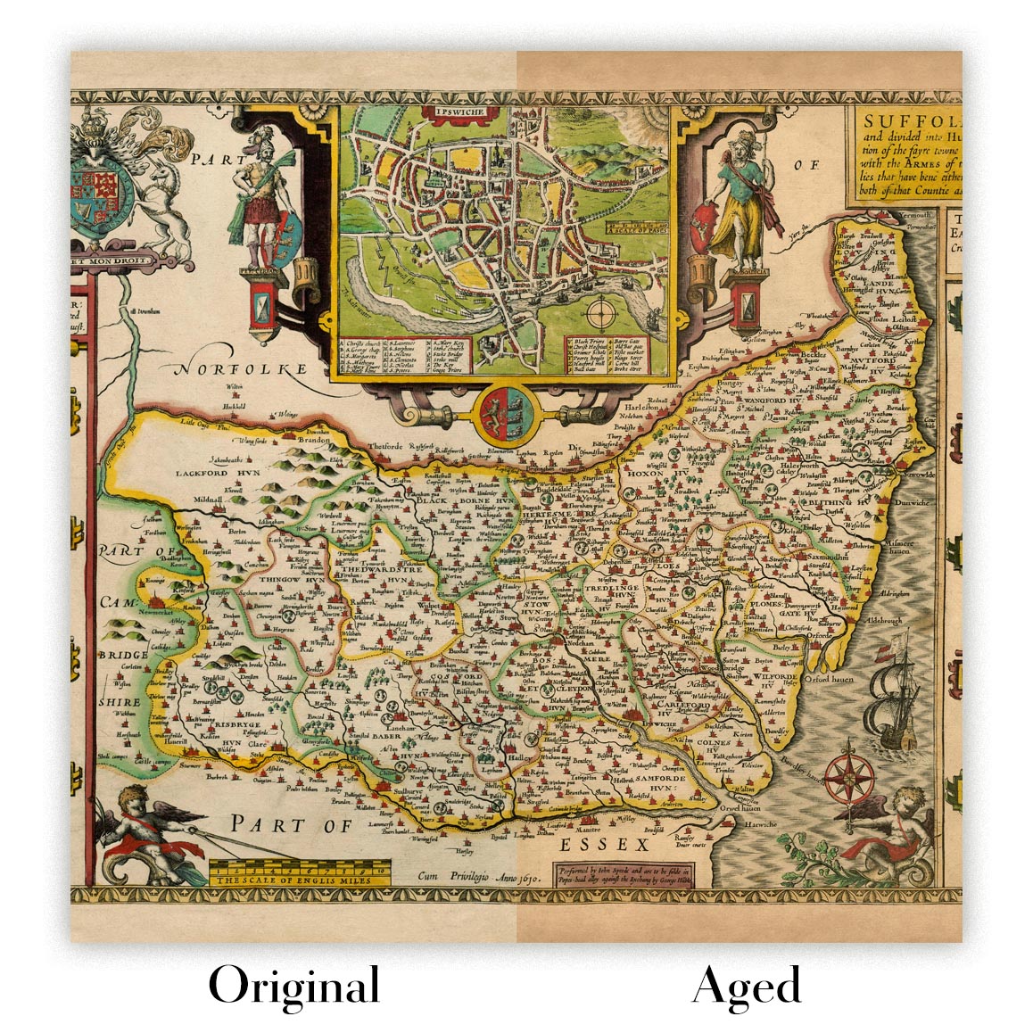
Map ageing
I have been asked hundreds of times over the years by customers if they could buy a map that looks even older.
Well, now you can, by selecting Aged before you add a map to your basket.
All the product photos you see on this page show the map in its Original form. This is what the map looks like today.
If you select Aged, I will age your map by hand, using a special and unique process developed through years of studying old maps, talking to researchers to understand the chemistry of aging paper, and of course... lots of practice!
If you're unsure, stick to the Original colour of the map. If you want something a bit darker and older looking, go for Aged.
Se non sei soddisfatto del tuo ordine per qualsiasi motivo, contattami per un rimborso senza problemi. Si prega di consultare la nostra politica di reso e rimborso per ulteriori informazioni.
Sono molto sicuro che ti piacerà la tua mappa restaurata o la stampa d'arte. Lo faccio dal 1984. Sono un venditore Etsy a 5 stelle. Ho venduto decine di migliaia di mappe e stampe d'arte e ho oltre 5.000 recensioni reali a 5 stelle.
Utilizzo un processo unico per restaurare mappe e opere d'arte che richiede molto tempo e lavoro. Trovare le mappe e le illustrazioni originali può richiedere mesi. Utilizzo tecnologia all'avanguardia e incredibilmente costosa per scannerizzare e restaurarle. Di conseguenza, garantisco che le mie mappe e stampe d'arte siano superiori alle altre - ecco perché posso offrire un rimborso senza problemi.
Quasi tutte le mie mappe e stampe d'arte sembrano fantastiche a grandi dimensioni (200 cm, 6,5 piedi+) e posso anche incorniciarle e consegnarle a te, tramite un corriere speciale per oggetti di grandi dimensioni. Contattami per discutere delle tue esigenze specifiche.
Or try searching for something!


