

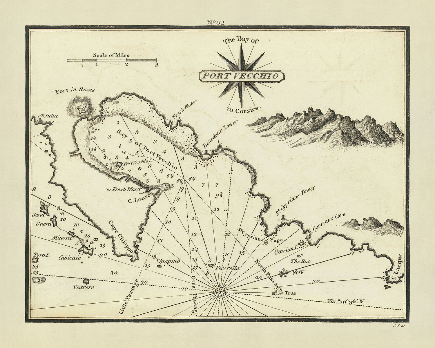


Vecchia carta nautica di Porto-Vecchio di Heather, 1802: Battaglia delle Îles Sanguinaires, relitto della La Sémillante, Faro di Lavezzi
Compra 2, Ricevi 1 Gratuito
Se aggiungi 2 articoli al tuo carrello, puoi aggiungere un terzo prodotto gratuitamente.
Questo vale per tutte le mappe e opere d'arte, comprese le opere personalizzate e su misura. Puoi ordinare 3 dello stesso articolo, o 3 articoli diversi.
Questo equivale a uno sconto del 33%, che sarà il maggiore sconto disponibile nel mio negozio quest'anno.
Ti prego di approfittare dell'offerta e di coprire le tue pareti con bellissime mappe e opere d'arte!
Contattami se hai domande.

-
![]() Handmade in the USA
Handmade in the USA
-
FREE worldwide delivery in 2-3 days ⓘ
Free delivery in 2-3 days
Your map should be delivered in 2-3 working days with free delivery, worldwide.
Deliveries over the Christmas and New Year period may be slightly delayed, as couriers and postal services catch up with a huge backlog of packages.
We make maps by hand locally in 23 countries. If you're buying a gift for someone in another country, we will make the map locally to them.
You will never pay import tax or customs duty.
Express delivery is available at checkout which can reduce the delivery time to 1-2 days.
Please note that personalised maps, and larger framed maps, can take longer to produce and deliver.
If you need your order to arrive by a certain date, contact me and we can discuss your options.
-
FREE gift preview
ⓘ
Digital gift preview
After you complete your order, you can send a beautiful digital preview to the gift recipient. Just provide their email address and we'll do the rest. (Their email address will not be stored or used for any other purpose.)
This is perfect if you're concerned that your order might not arrive in time.
You can also buy a real non-expiring gift card, and email it directly to the recipient, so they can buy their own map or artwork.
-
90 day money back guarantee
ⓘ
90 giorni per restituire e ricevere un rimborso
I prodotti possono essere restituiti entro 90 giorni per un rimborso completo, o cambio con un altro prodotto.
Per articoli personalizzati e su misura, potremmo offrirti un credito in negozio o una carta regalo non scadente, poiché non possiamo rivendere ordini personalizzati.
Se hai domande, contattaci. Per ulteriori informazioni, consulta la nostra politica di restituzione e cambio.

My maps are rare, museum-grade, restored old maps sourced from libraries, auction houses and private collections across the globe.
Framing & free personalisation available
1. Select your size
Click here to order a custom size.
2. Frame & personalize your map
Make your map unique with framing, hand-drawn customisation, vintage ageing, pop art text, unique 3D styling and more.


Gift message & custom finish

If you want to add a gift message, or a finish (jigsaw, aluminium board, etc.) that is not available here, please request it in the "order note" when you check out.
Every order is custom made, so if you need the size adjusted slightly, or printed on an unusual material, just let us know. We've done thousands of custom orders over the years, so there's (almost) nothing we can't manage.
You can also contact us before you order, if you prefer!

- Handmade locally. No import duty or tax
- FREE worldwide delivery
- Love it or your money back (90 days)
- Questions? WhatsApp me any time
Own a piece of history
5,000+ 5 star reviews


Fai un passo nel passato con l'esclusiva carta nautica "La Baia di Port Vecchio in Corsica," un raro gioiello dell'inizio del XIX secolo. Realizzata dall'illustre William Heather nel 1802, questa carta non è solo un pezzo di navigazione ma anche un'opera d'arte, distinta dalla sua orientazione con ovest in alto. Come parte dell'ambizioso progetto di Heather, "Il Nuovo Pilota del Mediterraneo," questa carta segna un significativo contributo inglese alla cartografia marittima, che era precedentemente dominata dagli sforzi francesi e italiani. Le incisioni dettagliate di John Stephenson evidenziano la meticolosa maestria artigianale che distingue questa carta, rendendola un possesso prezioso per collezionisti e appassionati di storia marittima.
La carta dettaglia meticolosamente la costa sud-orientale della Corsica, concentrandosi sulla strategica Baia di Porto-Vecchio. Include una serie di rilevamenti, caratteristiche topografiche e ancoraggi, cruciali per la navigazione e la comprensione del paesaggio marittimo dell'epoca. L'inclusione di un piano dettagliato del villaggio di Porto-Vecchio e delle sue aree circostanti offre uno sguardo sulla vita costiera in Corsica durante i primi anni del 1800. Questa carta non solo serviva come guida pratica per i marinai ma anche come registro dettagliato delle caratteristiche geografiche e artificiali di questa storica regione.
Oltre alla sua utilità navigazionale, la carta è un deposito di racconti storici e leggende marittime. Segna siti storici significativi come la posizione della Battaglia delle Îles Sanguinaires e il tragico naufragio della nave da guerra francese La Sémillante. La raffigurazione del Faro di Lavezzi, costruito anni dopo la pubblicazione della carta, e dell'antica Cittadella di Porto-Vecchio, costruita nel XVI secolo, aggiunge strati di profondità storica, invitando i visitatori a esplorare il ricco passato della Corsica e il suo patrimonio marittimo.
Questa carta non è solo rara ma occupa anche un posto speciale nella storia della cartografia. Essendo il primo esempio di questa carta mai visto sul mercato, la sua unicità è senza pari. Le carte del "Nuovo Pilota del Mediterraneo" di Heather sono conosciute per la loro rarità e la fine qualità delle incisioni, rendendole estremamente ricercate nel mercato dei collezionisti. Questa particolare carta, con le sue incisioni dettagliate e annotazioni storiche, offre una finestra unica sul passato del Mediterraneo, rendendola un must-have per chi è appassionato di storia e cartografia.
In conclusione, "La Baia di Port Vecchio in Corsica" è più di una semplice mappa; è un documento storico che cattura l'essenza della storia marittima corsa. La sua rappresentazione dettagliata delle caratteristiche nautiche e topografiche, combinata con le sue ricche annotazioni storiche, la rende una risorsa inestimabile per chiunque sia interessato alla storia navale del Mediterraneo. La maestria di William Heather, arricchita dalle fine incisioni di John Stephenson, assicura che questa carta rimanga una testimonianza dell'arte e della scienza della cartografia dell'inizio del XIX secolo.
Luoghi Notabili su Questa Mappa
- Porto-Vecchio
- Golfo di Porto-Vecchio
Caratteristiche e Monumenti Notabili
- Posizione della Battaglia delle Îles Sanguinaires (1543)
- Naufragio della nave da guerra francese La Sémillante (1855)
- Faro di Lavezzi (costruito nel 1899)
- Cittadella di Porto-Vecchio (costruita nel XVI secolo)
Contesto Storico e di Design
- Pubblicata da William Heather a Londra, 1802
- Parte de "Il Nuovo Pilota del Mediterraneo"
- Primo tentativo inglese di una raccolta di porti mediterranei
- Nota per le carte finemente incise di John Stephenson
- Le carte del pilota di Heather sono estremamente rare sul mercato
- Orientato con ovest in alto
Si prega di controllare attentamente le immagini per assicurarsi che una specifica città o luogo sia mostrato su questa mappa. Puoi anche contattarci e chiedere di controllare la mappa per te.
Questa mappa appare fantastica in ogni dimensione, ma consiglio sempre di optare per una dimensione più grande se hai spazio. In questo modo puoi facilmente distinguere tutti i dettagli.
Questa mappa appare incredibile in dimensioni fino a 50in (125cm). Se stai cercando una mappa più grande, ti prego di contattarci.
Il modello nelle immagini dell'inserzione sta tenendo la versione 16x20in (40x50cm) di questa mappa.
La quinta immagine dell'inserzione mostra un esempio del mio servizio di personalizzazione della mappa.
Se stai cercando qualcosa di leggermente diverso, dai un'occhiata alla mia collezione delle migliori mappe antiche per vedere se qualcosa attira la tua attenzione.
Per favore contattami per verificare se una certa posizione, punto di riferimento o caratteristica è mostrata su questa mappa.
Questa sarebbe una meravigliosa idea regalo per un compleanno, Natale, Festa del Papà, pensionamento, anniversario o inaugurazione della casa per qualcuno delle aree coperte da questa mappa.
Questa mappa è disponibile come stampa giclée su carta opaca archiviata senza acidi, oppure puoi acquistarla incorniciata. La cornice è una semplice cornice nera che si adatta alla maggior parte degli stili. Ti prego di contattarmi se desideri un colore o materiale diverso per la cornice. Le mie cornici sono dotate di un vetro acrilico (perspex/acrylite) super chiaro di qualità museale, che è significativamente meno riflettente del vetro, più sicuro e arriverà sempre in perfette condizioni.
This map is also available as a float framed canvas, sometimes known as a shadow gap framed canvas or canvas floater. The map is printed on artist's cotton canvas and then stretched over a handmade box frame. We then "float" the canvas inside a wooden frame, which is available in a range of colours (black, dark brown, oak, antique gold and white). This is a wonderful way to present a map without glazing in front. See some examples of float framed canvas maps and explore the differences between my different finishes.
For something truly unique, this map is also available in "Unique 3D", our trademarked process that dramatically transforms the map so that it has a wonderful sense of depth. We combine the original map with detailed topography and elevation data, so that mountains and the terrain really "pop". For more info and examples of 3D maps, check my Unique 3D page.
For most orders, delivery time is about 3 working days. Personalised and customised products take longer, as I have to do the personalisation and send it to you for approval, which usually takes 1 or 2 days.
Please note that very large framed orders usually take longer to make and deliver.
If you need your order to arrive by a certain date, please contact me before you order so that we can find the best way of making sure you get your order in time.
I print and frame maps and artwork in 23 countries around the world. This means your order will be made locally, which cuts down on delivery time and ensures that it won't be damaged during delivery. You'll never pay customs or import duty, and we'll put less CO2 into the air.
All of my maps and art prints are well packaged and sent in a rugged tube if unframed, or surrounded by foam if framed.
I try to send out all orders within 1 or 2 days of receiving your order, though some products (like face masks, mugs and tote bags) can take longer to make.
If you select Express Delivery at checkout your order we will prioritise your order and send it out by 1-day courier (Fedex, DHL, UPS, Parcelforce).
Next Day delivery is also available in some countries (US, UK, Singapore, UAE) but please try to order early in the day so that we can get it sent out on time.
My standard frame is a gallery style black ash hardwood frame. It is simple and quite modern looking. My standard frame is around 20mm (0.8in) wide.
I use super-clear acrylic (perspex/acrylite) for the frame glass. It's lighter and safer than glass - and it looks better, as the reflectivity is lower.
Six standard frame colours are available for free (black, dark brown, dark grey, oak, white and antique gold). Custom framing and mounting/matting is available if you're looking for something else.
Most maps, art and illustrations are also available as a framed canvas. We use matte (not shiny) cotton canvas, stretch it over a sustainably sourced box wood frame, and then 'float' the piece within a wood frame. The end result is quite beautiful, and there's no glazing to get in the way.
All frames are provided "ready to hang", with either a string or brackets on the back. Very large frames will have heavy duty hanging plates and/or a mounting baton. If you have any questions, please get in touch.
See some examples of my framed maps and framed canvas maps.
Alternatively, I can also supply old maps and artwork on canvas, foam board, cotton rag and other materials.
If you want to frame your map or artwork yourself, please read my size guide first.
Alcune delle mie vecchie mappe sono ora disponibili come tele incorniciate. Per favore contattami se desideri ordinare una dimensione che non è disponibile nel mio negozio.
Le vecchie mappe su tela sono un'alternativa interessante alle mappe incorniciate in modo convenzionale. A seconda del tuo gusto personale e dell'arredamento della stanza, le mappe su tela possono "risaltare" un po' di più rispetto a una mappa incorniciata.
My maps are extremely high quality reproductions of original maps.
I source original, rare maps from libraries, auction houses and private collections around the world, restore them at my London workshop, and then use specialist giclée inks and printers to create beautiful maps that look even better than the original.
My maps are printed on acid-free archival matte (not glossy) paper that feels very high quality and almost like card. In technical terms the paper weight/thickness is 10mil/200gsm. It's perfect for framing.
I print with Epson ultrachrome giclée UV fade resistant pigment inks - some of the best inks you can find.
I can also make maps on canvas, cotton rag and other exotic materials.
Learn more about The Unique Maps Co.
Map personalisation
If you're looking for the perfect anniversary or housewarming gift, I can personalise your map to make it truly unique. For example, I can add a short message, or highlight an important location, or add your family's coat of arms.
The options are almost infinite. Please see my map personalisation page for some wonderful examples of what's possible.
To order a personalised map, select "personalise your map" before adding it to your basket.
Get in touch if you're looking for more complex customisations and personalisations.
Map ageing
I have been asked hundreds of times over the years by customers if they could buy a map that looks even older.
Well, now you can, by selecting Aged before you add a map to your basket.
All the product photos you see on this page show the map in its Original form. This is what the map looks like today.
If you select Aged, I will age your map by hand, using a special and unique process developed through years of studying old maps, talking to researchers to understand the chemistry of aging paper, and of course... lots of practice!
If you're unsure, stick to the Original colour of the map. If you want something a bit darker and older looking, go for Aged.
Se non sei soddisfatto del tuo ordine per qualsiasi motivo, contattami per un rimborso senza problemi. Si prega di consultare la nostra politica di reso e rimborso per ulteriori informazioni.
Sono molto sicuro che ti piacerà la tua mappa restaurata o la stampa d'arte. Lo faccio dal 1984. Sono un venditore Etsy a 5 stelle. Ho venduto decine di migliaia di mappe e stampe d'arte e ho oltre 5.000 recensioni reali a 5 stelle.
Utilizzo un processo unico per restaurare mappe e opere d'arte che richiede molto tempo e lavoro. Trovare le mappe e le illustrazioni originali può richiedere mesi. Utilizzo tecnologia all'avanguardia e incredibilmente costosa per scannerizzare e restaurarle. Di conseguenza, garantisco che le mie mappe e stampe d'arte siano superiori alle altre - ecco perché posso offrire un rimborso senza problemi.
Quasi tutte le mie mappe e stampe d'arte sembrano fantastiche a grandi dimensioni (200 cm, 6,5 piedi+) e posso anche incorniciarle e consegnarle a te, tramite un corriere speciale per oggetti di grandi dimensioni. Contattami per discutere delle tue esigenze specifiche.
Or try searching for something!


