


Vecchia mappa del Massachusetts di J.H. Colton, 1855: Boston, Worcester, Springfield, Lowell e New Bedford
Compra 2, Ricevi 1 Gratuito
Se aggiungi 2 articoli al tuo carrello, puoi aggiungere un terzo prodotto gratuitamente.
Questo vale per tutte le mappe e opere d'arte, comprese le opere personalizzate e su misura. Puoi ordinare 3 dello stesso articolo, o 3 articoli diversi.
Questo equivale a uno sconto del 33%, che sarà il maggiore sconto disponibile nel mio negozio quest'anno.
Ti prego di approfittare dell'offerta e di coprire le tue pareti con bellissime mappe e opere d'arte!
Contattami se hai domande.
-
![]() Handmade in the USA
Handmade in the USA

-
FREE worldwide delivery in 2-3 days ⓘ
Free delivery in 2-3 days
Your map should be delivered in 2-3 working days with free delivery, worldwide.
We make maps by hand locally in 23 countries. If you're buying a gift for someone in another country, we will make the map locally to them.
You will never pay import tax or customs duty.
Express delivery is available at checkout which can reduce the delivery time to 1-2 days.
Please note that personalised maps, and larger framed maps, can take longer to produce and deliver.
If you need your order to arrive by a certain date, contact me and we can discuss your options.
-
Complimentary gifting & design advice
ⓘ
Complimentary gifting & design advice
Available almost 24/7 on WhatsApp and email — we usually reply within minutes. We can help you:
- Choose a perfectly personalised gift
- Send a digital gift preview to the recipient
- Pick the ideal size for your wall
- Select the right finish and frame
Quick, friendly advice so you can order with confidence.
For last minute gifts, consider buying a digital gift card. We have over 5,000 maps and art prints to choose from.
-
90-day returns & 5-year guarantee
ⓘ
90 giorni per restituire e ricevere un rimborso
I prodotti possono essere restituiti entro 90 giorni per un rimborso completo, o cambio con un altro prodotto.
Per articoli personalizzati e su misura, potremmo offrirti un credito in negozio o una carta regalo non scadente, poiché non possiamo rivendere ordini personalizzati.
Se hai domande, contattaci. Per ulteriori informazioni, consulta la nostra politica di restituzione e cambio.

This is a museum-grade archival print from the original 1855 map — restored in our workshop and made to order on 220gsm archival matte paper or 400gsm artist's cotton canvas with pigment inks.
Professional framing & free personalisation available
1. Choose a size
2. Frame & personalize your map
Make your map unique with framing, hand-drawn customisation, vintage ageing, pop art text, unique 3D styling and more.


Gift message & custom finish

If you want to add a gift message, or a finish (jigsaw, aluminium board, etc.) that is not available here, please request it in the "order note" when you check out.
Every order is custom made, so if you need the size adjusted slightly, or printed on an unusual material, just let us know. We've done thousands of custom orders over the years, so there's (almost) nothing we can't manage.
You can also contact us before you order, if you prefer!

- Handmade locally. No import duty or tax
- FREE worldwide delivery
- 90-day returns & 5-year product guarantee
- Questions? WhatsApp me any time
Own a piece of history
7,000+ 5 star reviews


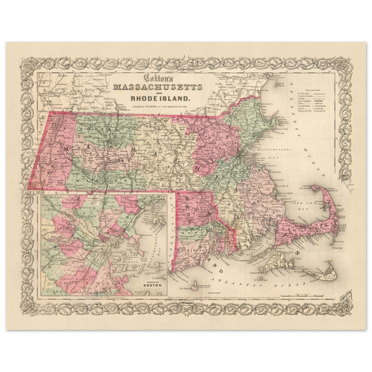
Questa mappa è un pezzo straordinario della storia americana, risalente alla metà del XIX secolo, un periodo di significativa crescita e cambiamento negli Stati Uniti. Realizzata da J.H. Colton, ampiamente riconosciuto come uno dei migliori cartografi americani della sua epoca, questa mappa del 1855 del Massachusetts offre uno sguardo affascinante sui primi giorni della nazione. In questo periodo, molti insediamenti che conosciamo oggi non erano ancora stati fondati, e i nomi e i confini di quelli già esistenti erano probabilmente diversi da quelli con cui siamo familiari oggi.
La mappa mostra l'arte e la meticolosità che Colton era famoso per. Fornisce un'istantanea accattivante del Massachusetts com'era nel 1855, completa dei più notevoli insediamenti dell'epoca. Questi includono Boston, Worcester, Springfield, Lowell e New Bedford, ognuno dei quali ha svolto un ruolo significativo nella storia e nello sviluppo dello stato.
È importante ricordare che questa mappa è stata creata solo pochi decenni dopo che gli Stati Uniti dichiararono la loro indipendenza. È una testimonianza della rapida crescita e espansione che ha caratterizzato questo periodo nella storia americana. I cambiamenti nei nomi e nei confini negli ultimi 150 anni riflettono la natura dinamica ed evolutiva della nazione, rendendo questa mappa non solo un'opera d'arte, ma un pezzo tangibile della narrativa storica dell'America.
Massachusetts
- Boston (1630) - Nota storicamente come Shawmut e Trimountaine, Boston è notevole come la capitale e la città più grande dello stato. È stata un luogo chiave durante la Rivoluzione Americana, con eventi come il Massacro di Boston e il Boston Tea Party.
- Plymouth (1620) - Originariamente conosciuta come Plimouth e Plimoth, questa città è famosa per essere il luogo di sbarco del Mayflower e dei Pellegrini.
- Salem (1626) - Salem è conosciuta per i famosi Processi alle Streghe di Salem del 1692.
- Cambridge (1630) - Storicamente conosciuta come Newtowne, Cambridge ospita l'Università di Harvard, la più antica istituzione di istruzione superiore negli Stati Uniti.
- Quincy (1625) - Conosciuta in passato come Mount Wollaston, Braintree e Merrymount, Quincy è il luogo di nascita dei presidenti John Adams e John Quincy Adams.
- Worcester (1673) - Worcester ha svolto un ruolo chiave nella Guerra d'Indipendenza Americana.
- Springfield (1636) - Conosciuta come Agawam durante il 1600, Springfield è il luogo di nascita del basket.
- Lowell (1826) - Lowell è diventata un importante centro manifatturiero durante la Rivoluzione Industriale.
- New Bedford (1640) - Conosciuta come Bedford Village e Bedford, era il principale porto baleniero del mondo nel XIX secolo.
- Nantucket (1641) - Questa isola era un importante porto baleniero e commerciale.
- Martha's Vineyard (1642) - Questa isola era una base baleniera importante.
- Amherst (1759) - Nota per essere la casa di Emily Dickinson e dell'Università del Massachusetts Amherst.
- Pittsfield (1761) - Conosciuta come Pontoosuck fino al 1761, Pittsfield è famosa per essere stata il sito della prima fiera agricola negli Stati Uniti nel 1810.
- Salem (1626) - Conosciuta per i Processi alle Streghe di Salem del 1692.
- Barnstable (1636) - La comunità più grande del Cape Cod, nota per la sua storia marittima.
- Lexington (1642) - Conosciuta come Cambridge Farms prima del 1691, Lexington è famosa per essere il sito del primo colpo della Guerra di Indipendenza Americana.
- Concord (1635) - Famosa per la Battaglia di Lexington e Concord, la prima battaglia della Guerra di Indipendenza Americana.
- Northampton (1654) - Conosciuta come Norwottuck, o Nonotuck, il "mezzo del fiume" dai suoi abitanti Pocumtuc originali, è stata un sito importante per l'abolizionismo nel XIX secolo.
- Gloucester (1623) - Il porto marittimo più antico d'America, Gloucester è stato un importante centro di costruzione navale.
- Andover (1646) - Conosciuta per la Phillips Academy, una delle scuole secondarie più antiche e prestigiose degli Stati Uniti.
Tribù dei Nativi Americani
- Tribù Massachusett - La tribù da cui prende il nome lo stato, situata principalmente attorno all'area della Baia del Massachusetts.
- Tribù Wampanoag - Questa tribù era conosciuta per la loro interazione con i Pellegrini, che si stabilirono nel loro territorio.
- Tribù Nipmuc - Situata nel Massachusetts centrale, sono stati attori chiave nella Guerra di Re Filippo.
- Tribù Pocumtuc - Situata nel Massachusetts occidentale, erano conosciuti per la loro agricoltura e pesca.
Caratteristiche Naturali Notevoli
- I Berkshires - Questa catena montuosa è una popolare meta turistica per il suo bellissimo paesaggio e le attività all'aperto.
- Cape Cod - Conosciuta per le sue spiagge, i suoi villaggi pittoreschi e i frutti di mare.
- Fiume Charles - Famoso per il suo canottaggio, vela e opportunità ricreative.
- Monte Greylock - Il punto naturale più alto del Massachusetts con viste panoramiche.
- Serbatoio di Quabbin - Uno dei più grandi rifornimenti idrici pubblici artificiali negli Stati Uniti.
Eventi Storici (1810-1855)
- Guerra del 1812 (1812-1815) - Il Massachusetts ha svolto un ruolo significativo in questo conflitto, con diversi ingaggi navali e militari che si sono svolti al largo della sua costa.
- Fabbriche di Lowell (1826) - L'istituzione di questi mulini tessili ha segnato l'inizio della Rivoluzione Industriale in America.
- I Brahmini di Boston (1800) - Questo termine è stato coniato per rappresentare la classe elite di Boston durante quest'epoca, nota per la loro filantropia e influenza.
- La Famine della Patata Irlandese (1845-1852) - Questo evento ha portato a un significativo afflusso di immigrati irlandesi nel Massachusetts, in particolare a Boston.
Si prega di controllare attentamente le immagini per assicurarsi che una specifica città o luogo sia mostrato su questa mappa. Puoi anche contattarci e chiedere di controllare la mappa per te.
Questa mappa appare fantastica in tutte le dimensioni: 12x16in (30.5x41cm), 16x20in (40.5x51cm), 18x24in (45.5x61cm), 24x30in (61x76cm), 32x40in (81.5x102cm), 40x50in (102x127cm), 48x60in (122x153cm) e 56x70in (142x178cm), ma appare ancora meglio quando stampata in grande.
Posso creare stampe belle e grandi di questa mappa fino a 70in (178cm). Si prega di contattare se si cercano opzioni di incorniciatura più grandi, personalizzate o diverse.
Il modello nelle immagini dell'annuncio tiene la versione di questa mappa di 16x20in (40,5x51cm).
La quinta immagine dell'annuncio mostra un esempio del mio servizio di personalizzazione della mappa.
Se stai cercando qualcosa di leggermente diverso, dai un'occhiata alla mia principale collezione di mappe degli Stati Uniti e del Nord America.
Per favore contattami per verificare se una certa posizione, punto di riferimento o caratteristica è mostrata su questa mappa.
Questo sarebbe un meraviglioso regalo di compleanno, Natale, Festa del Papà, addio al lavoro, anniversario o inaugurazione della casa per qualcuno delle aree coperte da questa mappa.
Questa mappa è disponibile come stampa giclée su carta opaca archiviata senza acidi, oppure puoi acquistarla incorniciata. La cornice è una bella e semplice cornice nera che si adatta alla maggior parte degli stili. Per favore contattami se desideri un colore o materiale della cornice diverso. Le mie cornici sono vetriate con acrilico di grado museale super chiaro (perspex/acrylite), che è significativamente meno riflettente del vetro, più sicuro e arriverà sempre in perfette condizioni.
This map is also available as a float framed canvas, sometimes known as a shadow gap framed canvas or canvas floater. The map is printed on artist's cotton canvas and then stretched over a handmade box frame. We then "float" the canvas inside a wooden frame, which is available in a range of colours (black, dark brown, oak, antique gold and white). This is a wonderful way to present a map without glazing in front. See some examples of float framed canvas maps and explore the differences between my different finishes.
For something truly unique, this map is also available in "Unique 3D", our trademarked process that dramatically transforms the map so that it has a wonderful sense of depth. We combine the original map with detailed topography and elevation data, so that mountains and the terrain really "pop". For more info and examples of 3D maps, check my Unique 3D page.
For most orders, delivery time is about 3 working days. Personalised and customised products take longer, as I have to do the personalisation and send it to you for approval, which usually takes 1 or 2 days.
Please note that very large framed orders usually take longer to make and deliver.
If you need your order to arrive by a certain date, please contact me before you order so that we can find the best way of making sure you get your order in time.
I print and frame maps and artwork in 23 countries around the world. This means your order will be made locally, which cuts down on delivery time and ensures that it won't be damaged during delivery. You'll never pay customs or import duty, and we'll put less CO2 into the air.
All of my maps and art prints are well packaged and sent in a rugged tube if unframed, or surrounded by foam if framed.
I try to send out all orders within 1 or 2 days of receiving your order, though some products (like face masks, mugs and tote bags) can take longer to make.
If you select Express Delivery at checkout your order we will prioritise your order and send it out by 1-day courier (Fedex, DHL, UPS, Parcelforce).
Next Day delivery is also available in some countries (US, UK, Singapore, UAE) but please try to order early in the day so that we can get it sent out on time.
My standard frame is a gallery style black ash hardwood frame. It is simple and quite modern looking. My standard frame is around 20mm (0.8in) wide.
I use super-clear acrylic (perspex/acrylite) for the frame glass. It's lighter and safer than glass - and it looks better, as the reflectivity is lower.
Six standard frame colours are available for free (black, dark brown, dark grey, oak, white and antique gold). Custom framing and mounting/matting is available if you're looking for something else.
Most maps, art and illustrations are also available as a framed canvas. We use matte (not shiny) cotton canvas, stretch it over a sustainably sourced box wood frame, and then 'float' the piece within a wood frame. The end result is quite beautiful, and there's no glazing to get in the way.
All frames are provided "ready to hang", with either a string or brackets on the back. Very large frames will have heavy duty hanging plates and/or a mounting baton. If you have any questions, please get in touch.
See some examples of my framed maps and framed canvas maps.
Alternatively, I can also supply old maps and artwork on canvas, foam board, cotton rag and other materials.
If you want to frame your map or artwork yourself, please read my size guide first.
Alcune delle mie vecchie mappe sono ora disponibili come tele incorniciate. Per favore contattami se desideri ordinare una dimensione che non è disponibile nel mio negozio.
Le vecchie mappe su tela sono un'alternativa interessante alle mappe incorniciate in modo convenzionale. A seconda del tuo gusto personale e dell'arredamento della stanza, le mappe su tela possono "risaltare" un po' di più rispetto a una mappa incorniciata.
My maps are extremely high quality reproductions of original maps.
I source original, rare maps from libraries, auction houses and private collections around the world, restore them at my London workshop, and then use specialist giclée inks and printers to create beautiful maps that look even better than the original.
My maps are printed on acid-free archival matte (not glossy) paper that feels very high quality and almost like card. In technical terms the paper weight/thickness is 10mil/200gsm. It's perfect for framing.
I print with Epson ultrachrome giclée UV fade resistant pigment inks - some of the best inks you can find.
I can also make maps on canvas, cotton rag and other exotic materials.
Learn more about The Unique Maps Co.
Map personalisation
If you're looking for the perfect anniversary or housewarming gift, I can personalise your map to make it truly unique. For example, I can add a short message, or highlight an important location, or add your family's coat of arms.
The options are almost infinite. Please see my map personalisation page for some wonderful examples of what's possible.
To order a personalised map, select "personalise your map" before adding it to your basket.
Get in touch if you're looking for more complex customisations and personalisations.
Map ageing
I have been asked hundreds of times over the years by customers if they could buy a map that looks even older.
Well, now you can, by selecting Aged before you add a map to your basket.
All the product photos you see on this page show the map in its Original form. This is what the map looks like today.
If you select Aged, I will age your map by hand, using a special and unique process developed through years of studying old maps, talking to researchers to understand the chemistry of aging paper, and of course... lots of practice!
If you're unsure, stick to the Original colour of the map. If you want something a bit darker and older looking, go for Aged.
Se non sei soddisfatto del tuo ordine per qualsiasi motivo, contattami per un rimborso senza problemi. Si prega di consultare la nostra politica di reso e rimborso per ulteriori informazioni.
Sono molto sicuro che ti piacerà la tua mappa restaurata o la stampa d'arte. Lo faccio dal 1984. Sono un venditore Etsy a 5 stelle. Ho venduto decine di migliaia di mappe e stampe d'arte e ho oltre 5.000 recensioni reali a 5 stelle.
Utilizzo un processo unico per restaurare mappe e opere d'arte che richiede molto tempo e lavoro. Trovare le mappe e le illustrazioni originali può richiedere mesi. Utilizzo tecnologia all'avanguardia e incredibilmente costosa per scannerizzare e restaurarle. Di conseguenza, garantisco che le mie mappe e stampe d'arte siano superiori alle altre - ecco perché posso offrire un rimborso senza problemi.
Quasi tutte le mie mappe e stampe d'arte sembrano fantastiche a grandi dimensioni (200 cm, 6,5 piedi+) e posso anche incorniciarle e consegnarle a te, tramite un corriere speciale per oggetti di grandi dimensioni. Contattami per discutere delle tue esigenze specifiche.
Or try searching for something!


