


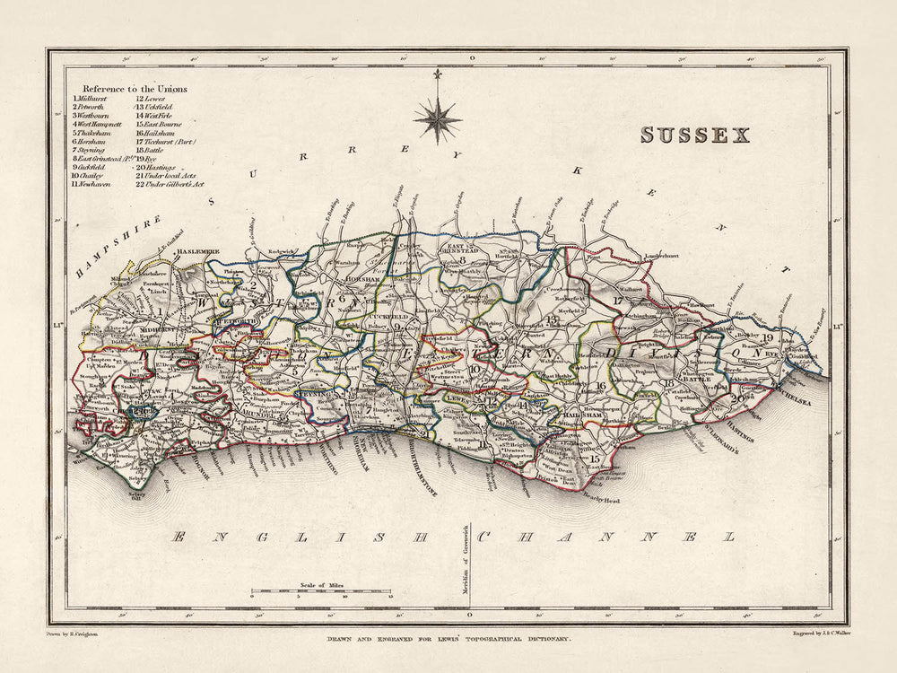


Antica mappa dell'Est e dell'Ovest Sussex di Samuel Lewis, 1844: Brighton, Crawley, Worthing, Eastbourne e Hastings
Compra 2, Ricevi 1 Gratuito
Se aggiungi 2 articoli al tuo carrello, puoi aggiungere un terzo prodotto gratuitamente.
Questo vale per tutte le mappe e opere d'arte, comprese le opere personalizzate e su misura. Puoi ordinare 3 dello stesso articolo, o 3 articoli diversi.
Questo equivale a uno sconto del 33%, che sarà il maggiore sconto disponibile nel mio negozio quest'anno.
Ti prego di approfittare dell'offerta e di coprire le tue pareti con bellissime mappe e opere d'arte!
Contattami se hai domande.
-
![]() Handmade in the USA
Handmade in the USA

-
FREE worldwide delivery in 2-3 days ⓘ
Free delivery in 2-3 days
Your map should be delivered in 2-3 working days with free delivery, worldwide.
We make maps by hand locally in 23 countries. If you're buying a gift for someone in another country, we will make the map locally to them.
You will never pay import tax or customs duty.
Express delivery is available at checkout which can reduce the delivery time to 1-2 days.
Please note that personalised maps, and larger framed maps, can take longer to produce and deliver.
If you need your order to arrive by a certain date, contact me and we can discuss your options.
-
Complimentary gifting & design advice
ⓘ
Complimentary gifting & design advice
Available almost 24/7 on WhatsApp and email — we usually reply within minutes. We can help you:
- Choose a perfectly personalised gift
- Send a digital gift preview to the recipient
- Pick the ideal size for your wall
- Select the right finish and frame
Quick, friendly advice so you can order with confidence.
For last minute gifts, consider buying a digital gift card. We have over 5,000 maps and art prints to choose from.
-
90-day returns & 5-year guarantee
ⓘ
90 giorni per restituire e ricevere un rimborso
I prodotti possono essere restituiti entro 90 giorni per un rimborso completo, o cambio con un altro prodotto.
Per articoli personalizzati e su misura, potremmo offrirti un credito in negozio o una carta regalo non scadente, poiché non possiamo rivendere ordini personalizzati.
Se hai domande, contattaci. Per ulteriori informazioni, consulta la nostra politica di restituzione e cambio.

This is a museum-grade archival print from the original 1844 map — restored in our workshop and made to order on 220gsm archival matte paper or 400gsm artist's cotton canvas with pigment inks.
Professional framing & free personalisation available
1. Choose a size
2. Frame & personalize your map
Make your map unique with framing, hand-drawn customisation, vintage ageing, pop art text, unique 3D styling and more.


Gift message & custom finish

If you want to add a gift message, or a finish (jigsaw, aluminium board, etc.) that is not available here, please request it in the "order note" when you check out.
Every order is custom made, so if you need the size adjusted slightly, or printed on an unusual material, just let us know. We've done thousands of custom orders over the years, so there's (almost) nothing we can't manage.
You can also contact us before you order, if you prefer!

- Handmade locally. No import duty or tax
- FREE worldwide delivery
- 90-day returns & 5-year product guarantee
- Questions? WhatsApp me any time
Own a piece of history
7,000+ 5 star reviews


Immergiti nella storia con questa straordinaria mappa del 1844 della contea storica del Sussex, creata dal noto cartografo Samuel Lewis. Questa rappresentazione finemente dettagliata dell'Est e dell'Ovest Sussex riflette elegantemente gli aspetti geografici, architettonici e socio-culturali della regione durante la metà del XIX secolo. Come opera di significato storico e artistico, questa mappa incarna il fascino e il mistero di un'epoca caratterizzata da una profonda trasformazione e scoperta.
Ciò che rende questa mappa così unica è la sua capacità di trasportare lo spettatore indietro nel tempo, quando alcune delle città più popolose di oggi erano o inesistenti o conosciute con nomi diversi. Mentre molte località ben note come Brighton, Crawley e Worthing sono chiaramente identificabili, alcuni insediamenti moderni potrebbero essere assenti o apparire piacevolmente con nomi precedenti. Questo aspetto aumenta l'attrattiva della mappa, rendendola non solo un affascinante oggetto d'antiquariato ma anche un tesoro per gli appassionati di storia, i cultori della cartografia e tutti coloro che apprezzano il ricco e diversificato patrimonio del Sussex.
Insediamenti:
- Brighton (Fondata prima del 1086): Conosciuta come una vivace città costiera, Brighton, registrata nel Domesday Book, è famosa per le sue attrazioni culturali, artistiche e turistiche come il Brighton Pier e il Royal Pavilion.
- Crawley (Fondata intorno al 1202): Originariamente una piccola città di mercato, Crawley è ora una grande città e comune nel West Sussex, famosa per la sua vicinanza all'Aeroporto di Gatwick.
- Worthing (Fondata nel 1803): Una grande città costiera, Worthing era un piccolo villaggio di pescatori fino alla fine del XVIII secolo.
- Eastbourne (Fondata prima del 1086): Una città balneare sulla costa meridionale, Eastbourne è conosciuta per i suoi hotel vittoriani, il molo di Eastbourne del XIX secolo e una fortezza del XIX secolo.
- Hastings (Fondata intorno all'VIII secolo): Conosciuta per la famosa Battaglia di Hastings del 1066, è un porto di pesca con una flotta di pesca basata sulla spiaggia.
- Bexhill (Fondata nel 772): Conosciuta per il De La Warr Pavilion, un importante centro per l'arte contemporanea nel Regno Unito.
- Chichester (Fondata nel 43 d.C.): Conosciuta per le ben conservate mura romane e la Cattedrale di Chichester.
- Hove (Fondata prima del 1086): Conosciuta per l'architettura flamboyante di edifici come il Museo e Galleria d'Arte di Hove.
- Lewes (Fondata nel VI secolo): Conosciuta per il Castello di Lewes e le celebrazioni annuali della Notte di Guy Fawkes.
- Horsham (Fondata prima del 947): Conosciuta per il Parco di Horsham e il Causeway, una strada di case del XVI secolo.
- Littlehampton (Fondata prima del 1086): Conosciuta per la sua premiata spiaggia di sabbia.
- Burgess Hill (Fondata intorno al 1700): Conosciuta per la sua architettura vittoriana e il Ditchling Common Country Park.
- Haywards Heath (Fondata all'inizio del XIX secolo): Conosciuta per il Borde Hill Garden, un'area vasta di parco e bosco.
- Uckfield (Fondata nel 1220): Conosciuta per il Bridge Cottage, una casa padronale del XV secolo nel Weald.
- Shoreham-by-Sea (Fondata prima del 1086): Conosciuta per il suo porto vivace e l'Aeroporto di Shoreham, il più antico nel Regno Unito.
- Southwick (Fondata prima del 1086): Conosciuta per Southwick Green, un ampio spazio aperto che è stato un'area di mercato sin dal XIII secolo.
- Peacehaven (Fondata nel 1916): Conosciuto per le sue straordinarie scogliere di gesso e la Greenwich Meridian Line.
- Bognor Regis (Fondata nel 1785): Conosciuta per le sue spiagge pulite e Hotham Park.
- East Grinstead (Fondata prima del 1066): Conosciuta per la sua area di conservazione architettonica con edifici dal XIV al XVIII secolo.
- Midhurst (Fondata nel VII secolo): Conosciuta per le rovine di Cowdray e il Parco Nazionale dei South Downs.
- Polegate (Fondata nel XIII secolo): Conosciuta per la sua vicinanza ai Pevensey Levels e al Cuckoo Trail.
- Seaford (Fondata nel 1086): Conosciuta per il Museo di Storia Locale di Seaford.
- Selsey (Fondata prima del V secolo): Conosciuta per la sua Stazione di Salvataggio di Selsey.
- Crowborough (Fondata nel XIV secolo): Conosciuta per il Crowborough Cross, un noto punto di riferimento locale.
- Rye (Fondata nell'XI secolo): Conosciuta per le sue case medievali a graticcio e il Castello di Rye.
- Newhaven (Fondata nel XIX secolo): Conosciuta per il Fort di Newhaven, un forte di Palmerston costruito nel XIX secolo.
- Steyning (Fondata nel 1086): Conosciuta per le sue strade strette e acciottolate e gli edifici a struttura in legno.
- Ringmer (Fondata nel 1086): Conosciuta per il Ringmer Stream e il villaggio verde.
- Petworth (Fondata prima del 1086): Conosciuta per Petworth House, un'elegante villa situata in un bellissimo parco per cervi.
- Arundel (Fondata nel 1067): Conosciuta per il Castello di Arundel, la casa ancestrale del Duca di Norfolk, e la Cattedrale di Arundel.
Fenomeni Naturali Notevoli e Attrazioni Turistiche:
- Parco Nazionale dei South Downs: Questo straordinario parco nazionale si estende su una vasta area del Sussex, offrendo paesaggi pittoreschi, colline ondulate e scogliere di gesso.
- Le Sette Sorelle: Una serie di scogliere di gesso lungo la Manica. Fanno parte dei South Downs nel Sussex Orientale, tra le città di Seaford ed Eastbourne.
- Foresta di Ashdown: Situata nell'Area di Eccezionale Bellezza Naturale di High Weald, è famosa come l'ambientazione delle storie di Winnie-the-Pooh.
- Fiume Ouse: Questo fiume attraversa la contea ed è molto apprezzato per il boating e le passeggiate lungo il fiume.
- Devil's Dyke: La valle secca più grande del Regno Unito, situata nei South Downs. Offre viste panoramiche della zona e ha una ricca storia.
Si prega di controllare le immagini per assicurarsi che una specifica città o luogo sia mostrato su questa mappa. Puoi anche contattarci e chiedere di controllare la mappa per te.
Questa mappa sembra fantastica in tutte le dimensioni: 8x10in (20.5x25.5cm), 12x16in (30.5x41cm), 18x24in (45.5x61cm), 16x20in (40.5x51cm), 24x36in (61x91.5cm), 30x40in (76x101.5cm) e 37x50in (94x127cm), ma sembra ancora meglio quando stampata in grande.
Posso creare stampe belle e grandi di questa mappa fino a 50in (127cm). Si prega di contattarmi se stai cercando opzioni di stampa più grandi, personalizzate o diverse.
Il modello nelle immagini dell'elenco tiene la versione 18x24in (45.5x61cm) di questa mappa.
La quinta immagine dell'elenco mostra un esempio del mio servizio di personalizzazione della mappa.
Se stai cercando qualcosa di leggermente diverso, dai un'occhiata alla mia collezione di mappe del Regno Unito e dell'Irlanda.
Si prega di contattarmi per controllare se una certa posizione, punto di riferimento o caratteristica è mostrata su questa mappa.
Questo sarebbe un meraviglioso regalo per compleanni, Natale, Festa del Papà, pensionamento, anniversario o inaugurazione della casa per qualcuno delle aree coperte da questa mappa.
Questa mappa è disponibile come stampa giclée su carta opaca archiviabile senza acidi, oppure puoi acquistarla incorniciata. La cornice è una bella e semplice cornice nera che si adatta alla maggior parte degli stili. Ti prego di contattarmi se desideri un colore o un materiale diverso per la cornice. Le mie cornici sono dotate di un vetro acrilico (perspex/acrylite) super chiaro di grado museale, che è significativamente meno riflettente del vetro, più sicuro e arriverà sempre in perfette condizioni.
This map is also available as a float framed canvas, sometimes known as a shadow gap framed canvas or canvas floater. The map is printed on artist's cotton canvas and then stretched over a handmade box frame. We then "float" the canvas inside a wooden frame, which is available in a range of colours (black, dark brown, oak, antique gold and white). This is a wonderful way to present a map without glazing in front. See some examples of float framed canvas maps and explore the differences between my different finishes.
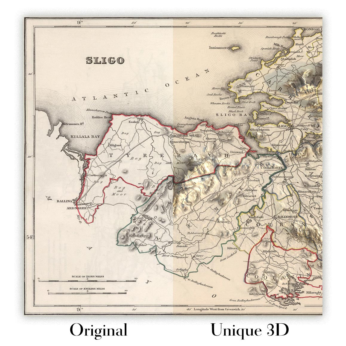
For something truly unique, this map is also available in "Unique 3D", our trademarked process that dramatically transforms the map so that it has a wonderful sense of depth. We combine the original map with detailed topography and elevation data, so that mountains and the terrain really "pop". For more info and examples of 3D maps, check my Unique 3D page.
For most orders, delivery time is about 3 working days. Personalised and customised products take longer, as I have to do the personalisation and send it to you for approval, which usually takes 1 or 2 days.
Please note that very large framed orders usually take longer to make and deliver.
If you need your order to arrive by a certain date, please contact me before you order so that we can find the best way of making sure you get your order in time.
I print and frame maps and artwork in 23 countries around the world. This means your order will be made locally, which cuts down on delivery time and ensures that it won't be damaged during delivery. You'll never pay customs or import duty, and we'll put less CO2 into the air.
All of my maps and art prints are well packaged and sent in a rugged tube if unframed, or surrounded by foam if framed.
I try to send out all orders within 1 or 2 days of receiving your order, though some products (like face masks, mugs and tote bags) can take longer to make.
If you select Express Delivery at checkout your order we will prioritise your order and send it out by 1-day courier (Fedex, DHL, UPS, Parcelforce).
Next Day delivery is also available in some countries (US, UK, Singapore, UAE) but please try to order early in the day so that we can get it sent out on time.
My standard frame is a gallery style black ash hardwood frame. It is simple and quite modern looking. My standard frame is around 20mm (0.8in) wide.
I use super-clear acrylic (perspex/acrylite) for the frame glass. It's lighter and safer than glass - and it looks better, as the reflectivity is lower.
Six standard frame colours are available for free (black, dark brown, dark grey, oak, white and antique gold). Custom framing and mounting/matting is available if you're looking for something else.
Most maps, art and illustrations are also available as a framed canvas. We use matte (not shiny) cotton canvas, stretch it over a sustainably sourced box wood frame, and then 'float' the piece within a wood frame. The end result is quite beautiful, and there's no glazing to get in the way.
All frames are provided "ready to hang", with either a string or brackets on the back. Very large frames will have heavy duty hanging plates and/or a mounting baton. If you have any questions, please get in touch.
See some examples of my framed maps and framed canvas maps.
Alternatively, I can also supply old maps and artwork on canvas, foam board, cotton rag and other materials.
If you want to frame your map or artwork yourself, please read my size guide first.
Alcune delle mie vecchie mappe sono ora disponibili come tele incorniciate. Per favore contattami se desideri ordinare una dimensione che non è disponibile nel mio negozio.
Le vecchie mappe su tela sono un'alternativa interessante alle mappe incorniciate in modo convenzionale. A seconda del tuo gusto personale e dell'arredamento della stanza, le mappe su tela possono "risaltare" un po' di più rispetto a una mappa incorniciata.
My maps are extremely high quality reproductions of original maps.
I source original, rare maps from libraries, auction houses and private collections around the world, restore them at my London workshop, and then use specialist giclée inks and printers to create beautiful maps that look even better than the original.
My maps are printed on acid-free archival matte (not glossy) paper that feels very high quality and almost like card. In technical terms the paper weight/thickness is 10mil/200gsm. It's perfect for framing.
I print with Epson ultrachrome giclée UV fade resistant pigment inks - some of the best inks you can find.
I can also make maps on canvas, cotton rag and other exotic materials.
Learn more about The Unique Maps Co.
Map personalisation
If you're looking for the perfect anniversary or housewarming gift, I can personalise your map to make it truly unique. For example, I can add a short message, or highlight an important location, or add your family's coat of arms.
The options are almost infinite. Please see my map personalisation page for some wonderful examples of what's possible.
To order a personalised map, select "personalise your map" before adding it to your basket.
Get in touch if you're looking for more complex customisations and personalisations.
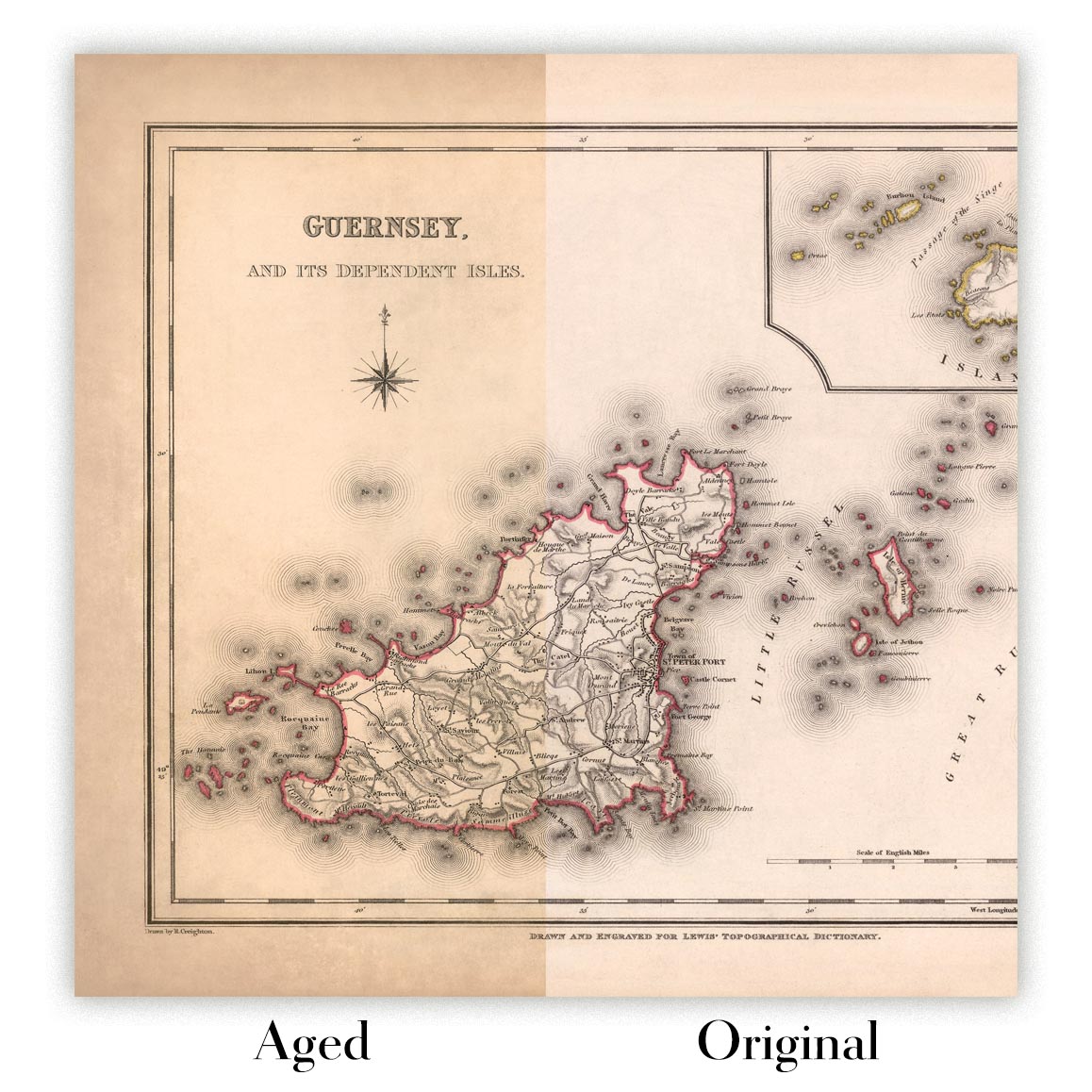
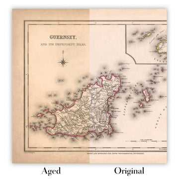
Map ageing
I have been asked hundreds of times over the years by customers if they could buy a map that looks even older.
Well, now you can, by selecting Aged before you add a map to your basket.
All the product photos you see on this page show the map in its Original form. This is what the map looks like today.
If you select Aged, I will age your map by hand, using a special and unique process developed through years of studying old maps, talking to researchers to understand the chemistry of aging paper, and of course... lots of practice!
If you're unsure, stick to the Original colour of the map. If you want something a bit darker and older looking, go for Aged.
Se non sei soddisfatto del tuo ordine per qualsiasi motivo, contattami per un rimborso senza problemi. Si prega di consultare la nostra politica di reso e rimborso per ulteriori informazioni.
Sono molto sicuro che ti piacerà la tua mappa restaurata o la stampa d'arte. Lo faccio dal 1984. Sono un venditore Etsy a 5 stelle. Ho venduto decine di migliaia di mappe e stampe d'arte e ho oltre 5.000 recensioni reali a 5 stelle.
Utilizzo un processo unico per restaurare mappe e opere d'arte che richiede molto tempo e lavoro. Trovare le mappe e le illustrazioni originali può richiedere mesi. Utilizzo tecnologia all'avanguardia e incredibilmente costosa per scannerizzare e restaurarle. Di conseguenza, garantisco che le mie mappe e stampe d'arte siano superiori alle altre - ecco perché posso offrire un rimborso senza problemi.
Quasi tutte le mie mappe e stampe d'arte sembrano fantastiche a grandi dimensioni (200 cm, 6,5 piedi+) e posso anche incorniciarle e consegnarle a te, tramite un corriere speciale per oggetti di grandi dimensioni. Contattami per discutere delle tue esigenze specifiche.
Or try searching for something!


