


Grande Mappa Murale di Londra di Stanford, 1905: Carta Vittoriana di Colore Rosso
Compra 2, Ricevi 1 Gratuito
Se aggiungi 2 articoli al tuo carrello, puoi aggiungere un terzo prodotto gratuitamente.
Questo vale per tutte le mappe e opere d'arte, comprese le opere personalizzate e su misura. Puoi ordinare 3 dello stesso articolo, o 3 articoli diversi.
Questo equivale a uno sconto del 33%, che sarà il maggiore sconto disponibile nel mio negozio quest'anno.
Ti prego di approfittare dell'offerta e di coprire le tue pareti con bellissime mappe e opere d'arte!
Contattami se hai domande.
-
![]() Handmade in the USA
Handmade in the USA

-
FREE worldwide delivery in 2-3 days ⓘ
Free delivery in 2-3 days
Your map should be delivered in 2-3 working days with free delivery, worldwide.
We make maps by hand locally in 23 countries. If you're buying a gift for someone in another country, we will make the map locally to them.
You will never pay import tax or customs duty.
Express delivery is available at checkout which can reduce the delivery time to 1-2 days.
Please note that personalised maps, and larger framed maps, can take longer to produce and deliver.
If you need your order to arrive by a certain date, contact me and we can discuss your options.
-
Complimentary gifting & design advice
ⓘ
Complimentary gifting & design advice
Available almost 24/7 on WhatsApp and email — we usually reply within minutes. We can help you:
- Choose a perfectly personalised gift
- Send a digital gift preview to the recipient
- Pick the ideal size for your wall
- Select the right finish and frame
Quick, friendly advice so you can order with confidence.
For last minute gifts, consider buying a digital gift card. We have over 5,000 maps and art prints to choose from.
-
90-day returns & 5-year guarantee
ⓘ
90 giorni per restituire e ricevere un rimborso
I prodotti possono essere restituiti entro 90 giorni per un rimborso completo, o cambio con un altro prodotto.
Per articoli personalizzati e su misura, potremmo offrirti un credito in negozio o una carta regalo non scadente, poiché non possiamo rivendere ordini personalizzati.
Se hai domande, contattaci. Per ulteriori informazioni, consulta la nostra politica di restituzione e cambio.

This is a museum-grade archival print from the original 1905 map — restored in our workshop and made to order on 220gsm archival matte paper or 400gsm artist's cotton canvas with pigment inks.
Professional framing & free personalisation available
1. Choose a size
2. Frame & personalize your map
Make your map unique with framing, hand-drawn customisation, vintage ageing, pop art text, unique 3D styling and more.


Gift message & custom finish

If you want to add a gift message, or a finish (jigsaw, aluminium board, etc.) that is not available here, please request it in the "order note" when you check out.
Every order is custom made, so if you need the size adjusted slightly, or printed on an unusual material, just let us know. We've done thousands of custom orders over the years, so there's (almost) nothing we can't manage.
You can also contact us before you order, if you prefer!

- Handmade locally. No import duty or tax
- FREE worldwide delivery
- 90-day returns & 5-year product guarantee
- Questions? WhatsApp me any time
Own a piece of history
7,000+ 5 star reviews


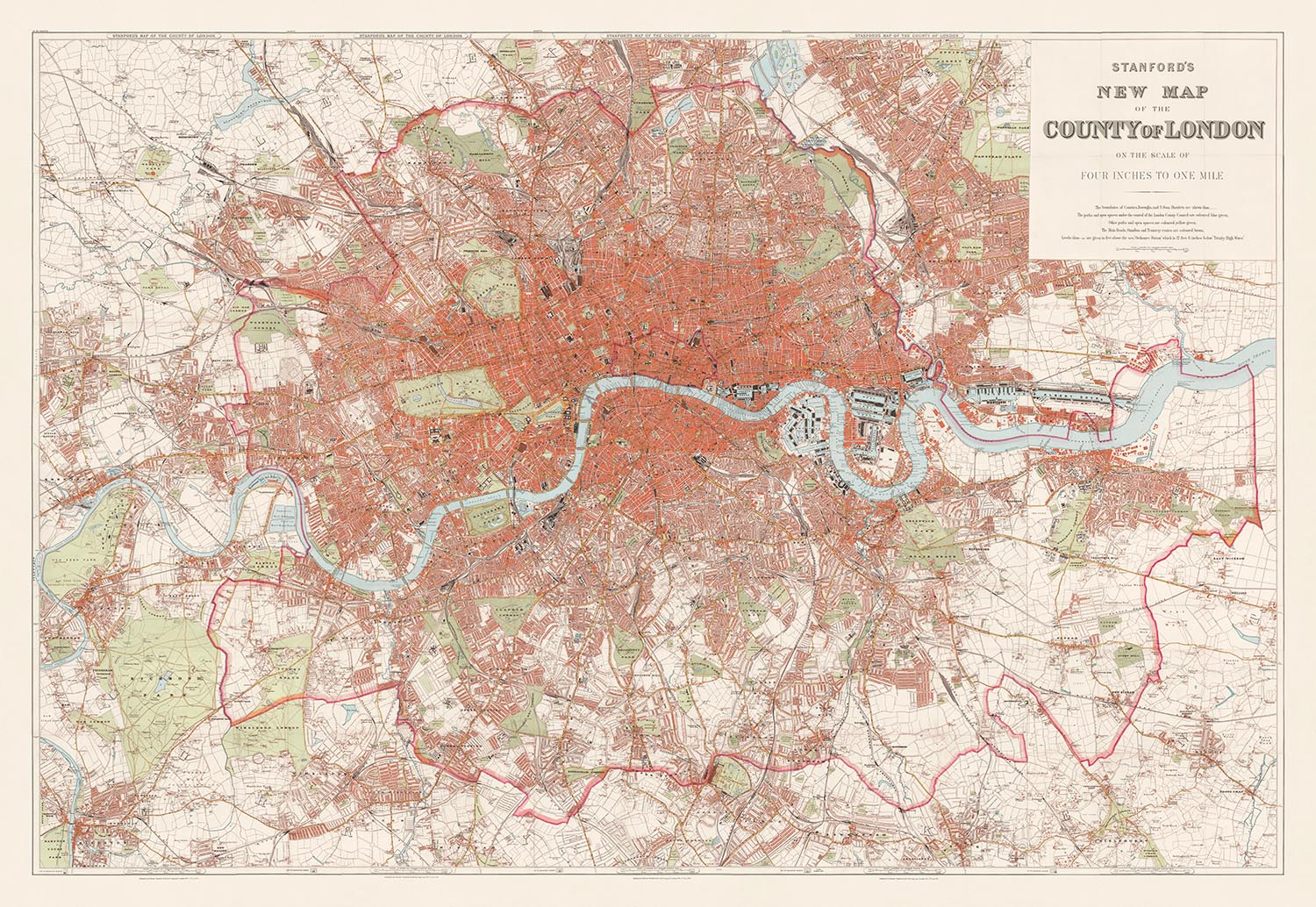
Immergiti nei dettagli intricati dell'era edoardiana con "La Nuova Mappa di Londra di Stanford", un capolavoro realizzato nel 1905 dall'illustre cartografo britannico Edward Stanford.
I colori di questa mappa sono molto simili a una mappa di Londra venduta dalla compagnia di design Timothy Oulton. Possiamo creare un ritaglio più piccolo di questa mappa (lo stesso della mappa di Timothy Oulton) oppure puoi acquistare la mappa di Londra a grandezza naturale che vedi qui.
Rinomato per la sua precisione e attenzione ai dettagli, il lavoro di Stanford cattura l'ampia estensione di Londra in un momento cruciale della sua storia. Questa mappa non solo delinea le strade affollate e i quartieri in espansione, ma funge anche da documento storico, offrendo uno sguardo sul paesaggio urbano di Londra all'inizio del XX secolo. Dalla regale Westminster alle vivaci strade di Camden e alle tranquille distese di Richmond upon Thames, questa mappa è un portale verso il passato, mostrando la città nella sua grandezza vittoriana.
La dedizione di Edward Stanford all'accuratezza è evidente nella rappresentazione dettagliata della mappa dei luoghi significativi che definiscono lo skyline e il paesaggio urbano di Londra. Strutture iconiche come Buckingham Palace, la Cattedrale di St. Paul e il Palazzo di Westminster sono meticolosamente tracciate. Inoltre, la mappa include siti meno conosciuti ma storicamente significativi come il Royal Opera House e il Barbican Centre, rendendola una risorsa inestimabile sia per storici che per appassionati di patrimonio architettonico. L'inclusione del crescente sistema ferroviario e delle nascenti linee della metropolitana di Londra evidenzia i progressi tecnologici dell'epoca e il loro ruolo nella formazione della Londra moderna.
La copertura estesa delle vie d'acqua e degli spazi verdi di Londra aggiunge un ulteriore strato di profondità al suo fascino storico ed estetico. Il percorso tortuoso del fiume Tamigi è messo in evidenza, affiancato da aree recentemente sviluppate lungo le sue rive. Grandi parchi come Hyde Park e Regent's Park sono dettagliati con cura, riflettendo la loro importanza come spazi pubblici nella pianificazione urbana e il loro ruolo come polmoni verdi in mezzo alla densa costruzione della città. Questi elementi rendono la mappa non solo uno strumento di navigazione, ma anche un riflesso della coscienza ambientale di Londra all'inizio del secolo.
La mappa di Stanford funge anche da guida completa alla vasta rete di strade di Londra, dalla vivace Oxford Street alla storica Fleet Street. L'inclusione di tali arterie offre un affascinante sguardo sui centri commerciali e sociali della città, che si sono evoluti nel corso dei decenni ma mantengono ancora le loro rotte fondamentali come descritto in questo scatto del 1905. Per chiunque sia interessato allo sviluppo urbano, questa mappa fornisce una comprensione fondamentale di come le famose strade e luoghi di Londra si siano trasformati e cosa sia rimasto costante attraverso i tempi di cambiamento.
Infine, "La Nuova Mappa di Londra di Stanford" è più di una semplice creazione cartografica; è un'opera d'arte e un oggetto da collezione per coloro che apprezzano le mappe come porte verso i mondi che rappresentano. Lo stile vittoriano tradizionale, con il suo focus sia sull'appeal estetico che sull'accuratezza funzionale, rende questa mappa un pezzo distinto tra le opere prolifiche di Stanford. Per collezionisti, storici e ammiratori di Londra, questa mappa non è semplicemente una rappresentazione geografica; è un ricco arazzo intrecciato di storia, architettura e cultura, catturato in un momento in cui Londra stava rapidamente entrando nell'età moderna.
Strade e vie su questa mappa
- Abbey Road
- Adelaide Road
- Aldersgate Street
- Aldgate
- Baker Street
- Bayswater Road
- Bishopsgate Street
- Blackfriars Road
- Bow Road
- Brixton Road
- Broad Street
- Brompton Road
- Buckingham Palace Road
- Cambridge Road
- Camden Road
- Cannon Street
- Chancery Lane
- Cheapside
- Charing Cross Road
- City Road
- Commercial Road
- Cornhill
- Coventry Street
- Cranbourn Street
- Edgware Road
- Euston Road
- Farringdon Street
- Fleet Street
- Great Eastern Street
- Great Portland Street
- Great Queen Street
- Great Russell Street
- Great Smith Street
- Great Western Road
- Grosvenor Place
- Guilford Street
- Hammersmith Road
- Hampstead Road
- Hanover Square
- Haymarket
- High Holborn
- Holborn
- Holloway Road
- Hyde Park Street
- Kensington Gore
- Kensington Road
- Kent Road
- King Street
- Kingsland Road
- Knightsbridge
- Leadenhall Street
- Leicester Square
- Lincoln's Inn Fields
- Liverpool Street
- Lombard Street
- Long Acre
- Ludgate Hill
- Marylebone Lane
- Mile End Road
- Moorgate Street
- New Bond Street
- New Oxford Street
- Old Bailey
- Old Bond Street
- Oxford Street
- Park Lane
- Piccadilly
- Portland Place
- Praed Street
- Prince of Wales Road
- Queen Victoria Street
- Regent Street
- St. Giles High Street
- St. James's Street
- St. John Street
- St. Martin's Lane
- St. Paul's Churchyard
- Strand
- Theobald's Road
- Tottenham Court Road
- Trafalgar Square
- Upper Street
- Walworth Road
- Warwick Square
- Waterloo Road
- Watling Street
- Wellington Street
- Whitechapel Road
- Wigmore Street
- Wood Street
Caratteristiche e monumenti notevoli
- La Torre di Londra
- La Cattedrale di St. Paul
- Il Palazzo di Buckingham
- Le Case del Parlamento
- Il Museo Britannico
- Il Museo di Storia Naturale
- Il Museo della Scienza
- Il Museo Victoria e Albert
- La Galleria Tate
- La Galleria Nazionale
- Il Royal Albert Hall
- Il Royal Opera House
- Il Leadenhall Building
- Il Lloyd's Building
- La St. Mary Axe
- Il Serpentine
- Il Round Pond
- Il Canale di Regent
- Il Canale Grand Union
- Il Fiume Tamigi
- Hyde Park
- I Giardini di Kensington
- Green Park
- St. James's Park
- Il Parco di Regent
- Primrose Hill
- Hampstead Heath
- Foresta di Epping
- Foresta di Hainault
- Wimbledon Common
- Richmond Park
- Bushy Park
- Hampton Court Park
- La Metropolitana di Londra
- La M25
- La A406 North Circular Road
- La A232 South Circular Road
Contesto storico e di design
- Nome della mappa: La Nuova Mappa di Londra di Stanford
- Data di creazione: 1905
- Cartografo/editore: Edward Stanford
- Copre un'ampia area che include il Centro di Londra
- Stile vittoriano tradizionale con un focus su dettagli e accuratezza
- Sfondo chiaro e edifici colorati di rosso per abbinarsi alla mappa simile di Londra di Timothy Oulton
- Documento storico prezioso che fornisce un'istantanea di Londra all'inizio del XX secolo
Per favore, controlla attentamente le immagini per assicurarti che una certa città o luogo sia mostrato su questa mappa. Puoi anche contattarci e chiedere di controllare la mappa per te.
Questa è una mappa molto grande che deve essere ordinata in una grande dimensione, in modo da poter distinguere facilmente tutti i dettagli.
Questa mappa appare sorprendente in dimensioni fino a qualche metro. Se stai cercando una mappa più grande, per favore contattaci.
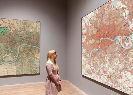
Il modello nelle immagini dell'inserzione tiene la versione di questa mappa 24x36in (60x90cm).
La quinta immagine dell'inserzione mostra un esempio del mio servizio di personalizzazione della mappa.
Se stai cercando qualcosa di leggermente diverso, dai un'occhiata alla mia collezione dei migliori mappe antiche per vedere se qualcosa attira la tua attenzione.
Per favore contattami per verificare se una certa posizione, punto di riferimento o caratteristica è mostrata su questa mappa.
Questo sarebbe un meraviglioso regalo per un compleanno, Natale, Festa del Papà, addio al lavoro, anniversario o inaugurazione della casa per qualcuno delle aree coperte da questa mappa.
Questa mappa è disponibile come stampa giclée su carta opaca archiviata senza acidi, oppure puoi acquistarla incorniciata. La cornice è una semplice cornice nera che si adatta alla maggior parte degli stili. Per favore, contattaci se desideri un colore o un materiale di cornice diverso. Le mie cornici sono dotate di un acrilico (perspex/acrylite) di grado museale super chiaro, che è significativamente meno riflettente del vetro, più sicuro e arriverà sempre in perfette condizioni.
This map is also available as a float framed canvas, sometimes known as a shadow gap framed canvas or canvas floater. The map is printed on artist's cotton canvas and then stretched over a handmade box frame. We then "float" the canvas inside a wooden frame, which is available in a range of colours (black, dark brown, oak, antique gold and white). This is a wonderful way to present a map without glazing in front. See some examples of float framed canvas maps and explore the differences between my different finishes.
For something truly unique, this map is also available in "Unique 3D", our trademarked process that dramatically transforms the map so that it has a wonderful sense of depth. We combine the original map with detailed topography and elevation data, so that mountains and the terrain really "pop". For more info and examples of 3D maps, check my Unique 3D page.
For most orders, delivery time is about 3 working days. Personalised and customised products take longer, as I have to do the personalisation and send it to you for approval, which usually takes 1 or 2 days.
Please note that very large framed orders usually take longer to make and deliver.
If you need your order to arrive by a certain date, please contact me before you order so that we can find the best way of making sure you get your order in time.
I print and frame maps and artwork in 23 countries around the world. This means your order will be made locally, which cuts down on delivery time and ensures that it won't be damaged during delivery. You'll never pay customs or import duty, and we'll put less CO2 into the air.
All of my maps and art prints are well packaged and sent in a rugged tube if unframed, or surrounded by foam if framed.
I try to send out all orders within 1 or 2 days of receiving your order, though some products (like face masks, mugs and tote bags) can take longer to make.
If you select Express Delivery at checkout your order we will prioritise your order and send it out by 1-day courier (Fedex, DHL, UPS, Parcelforce).
Next Day delivery is also available in some countries (US, UK, Singapore, UAE) but please try to order early in the day so that we can get it sent out on time.
My standard frame is a gallery style black ash hardwood frame. It is simple and quite modern looking. My standard frame is around 20mm (0.8in) wide.
I use super-clear acrylic (perspex/acrylite) for the frame glass. It's lighter and safer than glass - and it looks better, as the reflectivity is lower.
Six standard frame colours are available for free (black, dark brown, dark grey, oak, white and antique gold). Custom framing and mounting/matting is available if you're looking for something else.
Most maps, art and illustrations are also available as a framed canvas. We use matte (not shiny) cotton canvas, stretch it over a sustainably sourced box wood frame, and then 'float' the piece within a wood frame. The end result is quite beautiful, and there's no glazing to get in the way.
All frames are provided "ready to hang", with either a string or brackets on the back. Very large frames will have heavy duty hanging plates and/or a mounting baton. If you have any questions, please get in touch.
See some examples of my framed maps and framed canvas maps.
Alternatively, I can also supply old maps and artwork on canvas, foam board, cotton rag and other materials.
If you want to frame your map or artwork yourself, please read my size guide first.
Alcune delle mie vecchie mappe sono ora disponibili come tele incorniciate. Per favore contattami se desideri ordinare una dimensione che non è disponibile nel mio negozio.
Le vecchie mappe su tela sono un'alternativa interessante alle mappe incorniciate in modo convenzionale. A seconda del tuo gusto personale e dell'arredamento della stanza, le mappe su tela possono "risaltare" un po' di più rispetto a una mappa incorniciata.
My maps are extremely high quality reproductions of original maps.
I source original, rare maps from libraries, auction houses and private collections around the world, restore them at my London workshop, and then use specialist giclée inks and printers to create beautiful maps that look even better than the original.
My maps are printed on acid-free archival matte (not glossy) paper that feels very high quality and almost like card. In technical terms the paper weight/thickness is 10mil/200gsm. It's perfect for framing.
I print with Epson ultrachrome giclée UV fade resistant pigment inks - some of the best inks you can find.
I can also make maps on canvas, cotton rag and other exotic materials.
Learn more about The Unique Maps Co.
Map personalisation
If you're looking for the perfect anniversary or housewarming gift, I can personalise your map to make it truly unique. For example, I can add a short message, or highlight an important location, or add your family's coat of arms.
The options are almost infinite. Please see my map personalisation page for some wonderful examples of what's possible.
To order a personalised map, select "personalise your map" before adding it to your basket.
Get in touch if you're looking for more complex customisations and personalisations.
Map ageing
I have been asked hundreds of times over the years by customers if they could buy a map that looks even older.
Well, now you can, by selecting Aged before you add a map to your basket.
All the product photos you see on this page show the map in its Original form. This is what the map looks like today.
If you select Aged, I will age your map by hand, using a special and unique process developed through years of studying old maps, talking to researchers to understand the chemistry of aging paper, and of course... lots of practice!
If you're unsure, stick to the Original colour of the map. If you want something a bit darker and older looking, go for Aged.
Se non sei soddisfatto del tuo ordine per qualsiasi motivo, contattami per un rimborso senza problemi. Si prega di consultare la nostra politica di reso e rimborso per ulteriori informazioni.
Sono molto sicuro che ti piacerà la tua mappa restaurata o la stampa d'arte. Lo faccio dal 1984. Sono un venditore Etsy a 5 stelle. Ho venduto decine di migliaia di mappe e stampe d'arte e ho oltre 5.000 recensioni reali a 5 stelle.
Utilizzo un processo unico per restaurare mappe e opere d'arte che richiede molto tempo e lavoro. Trovare le mappe e le illustrazioni originali può richiedere mesi. Utilizzo tecnologia all'avanguardia e incredibilmente costosa per scannerizzare e restaurarle. Di conseguenza, garantisco che le mie mappe e stampe d'arte siano superiori alle altre - ecco perché posso offrire un rimborso senza problemi.
Quasi tutte le mie mappe e stampe d'arte sembrano fantastiche a grandi dimensioni (200 cm, 6,5 piedi+) e posso anche incorniciarle e consegnarle a te, tramite un corriere speciale per oggetti di grandi dimensioni. Contattami per discutere delle tue esigenze specifiche.
Or try searching for something!


