


Mapa muy grande de Texas de Hoffman & Walker, 1965: Histórico, Álamo, Galveston, Chisholm Trail, Exploradores españoles
La oferta del coleccionista
Elija dos obras elegibles y obtenga un 20 % de descuento en ambas. Elija tres y la de menor precio será gratuita, con un ahorro máximo del 33 %.
Combine y mezcle mapas estándar elegibles y reproducciones de bellas artes. No se requiere código; la oferta se aplica automáticamente al finalizar la compra.
Se incluyen las configuraciones estándar hechas por encargo. Quedan excluidos los tamaños a medida, los diseños personalizados y los trabajos por encargo.
¿Necesita entrega en diferentes direcciones? Contáctenos antes de realizar el pedido.La oferta del coleccionista
Elija dos obras elegibles y obtenga un 20 % de descuento en ambas. Elija tres y la de menor precio será gratuita, con un ahorro máximo del 33 %.
Combine y mezcle mapas estándar elegibles y reproducciones de bellas artes. No se requiere código; la oferta se aplica automáticamente al finalizar la compra.
Se incluyen las configuraciones estándar hechas por encargo. Quedan excluidos los tamaños a medida, los diseños personalizados y los trabajos por encargo.
¿Necesita entrega en diferentes direcciones? Contáctenos antes de realizar el pedido. Restaurado en Londres • Hecho en the USA

Restaurado a partir del mapa original de 1965 e impreso en calidad museo. Leer la historia detrás de este mapa
Choose your size
Choose your finish


(Más información)
Mensaje de regalo y acabado personalizado

Si deseas agregar un mensaje de regalo, o un acabado (rompecabezas, tablero de aluminio, etc.) que no esté disponible aquí, por favor solicítalo en la "nota del pedido" cuando realices la compra.
Cada pedido es hecho a medida, así que si necesitas que el tamaño se ajuste ligeramente, o que se imprima en un material inusual, háznoslo saber. Hemos realizado miles de pedidos personalizados a lo largo de los años, así que hay (casi) nada que no podamos gestionar.
También puedes contactarnos antes de hacer tu pedido, ¡si lo prefieres!

- Hecho localmente. Entrega segura
- Sin aranceles ni cargos ocultos
- ¿Necesitas ayuda? Llámanos o mensaje por WhatsApp
Own a piece of history
8,000+ five-star reviews


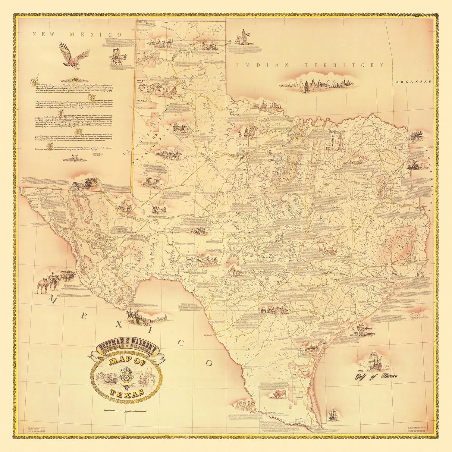
Adéntrese en el célebre pasado del Estado de la Estrella Solitaria con el "Pictorial Historical Map of Texas" de Hoffman & Walker,...
Seguir leyendoAdéntrese en el célebre pasado del Estado de la Estrella Solitaria con el "Pictorial Historical Map of Texas" de Hoffman & Walker, elaborado en 1965. Este extraordinario mapa es más que un artefacto cartográfico: es un recorrido visual por siglos de historia de Texas, elegantemente ilustrado y ricamente anotado. Desde el primer desembarco europeo registrado de Álvar Núñez Cabeza de Vaca cerca de Galveston Island en 1528, hasta los acontecimientos transformadores de principios del siglo XX, este mapa entreteje el dramático tapiz de exploración, conflicto y evolución cultural que dio forma a Texas.
Cada centímetro de este mapa rebosa de detalle histórico. Los hitos más importantes se representan vívidamente, incluida la legendaria Batalla de San Jacinto, la heroica defensa del Álamo en San Antonio y la devastación causada por el huracán de Galveston de 1900, conocido como la "Big Storm". Las rutas de los exploradores españoles y los primeros colonos se trazan con precisión, mientras que las emblemáticas conducciones de ganado y el célebre Chisholm Trail serpentean por el paisaje, capturando el espíritu de la frontera. A estas narrativas visuales se suman ilustraciones de misiones, fuertes y primeros asentamientos, que ofrecen una visión integral de los años formativos de Texas.
Lo que distingue a este mapa es su atractivo estilo pictórico, que da vida no solo a la geografía, sino también a las personas y los acontecimientos que definieron Texas. Retratos de figuras históricas, representaciones de tribus nativas americanas y de primeros puestos militares y monumentos arquitectónicos crean una sensación de inmediatez y conexión con el pasado. La riqueza temática del mapa se ve reforzada además por la inclusión de los hitos agrícolas, industriales y culturales de Texas, desde los primeros descubrimientos petroleros hasta el auge de grandes ciudades como Houston, Dallas y Austin.
El valor educativo del mapa se complementa con su atractivo estético. Cada anotación e ilustración está meticulosamente dispuesta, invitando al espectador a explorar las batallas significativas, las ciudades históricas y los acontecimientos transformadores que se desarrollaron en todo Texas. La interacción entre el detalle artístico y la exactitud histórica convierte a este mapa en una pieza de conversación excepcional, ideal para quienes aprecian tanto el arte de la cartografía como la profundidad de la narrativa histórica.
Para coleccionistas, historiadores o cualquier persona cautivada por la saga de Texas, este mapa ofrece una ventana única al extraordinario recorrido del estado. Sirve como homenaje a la resiliencia, la diversidad y el legado perdurable de Texas, capturando la esencia de su gente, sus paisajes y su papel fundamental en la historia de Estados Unidos. Exhibir este mapa no es solo un acto decorativo: es una invitación a revivir los triunfos y las pruebas que forjaron la identidad de Texas.
Lugares en este mapa
- Galveston Island
- San Antonio (incluido el Álamo)
- Houston
- Austin
- Dallas
- Fort Worth
- El Paso
- Corpus Christi
- Laredo
- Amarillo
- Waco
- Brownsville
- San Jacinto (lugar de la batalla)
- Nacogdoches
- Goliad
- Gonzales
- Beaumont
- Abilene
- Lubbock
- Tyler
Características y lugares destacados notables
- Ilustración y etiqueta del desembarco de Álvar Núñez Cabeza de Vaca cerca de Galveston Island en 1528
- Representación del huracán "Big Storm" en Galveston en 1900
- El Álamo en San Antonio, ilustrado y señalado de forma destacada
- Batalla de San Jacinto, claramente marcada e ilustrada
- Ruta de los exploradores españoles y los primeros colonos
- Representación de las primeras misiones españolas
- Ilustraciones de las rutas de arrear ganado y del Chisholm Trail
- Representación de tribus y asentamientos de nativos americanos
- Ilustración de los primeros fuertes y puestos militares
- Representación de los acontecimientos de la Revolución de Texas
- Ilustración de la época de la República de Texas
- Representación de los primeros ferrocarriles y rutas de diligencias
- Ilustraciones de figuras históricas destacadas en la historia de Texas
- Ilustraciones de arquitectura y monumentos históricos
- Representación de los primeros descubrimientos petroleros y lugares de perforación
- Ilustraciones relacionadas con la historia agrícola de Texas
- Representación de los primeros asentamientos y esfuerzos de colonización
- Ilustraciones de la vida en la frontera y de los asentamientos pioneros
- Representación de ríos significativos y rasgos geográficos
- Ilustraciones de acontecimientos históricos relacionados con la independencia de Texas
- Representación de la exploración marítima temprana y de los naufragios
- Ilustraciones de banderas históricas asociadas con la historia de Texas
- Representación de batallas y escaramuzas significativas
- Ilustraciones de medios históricos de transporte (carretas, diligencias, ferrocarriles)
- Representación de pueblos y ciudades históricamente significativos
- Ilustraciones de la fauna y los recursos naturales históricamente significativos para Texas
- Representación de las primeras instituciones educativas y escuelas
- Ilustraciones de misiones y iglesias religiosas históricas
- Representación de rutas comerciales y del comercio históricos
- Ilustraciones de acontecimientos y tradiciones culturales históricas
Contexto histórico y de diseño
- Nombre del mapa: Mapa histórico pictórico de Texas
- Fecha de creación: 1965
- Cartógrafo/Editor: Hoffman & Walker
- Hoffman & Walker eran conocidos por crear mapas detallados, pictóricos y temáticos que narran visualmente acontecimientos históricos y el patrimonio cultural
- El mapa presenta rótulos e ilustraciones históricas desde la llegada del explorador español Álvar Núñez Cabeza de Vaca en 1528, a través de acontecimientos históricos significativos hasta el huracán de Galveston ("Gran Tormenta") de 1900
- El mapa se centra en acontecimientos históricos, exploración, colonización, batallas y monumentos culturales e históricos significativos de la historia de Texas
- Principalmente el estado de Texas, EE. UU., con estados circundantes y México parcialmente visibles para contextualizar
- El mapa es pictórico y temático, con ilustraciones detalladas, anotaciones históricas y un estilo vintage y artístico típico de los mapas históricos de mediados del siglo XX
- El mapa captura visualmente momentos y monumentos clave de la historia de Texas, ofreciendo valor educativo y una visión cultural del pasado de Texas
Por favor, revisa cuidadosamente las imágenes para asegurarte de que se muestra un pueblo o lugar específico en este mapa. También puedes ponerte en contacto con nosotros y pedirnos que comprobemos el mapa por ti.
Este es un mapa muy grande que debe pedirse en un tamaño grande, para que puedas apreciar fácilmente todos los detalles.
Este mapa se ve increíble en tamaños de hasta 100in (250cm). Si buscas un mapa más grande, por favor ponte en contacto.
El modelo en las imágenes del anuncio sostiene la versión de 16x16in (40x40cm) de este mapa.
La quinta imagen del anuncio muestra un ejemplo de mi servicio de personalización de mapas.
Si buscas algo ligeramente diferente, echa un vistazo a mi colección de los mejores mapas antiguos para ver si algo más llama su atención.
Por favor, contácteme para comprobar si una determinada ubicación, hito o elemento aparece en este mapa.
Esto sería un maravilloso regalo de cumpleaños, Navidad, Día del Padre, despedida laboral, aniversario o inauguración de casa para alguien de las zonas cubiertas por este mapa.
Este mapa está disponible como impresión giclée sobre papel mate de archivo libre de ácido, o puede adquirirlo enmarcado. El marco es negro, elegante y sencillo, y se adapta a la mayoría de las estéticas. Póngase en contacto si desea un color o material de marco diferente. Mis marcos están acristalados con acrílico de grado museo de gran transparencia (perspex/acrylite), que es significativamente menos reflectante que el vidrio, más seguro y siempre llegará en perfectas condiciones.
This map is also available as a float framed canvas, sometimes known as a shadow gap framed canvas or canvas floater. The map is printed on artist's cotton canvas and then stretched over a handmade box frame. We then "float" the canvas inside a wooden frame, which is available in a range of colours (black, dark brown, oak, antique gold and white). This is a wonderful way to present a map without glazing in front. See some examples of float framed canvas maps and explore the differences between my different finishes.
For something truly unique, this map is also available in "Unique 3D", our trademarked process that dramatically transforms the map so that it has a wonderful sense of depth. We combine the original map with detailed topography and elevation data, so that mountains and the terrain really "pop". For more info and examples of 3D maps, check my Unique 3D page.
Adéntrese en el célebre pasado del Estado de la Estrella Solitaria con el "Pictorial Historical Map of Texas" de Hoffman & Walker, elaborado en 1965. Este extraordinario mapa es más que un artefacto cartográfico: es un recorrido visual por siglos de historia de Texas, elegantemente ilustrado y ricamente anotado. Desde el primer desembarco europeo registrado de Álvar Núñez Cabeza de Vaca cerca de Galveston Island en 1528, hasta los acontecimientos transformadores de principios del siglo XX, este mapa entreteje el dramático tapiz de exploración, conflicto y evolución cultural que dio forma a Texas.
Cada centímetro de este mapa rebosa de detalle histórico. Los hitos más importantes se representan vívidamente, incluida la legendaria Batalla de San Jacinto, la heroica defensa del Álamo en San Antonio y la devastación causada por el huracán de Galveston de 1900, conocido como la "Big Storm". Las rutas de los exploradores españoles y los primeros colonos se trazan con precisión, mientras que las emblemáticas conducciones de ganado y el célebre Chisholm Trail serpentean por el paisaje, capturando el espíritu de la frontera. A estas narrativas visuales se suman ilustraciones de misiones, fuertes y primeros asentamientos, que ofrecen una visión integral de los años formativos de Texas.
Lo que distingue a este mapa es su atractivo estilo pictórico, que da vida no solo a la geografía, sino también a las personas y los acontecimientos que definieron Texas. Retratos de figuras históricas, representaciones de tribus nativas americanas y de primeros puestos militares y monumentos arquitectónicos crean una sensación de inmediatez y conexión con el pasado. La riqueza temática del mapa se ve reforzada además por la inclusión de los hitos agrícolas, industriales y culturales de Texas, desde los primeros descubrimientos petroleros hasta el auge de grandes ciudades como Houston, Dallas y Austin.
El valor educativo del mapa se complementa con su atractivo estético. Cada anotación e ilustración está meticulosamente dispuesta, invitando al espectador a explorar las batallas significativas, las ciudades históricas y los acontecimientos transformadores que se desarrollaron en todo Texas. La interacción entre el detalle artístico y la exactitud histórica convierte a este mapa en una pieza de conversación excepcional, ideal para quienes aprecian tanto el arte de la cartografía como la profundidad de la narrativa histórica.
Para coleccionistas, historiadores o cualquier persona cautivada por la saga de Texas, este mapa ofrece una ventana única al extraordinario recorrido del estado. Sirve como homenaje a la resiliencia, la diversidad y el legado perdurable de Texas, capturando la esencia de su gente, sus paisajes y su papel fundamental en la historia de Estados Unidos. Exhibir este mapa no es solo un acto decorativo: es una invitación a revivir los triunfos y las pruebas que forjaron la identidad de Texas.
Lugares en este mapa
- Galveston Island
- San Antonio (incluido el Álamo)
- Houston
- Austin
- Dallas
- Fort Worth
- El Paso
- Corpus Christi
- Laredo
- Amarillo
- Waco
- Brownsville
- San Jacinto (lugar de la batalla)
- Nacogdoches
- Goliad
- Gonzales
- Beaumont
- Abilene
- Lubbock
- Tyler
Características y lugares destacados notables
- Ilustración y etiqueta del desembarco de Álvar Núñez Cabeza de Vaca cerca de Galveston Island en 1528
- Representación del huracán "Big Storm" en Galveston en 1900
- El Álamo en San Antonio, ilustrado y señalado de forma destacada
- Batalla de San Jacinto, claramente marcada e ilustrada
- Ruta de los exploradores españoles y los primeros colonos
- Representación de las primeras misiones españolas
- Ilustraciones de las rutas de arrear ganado y del Chisholm Trail
- Representación de tribus y asentamientos de nativos americanos
- Ilustración de los primeros fuertes y puestos militares
- Representación de los acontecimientos de la Revolución de Texas
- Ilustración de la época de la República de Texas
- Representación de los primeros ferrocarriles y rutas de diligencias
- Ilustraciones de figuras históricas destacadas en la historia de Texas
- Ilustraciones de arquitectura y monumentos históricos
- Representación de los primeros descubrimientos petroleros y lugares de perforación
- Ilustraciones relacionadas con la historia agrícola de Texas
- Representación de los primeros asentamientos y esfuerzos de colonización
- Ilustraciones de la vida en la frontera y de los asentamientos pioneros
- Representación de ríos significativos y rasgos geográficos
- Ilustraciones de acontecimientos históricos relacionados con la independencia de Texas
- Representación de la exploración marítima temprana y de los naufragios
- Ilustraciones de banderas históricas asociadas con la historia de Texas
- Representación de batallas y escaramuzas significativas
- Ilustraciones de medios históricos de transporte (carretas, diligencias, ferrocarriles)
- Representación de pueblos y ciudades históricamente significativos
- Ilustraciones de la fauna y los recursos naturales históricamente significativos para Texas
- Representación de las primeras instituciones educativas y escuelas
- Ilustraciones de misiones y iglesias religiosas históricas
- Representación de rutas comerciales y del comercio históricos
- Ilustraciones de acontecimientos y tradiciones culturales históricas
Contexto histórico y de diseño
- Nombre del mapa: Mapa histórico pictórico de Texas
- Fecha de creación: 1965
- Cartógrafo/Editor: Hoffman & Walker
- Hoffman & Walker eran conocidos por crear mapas detallados, pictóricos y temáticos que narran visualmente acontecimientos históricos y el patrimonio cultural
- El mapa presenta rótulos e ilustraciones históricas desde la llegada del explorador español Álvar Núñez Cabeza de Vaca en 1528, a través de acontecimientos históricos significativos hasta el huracán de Galveston ("Gran Tormenta") de 1900
- El mapa se centra en acontecimientos históricos, exploración, colonización, batallas y monumentos culturales e históricos significativos de la historia de Texas
- Principalmente el estado de Texas, EE. UU., con estados circundantes y México parcialmente visibles para contextualizar
- El mapa es pictórico y temático, con ilustraciones detalladas, anotaciones históricas y un estilo vintage y artístico típico de los mapas históricos de mediados del siglo XX
- El mapa captura visualmente momentos y monumentos clave de la historia de Texas, ofreciendo valor educativo y una visión cultural del pasado de Texas
Por favor, revisa cuidadosamente las imágenes para asegurarte de que se muestra un pueblo o lugar específico en este mapa. También puedes ponerte en contacto con nosotros y pedirnos que comprobemos el mapa por ti.
Este es un mapa muy grande que debe pedirse en un tamaño grande, para que puedas apreciar fácilmente todos los detalles.
Este mapa se ve increíble en tamaños de hasta 100in (250cm). Si buscas un mapa más grande, por favor ponte en contacto.
El modelo en las imágenes del anuncio sostiene la versión de 16x16in (40x40cm) de este mapa.
La quinta imagen del anuncio muestra un ejemplo de mi servicio de personalización de mapas.
Si buscas algo ligeramente diferente, echa un vistazo a mi colección de los mejores mapas antiguos para ver si algo más llama su atención.
Por favor, contácteme para comprobar si una determinada ubicación, hito o elemento aparece en este mapa.
Esto sería un maravilloso regalo de cumpleaños, Navidad, Día del Padre, despedida laboral, aniversario o inauguración de casa para alguien de las zonas cubiertas por este mapa.
Este mapa está disponible como impresión giclée sobre papel mate de archivo libre de ácido, o puede adquirirlo enmarcado. El marco es negro, elegante y sencillo, y se adapta a la mayoría de las estéticas. Póngase en contacto si desea un color o material de marco diferente. Mis marcos están acristalados con acrílico de grado museo de gran transparencia (perspex/acrylite), que es significativamente menos reflectante que el vidrio, más seguro y siempre llegará en perfectas condiciones.
This map is also available as a float framed canvas, sometimes known as a shadow gap framed canvas or canvas floater. The map is printed on artist's cotton canvas and then stretched over a handmade box frame. We then "float" the canvas inside a wooden frame, which is available in a range of colours (black, dark brown, oak, antique gold and white). This is a wonderful way to present a map without glazing in front. See some examples of float framed canvas maps and explore the differences between my different finishes.
For something truly unique, this map is also available in "Unique 3D", our trademarked process that dramatically transforms the map so that it has a wonderful sense of depth. We combine the original map with detailed topography and elevation data, so that mountains and the terrain really "pop". For more info and examples of 3D maps, check my Unique 3D page.
Many of our maps and art prints are chosen as thoughtful gifts for homes, offices, studies and meaningful places.
Choose a framed option for the easiest ready-to-hang gift, or choose an unframed print if the recipient may prefer to select their own frame.
We make orders locally in 23 countries around the world, so gifts can often be produced close to the recipient. This helps them arrive faster, travel more safely, and avoid customs or import duty surprises.
- We can deliver directly to the recipient
- Framed pieces arrive ready to hang
- Unframed prints are carefully packed in a strong protective tube
- Almost every order is made locally, for faster, safer gifting
- 90-day returns give the recipient time to decide
If you are not sure what to choose, please contact us. We can help you pick the right map, size, finish or delivery option.
Para la mayoría de los pedidos, el tiempo de entrega es de aproximadamente 3 días laborables. Los productos personalizados y a medida tardan más, ya que tengo que hacer la personalización y enviártelo para su aprobación, lo cual suele tardar 1 o 2 días.
Tenga en cuenta que los pedidos enmarcados muy grandes suelen tardar más en fabricarse y entregarse.
Si necesitas que tu pedido llegue para una fecha determinada, por favor contáctame antes de hacer el pedido para que podamos encontrar la mejor manera de asegurarnos de que recibas tu pedido a tiempo.
Imprimo y enmarco mapas y obras de arte en 23 países alrededor del mundo. Esto significa que tu pedido se fabricará localmente, lo que reduce el tiempo de entrega y asegura que no se dañe durante el envío. Nunca pagarás aranceles de aduana o impuestos de importación, y pondremos menos CO2 en el aire.
Todos mis mapas y impresiones artísticas están bien empaquetados y enviados en un tubo resistente si no están enmarcados, o rodeados de espuma si están enmarcados.
Intento enviar todos los pedidos dentro de 1 o 2 días después de recibir tu pedido, aunque algunos productos (como mascarillas, tazas y bolsas de tela) pueden tardar más en fabricarse.
Si seleccionas Entrega Exprés al finalizar la compra, priorizaremos tu pedido y lo enviaremos por mensajería de 1 día (Fedex, DHL, UPS, Parcelforce).
La entrega al día siguiente también está disponible en algunos países (EE. UU., Reino Unido, Singapur, EAU), pero por favor intenta hacer tu pedido temprano en el día para que podamos enviarlo a tiempo.
Mi marco estándar es un marco de madera de fresno negro estilo galería. Es simple y tiene un aspecto bastante moderno. Mi marco estándar tiene alrededor de 20 mm (0.8 in) de ancho.
Utilizo acrílico super claro (perspex/acrylite) para el vidrio del marco. Es más ligero y seguro que el vidrio, y se ve mejor, ya que la reflectividad es menor.
Seis colores de marco estándar están disponibles de forma gratuita (negro, marrón oscuro, gris oscuro, roble, blanco y oro antiguo).El enmarcado y montaje/matizado personalizado está disponible si buscas algo diferente.
La mayoría de los mapas, arte e ilustraciones también están disponibles como un lienzo enmarcado. Utilizamos lienzo de algodón mate (no brillante), lo estiramos sobre un marco de madera de caja de origen sostenible, y luego 'flotamos' la pieza dentro de un marco de madera. El resultado final es bastante hermoso, y no hay cristal que se interponga.
Todos los marcos se proporcionan "listos para colgar", con una cuerda o soportes en la parte posterior. Los marcos muy grandes tendrán placas de colgar de alta resistencia y/o un listón de montaje. Si tienes alguna pregunta, por favor ponte en contacto.
Mira algunos ejemplos de mis mapas enmarcados y mapas en lienzo enmarcados.
Alternativamente, también puedo proporcionar mapas antiguos y obras de arte en lienzo, tablero de espuma, papel de algodón y otros materiales.
Si deseas enmarcar tu mapa o obra de arte tú mismo, por favor lee mi guía de tamaños primero.
Mis mapas son reproducciones de mapas originales de altísima calidad.
Obtengo mapas originales y raros de bibliotecas, casas de subastas y colecciones privadas de todo el mundo, los restauro en mi taller de Londres y luego uso tintas e impresoras giclée especializadas para crear hermosos mapas que lucen incluso mejor que el original.
Mis mapas están impresos en papel de archivo mate (no brillante) sin ácido que se siente de muy alta calidad y casi como una tarjeta. En términos técnicos, el peso/grosor del papel es de 10 mil/200 g/m². Es perfecto para enmarcar.
Imprimo con tintas pigmentadas Epson ultrachrome giclée UV resistentes a la decoloración, algunas de las mejores tintas que puedes encontrar.
yo también puedo hacer mapas sobre lienzo, trapo de algodón y otros materiales exóticos.
Obtenga más información sobre The Unique Maps Co..
Personalización de mapas
Si está buscando el regalo perfecto de aniversario o inauguración de la casa, puedo personalizar su mapa para hacerlo verdaderamente único. Por ejemplo, puedo agregar un mensaje corto, resaltar una ubicación importante o agregar el escudo de armas de su familia.
Las opciones son casi infinitas. Por favor mira mi página de personalización de mapas para ver algunos maravillosos ejemplos de lo que es posible.
Para pedir un mapa personalizado, seleccione "personalizar su mapa" antes de agregarlo a su carrito.
Ponerse en contacto si buscas personalizaciones y personalizaciones más complejas.
Envejecimiento del mapa
A lo largo de los años, los clientes me han preguntado cientos de veces si podían comprar un mapa que se viera uniforme. más viejo.
Bueno, ahora puedes hacerlo seleccionando Envejecido antes de agregar un mapa a tu carrito.
Todas las fotografías de productos que ve en esta página muestran el mapa en su forma original. Así es como se ve el mapa hoy.
Si selecciona Envejecido, envejeceré su mapa a mano, usando un proceso especial y único desarrollado a través de años de estudiar mapas antiguos, hablar con investigadores para comprender la química del envejecimiento del papel y, por supuesto... ¡mucha práctica!
Si no estás seguro, quédate con el color original del mapa. Si quieres algo un poco más oscuro y más viejo buscando, opte por Envejecido.
Si no estás satisfecho con tu pedido por cualquier motivo, contáctame para un reembolso sin complicaciones. Por favor, consulta nuestra política de devoluciones y reembolsos para más información.
Estoy muy seguro de que te gustará tu mapa o impresión artística restaurada. He estado haciendo esto desde 1984. Soy un vendedor de 5 estrellas en Etsy. He vendido decenas de miles de mapas e impresiones artísticas y tengo más de 5,000 opiniones reales de 5 estrellas.
Utilizo un proceso único para restaurar mapas y obras de arte que consume mucho tiempo y mano de obra. Buscar los mapas e ilustraciones originales puede llevar meses. Utilizo tecnología de última generación y extremadamente cara para escanear y restaurarlos. Como resultado, garantizo que mis mapas e impresiones artísticas son superiores a los demás - por eso puedo ofrecer un reembolso sin complicaciones.
Casi todos mis mapas e impresiones artísticas se ven increíbles en tamaños grandes (200cm, 6.5ft+) y también puedo enmarcarlos y entregártelos a través de un servicio de mensajería especial para tamaños grandes. Contáctame para discutir tus necesidades específicas.
Or try searching for something!


