


Mapa Mundial de Razas de Perros Pictórico por Langeneckert, 1968
20% de descuento en 2 — 33% de descuento en 3
Añade dos artículos elegibles a tu carrito para recibir 20% de descuento. Añade un tercero y será complementario (equivalente a 33% de descuento al comprar tres).
No se necesita código — la oferta se aplica automáticamente al finalizar la compra.
Válido en todos los mapas estándar y impresiones de arte fino. Puedes mezclar y combinar cualquier diseño.
Si deseas enviar artículos a múltiples direcciones, por favor contáctanos antes de realizar tu pedido.
Las comisiones personalizadas y a medida están excluidas.
Contáctanos si tienes alguna pregunta
 Diseñado en Londres Hecho en the USA
Diseñado en Londres • Hecho en the USA
Diseñado en Londres Hecho en the USA
Diseñado en Londres • Hecho en the USA

Choose your size
Choose your finish


(Más información)
Mensaje de regalo y acabado personalizado

Si deseas agregar un mensaje de regalo, o un acabado (rompecabezas, tablero de aluminio, etc.) que no esté disponible aquí, por favor solicítalo en la "nota del pedido" cuando realices la compra.
Cada pedido es hecho a medida, así que si necesitas que el tamaño se ajuste ligeramente, o que se imprima en un material inusual, háznoslo saber. Hemos realizado miles de pedidos personalizados a lo largo de los años, así que hay (casi) nada que no podamos gestionar.
También puedes contactarnos antes de hacer tu pedido, ¡si lo prefieres!

- Made locally for fast, safe delivery
- No import duty or hidden fees
- Need advice? Message us on WhatsApp
Own a piece of history
7,000+ 5 star reviews


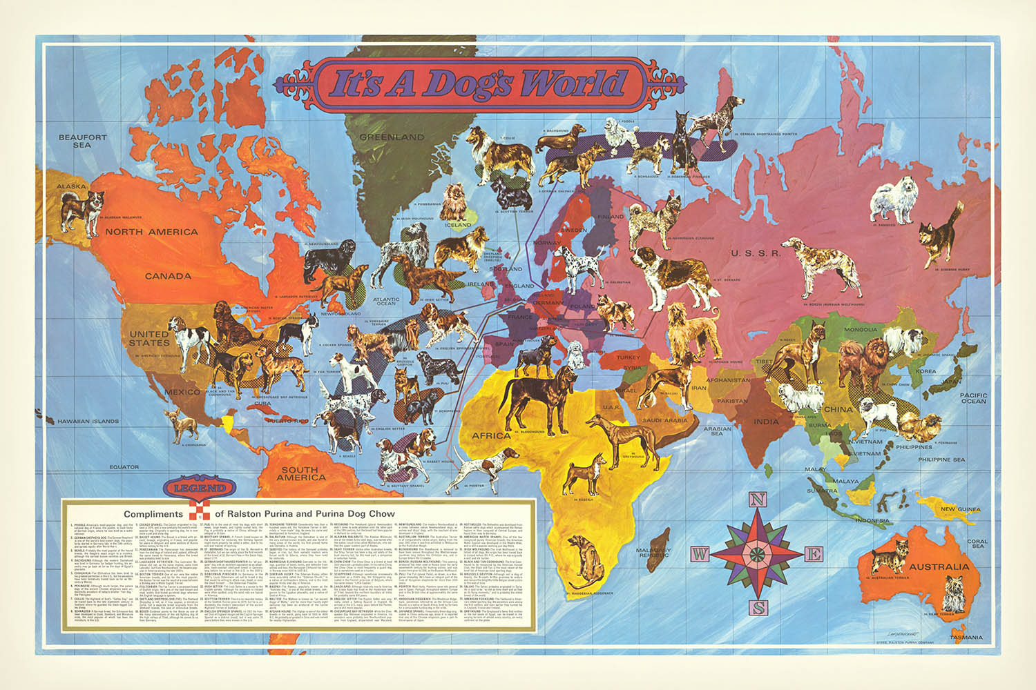
"Es un mundo de perros" es un cautivador mapa temático creado en 1968 por Langeneckert para la Ralston Purina Company. Este mapa único superpone la distribución global de razas caninas sobre las fronteras geopolíticas de mediados del siglo XX, ofreciendo una perspectiva lúdica pero educativa sobre el mundo de los perros. Como un artículo promocional para Purina Dog Chow, refleja las intersecciones culturales de la época entre las industrias de cuidado de mascotas y la cultura del consumidor, capturando el creciente interés en las mascotas domésticas y su papel como compañeros y símbolos familiares.
El diseño del mapa es un vibrante tapiz de color y detalle, ilustrando los orígenes geográficos y las razas populares en cada región. Desde los perros de trineo de Alaska y el norte de Canadá hasta los elegantes sabuesos de Europa y las robustas razas de la Unión Soviética, cada raza está meticulosamente colocada para alinearse con su región de origen. La vívida paleta de colores no solo mejora el atractivo visual, sino que también sirve para educar a los espectadores sobre la rica diversidad de razas caninas en diferentes continentes.
La destreza artística de Langeneckert es evidente en el cuidadoso equilibrio del contenido educativo y el mensaje promocional del mapa. La leyenda y el texto promocional están colocados de manera discreta en la esquina inferior izquierda, asegurando que el propósito educativo del mapa esté perfectamente integrado con su función como herramienta publicitaria. Esta elección de diseño reflexiva refleja la creciente cultura del consumidor de mediados del siglo XX, donde empresas como Ralston Purina buscaban crear conexiones directas entre sus productos y la vida diaria de sus clientes.
La importancia histórica del mapa radica en su reflejo de las dinámicas culturales y comerciales de la época. Como un mapa temático y pictórico, no solo promueve el alcance global de los productos de Ralston Purina, sino que también educa a los espectadores sobre la distribución global de las razas de perros. Este doble propósito destaca la interacción entre la cultura del consumidor y el creciente interés en las mascotas durante mediados del siglo XX, convirtiéndolo en un fascinante artefacto de su tiempo.
Incorporando elementos como una rosa de los vientos y cuerpos de agua detallados, el mapa es tanto una obra de arte como un logro cartográfico. La inclusión de características como el mar de Beaufort, el océano Atlántico y el océano Pacífico añade profundidad y contexto, mejorando el valor educativo del mapa. "Es un mundo de perros" es un testimonio de la creatividad e innovación de sus creadores, ofreciendo una visión única del mundo de los perros y el paisaje cultural de la década de 1960.
Razas de perros mostradas en este mapa
- Alaskan Malamute
- American Foxhound
- American Water Spaniel
- Black and Tan Coonhound
- Chesapeake Bay Retriever
- Chihuahua
- Boston Terrier
- Labrador Retriever
- Cocker Spaniel
- Fox Terrier
- English Setter
- Beagle
- Yorkshire Terrier
- English Springer Spaniel
- Irish Setter
- Irish Wolfhound
- Pomeranian
- Puli
- Schippeike
- Basset Hound
- Brittany Spaniel
- Pointer
- Bloodhound
- Rottweiler
- Shetland Sheepdog (Sheltie)
- Collie
- Scottish Terrier
- Dachshund
- German Shepherd
- Poodle
- Schnauzer
- Doberman Pinscher
- German Shorthaired Pointer
- Dalmatian
- Keeshound
- Greyhound
- Basenji
- Rhodesian Ridgeback
- Saluki
- Afghan Hound
- St. Bernard
- Norwegian Elkhound
- Borzoi (Perro Lobo Ruso)
- Boxer
- Lhasa Apso
- Samoyedo
- Husky Siberiano
- Spaniel Japonés
- Chow Chow
- Pug
- Pekines
- Terrier Australiano
- Terrier Sedoso
Países y regiones en este mapa
- América del Norte
- Canadá
- Estados Unidos
- México
- América del Sur
- Groenlandia
- Islandia
- Europa
- U.R.S.S.
- Mongolia
- China
- India
- Arabia Saudita
- Península Arábiga
- África
- Australia
- Nueva Guinea
- Japón
- Filipinas
- Indonesia
- Malasia
- Vietnam
- Corea
Características y Monumentos Notables
- Cuerpos de Agua:
- Mar de Beaufort
- Océano Atlántico
- Océano Pacífico
- Mar Arábigo
- Mar de Filipinas
- Mar de Coral
- Rosa de los Vientos: Ubicada en la esquina inferior derecha, indicando las direcciones cardinales.
- Leyenda: Posicionada en la esquina inferior izquierda, proporcionando contexto e información sobre las razas y el mapa.
- Texto Promocional: Acompaña la leyenda, promoviendo Ralston Purina y Purina Dog Chow.
Contexto Histórico y de Diseño
- Fecha de Creación: 1968
- Cartógrafo/Editor: Langeneckert / Ralston Purina Company
- Temas y Temáticas:
- Mapa temático y pictórico que representa razas caninas superpuestas a las fronteras geopolíticas de mediados del siglo XX.
- Destaca el creciente interés en las mascotas y la cultura del consumo durante mediados del siglo XX.
- Educa sobre la distribución global de razas de perros mientras promueve los productos de la empresa.
- Diseño y Estilo:
- Paleta de colores vívidos utilizada para ilustrar los orígenes geográficos y las razas populares en cada región.
- La leyenda y el texto promocional se colocan de manera discreta para equilibrar los propósitos educativos con la publicidad.
- Significado Histórico:
- Refleja el creciente interés en las mascotas y el auge de la cultura del consumo en la mitad del siglo XX.
- Demuestra el alcance global de los productos de Ralston Purina y la diversidad de razas caninas.
Por favor, verifica las imágenes para asegurarte de que una ciudad o lugar específico esté mostrado en este mapa. También puedes ponerte en contacto y pedirnos que revisemos el mapa por ti.
Este mapa se ve genial en cualquier tamaño, pero siempre recomiendo optar por un tamaño más grande si tienes espacio. De esa manera, puedes distinguir fácilmente todos los detalles.
Este mapa se ve increíble en tamaños de hasta 100in (250cm). Si estás buscando un mapa más grande, por favor ponte en contacto.
El modelo en las imágenes de la lista sostiene la versión de este mapa de 24x36in (60x90cm).
La quinta imagen de la lista muestra un ejemplo de mi servicio de personalización de mapas.
Si estás buscando algo ligeramente diferente, echa un vistazo a mi colección de los mejores mapas antiguos para ver si algo más llama tu atención.
Por favor contáctame para verificar si una ubicación, monumento o característica específica está mostrada en este mapa.
Esto sería un maravilloso regalo de cumpleaños, Navidad, Día del Padre, despedida laboral, aniversario o inauguración de casa para alguien de las áreas cubiertas por este mapa.
Este mapa está disponible como una impresión giclée en papel mate archivístico libre de ácido, o puedes comprarlo enmarcado. El marco es un bonito y simple marco negro que se adapta a la mayoría de las estéticas. Por favor, ponte en contacto si deseas un color o material de marco diferente. Mis marcos están envidriados con acrílico de grado museo superclaro (perspex/acrylite), que es significativamente menos reflectante que el vidrio, más seguro, y siempre llegará en perfectas condiciones.
This map is also available as a float framed canvas, sometimes known as a shadow gap framed canvas or canvas floater. The map is printed on artist's cotton canvas and then stretched over a handmade box frame. We then "float" the canvas inside a wooden frame, which is available in a range of colours (black, dark brown, oak, antique gold and white). This is a wonderful way to present a map without glazing in front. See some examples of float framed canvas maps and explore the differences between my different finishes.
For something truly unique, this map is also available in "Unique 3D", our trademarked process that dramatically transforms the map so that it has a wonderful sense of depth. We combine the original map with detailed topography and elevation data, so that mountains and the terrain really "pop". For more info and examples of 3D maps, check my Unique 3D page.
Many of our maps and art prints are chosen as thoughtful gifts for homes, offices, studies and meaningful places.
Choose a framed option for the easiest ready-to-hang gift, or choose an unframed print if the recipient may prefer to select their own frame.
We make orders locally in 23 countries around the world, so gifts can often be produced close to the recipient. This helps them arrive faster, travel more safely, and avoid customs or import duty surprises.
- We can deliver directly to the recipient
- Framed pieces arrive ready to hang
- Unframed prints are carefully packed in a strong protective tube
- Almost every order is made locally, for faster, safer gifting
- 90-day returns give the recipient time to decide
If you are not sure what to choose, please contact us. We can help you pick the right map, size, finish or delivery option.
Para la mayoría de los pedidos, el tiempo de entrega es de aproximadamente 3 días laborables. Los productos personalizados y a medida tardan más, ya que tengo que hacer la personalización y enviártelo para su aprobación, lo cual suele tardar 1 o 2 días.
Tenga en cuenta que los pedidos enmarcados muy grandes suelen tardar más en fabricarse y entregarse.
Si necesitas que tu pedido llegue para una fecha determinada, por favor contáctame antes de hacer el pedido para que podamos encontrar la mejor manera de asegurarnos de que recibas tu pedido a tiempo.
Imprimo y enmarco mapas y obras de arte en 23 países alrededor del mundo. Esto significa que tu pedido se fabricará localmente, lo que reduce el tiempo de entrega y asegura que no se dañe durante el envío. Nunca pagarás aranceles de aduana o impuestos de importación, y pondremos menos CO2 en el aire.
Todos mis mapas y impresiones artísticas están bien empaquetados y enviados en un tubo resistente si no están enmarcados, o rodeados de espuma si están enmarcados.
Intento enviar todos los pedidos dentro de 1 o 2 días después de recibir tu pedido, aunque algunos productos (como mascarillas, tazas y bolsas de tela) pueden tardar más en fabricarse.
Si seleccionas Entrega Exprés al finalizar la compra, priorizaremos tu pedido y lo enviaremos por mensajería de 1 día (Fedex, DHL, UPS, Parcelforce).
La entrega al día siguiente también está disponible en algunos países (EE. UU., Reino Unido, Singapur, EAU), pero por favor intenta hacer tu pedido temprano en el día para que podamos enviarlo a tiempo.
Mi marco estándar es un marco de madera de fresno negro estilo galería. Es simple y tiene un aspecto bastante moderno. Mi marco estándar tiene alrededor de 20 mm (0.8 in) de ancho.
Utilizo acrílico super claro (perspex/acrylite) para el vidrio del marco. Es más ligero y seguro que el vidrio, y se ve mejor, ya que la reflectividad es menor.
Seis colores de marco estándar están disponibles de forma gratuita (negro, marrón oscuro, gris oscuro, roble, blanco y oro antiguo).El enmarcado y montaje/matizado personalizado está disponible si buscas algo diferente.
La mayoría de los mapas, arte e ilustraciones también están disponibles como un lienzo enmarcado. Utilizamos lienzo de algodón mate (no brillante), lo estiramos sobre un marco de madera de caja de origen sostenible, y luego 'flotamos' la pieza dentro de un marco de madera. El resultado final es bastante hermoso, y no hay cristal que se interponga.
Todos los marcos se proporcionan "listos para colgar", con una cuerda o soportes en la parte posterior. Los marcos muy grandes tendrán placas de colgar de alta resistencia y/o un listón de montaje. Si tienes alguna pregunta, por favor ponte en contacto.
Mira algunos ejemplos de mis mapas enmarcados y mapas en lienzo enmarcados.
Alternativamente, también puedo proporcionar mapas antiguos y obras de arte en lienzo, tablero de espuma, papel de algodón y otros materiales.
Si deseas enmarcar tu mapa o obra de arte tú mismo, por favor lee mi guía de tamaños primero.
Mis mapas son reproducciones de mapas originales de altísima calidad.
Obtengo mapas originales y raros de bibliotecas, casas de subastas y colecciones privadas de todo el mundo, los restauro en mi taller de Londres y luego uso tintas e impresoras giclée especializadas para crear hermosos mapas que lucen incluso mejor que el original.
Mis mapas están impresos en papel de archivo mate (no brillante) sin ácido que se siente de muy alta calidad y casi como una tarjeta. En términos técnicos, el peso/grosor del papel es de 10 mil/200 g/m². Es perfecto para enmarcar.
Imprimo con tintas pigmentadas Epson ultrachrome giclée UV resistentes a la decoloración, algunas de las mejores tintas que puedes encontrar.
yo también puedo hacer mapas sobre lienzo, trapo de algodón y otros materiales exóticos.
Obtenga más información sobre The Unique Maps Co..
Personalización de mapas
Si está buscando el regalo perfecto de aniversario o inauguración de la casa, puedo personalizar su mapa para hacerlo verdaderamente único. Por ejemplo, puedo agregar un mensaje corto, resaltar una ubicación importante o agregar el escudo de armas de su familia.
Las opciones son casi infinitas. Por favor mira mi página de personalización de mapas para ver algunos maravillosos ejemplos de lo que es posible.
Para pedir un mapa personalizado, seleccione "personalizar su mapa" antes de agregarlo a su carrito.
Ponerse en contacto si buscas personalizaciones y personalizaciones más complejas.
Envejecimiento del mapa
A lo largo de los años, los clientes me han preguntado cientos de veces si podían comprar un mapa que se viera uniforme. más viejo.
Bueno, ahora puedes hacerlo seleccionando Envejecido antes de agregar un mapa a tu carrito.
Todas las fotografías de productos que ve en esta página muestran el mapa en su forma original. Así es como se ve el mapa hoy.
Si selecciona Envejecido, envejeceré su mapa a mano, usando un proceso especial y único desarrollado a través de años de estudiar mapas antiguos, hablar con investigadores para comprender la química del envejecimiento del papel y, por supuesto... ¡mucha práctica!
Si no estás seguro, quédate con el color original del mapa. Si quieres algo un poco más oscuro y más viejo buscando, opte por Envejecido.
Si no estás satisfecho con tu pedido por cualquier motivo, contáctame para un reembolso sin complicaciones. Por favor, consulta nuestra política de devoluciones y reembolsos para más información.
Estoy muy seguro de que te gustará tu mapa o impresión artística restaurada. He estado haciendo esto desde 1984. Soy un vendedor de 5 estrellas en Etsy. He vendido decenas de miles de mapas e impresiones artísticas y tengo más de 5,000 opiniones reales de 5 estrellas.
Utilizo un proceso único para restaurar mapas y obras de arte que consume mucho tiempo y mano de obra. Buscar los mapas e ilustraciones originales puede llevar meses. Utilizo tecnología de última generación y extremadamente cara para escanear y restaurarlos. Como resultado, garantizo que mis mapas e impresiones artísticas son superiores a los demás - por eso puedo ofrecer un reembolso sin complicaciones.
Casi todos mis mapas e impresiones artísticas se ven increíbles en tamaños grandes (200cm, 6.5ft+) y también puedo enmarcarlos y entregártelos a través de un servicio de mensajería especial para tamaños grandes. Contáctame para discutir tus necesidades específicas.
Or try searching for something!


