


Mapa pictórico antiguo de Kauai, 1935: Cañón de Waimea, Costa de Na Pali, Bahía de Hanalei, Monte Waialeale, Río Wailua
20% de descuento en 2 — 33% de descuento en 3
Añade dos artículos elegibles a tu carrito para recibir 20% de descuento. Añade un tercero y será complementario (equivalente a 33% de descuento al comprar tres).
No se necesita código — la oferta se aplica automáticamente al finalizar la compra.
Válido en todos los mapas estándar y impresiones de arte fino. Puedes mezclar y combinar cualquier diseño.
Si deseas enviar artículos a múltiples direcciones, por favor contáctanos antes de realizar tu pedido.
Las comisiones personalizadas y a medida están excluidas.
Contáctanos si tienes alguna pregunta
 Diseñado en Londres Hecho en the USA
Diseñado en Londres • Hecho en the USA
Diseñado en Londres Hecho en the USA
Diseñado en Londres • Hecho en the USA

Choose your size
Choose your finish


(Más información)
Mensaje de regalo y acabado personalizado

Si deseas agregar un mensaje de regalo, o un acabado (rompecabezas, tablero de aluminio, etc.) que no esté disponible aquí, por favor solicítalo en la "nota del pedido" cuando realices la compra.
Cada pedido es hecho a medida, así que si necesitas que el tamaño se ajuste ligeramente, o que se imprima en un material inusual, háznoslo saber. Hemos realizado miles de pedidos personalizados a lo largo de los años, así que hay (casi) nada que no podamos gestionar.
También puedes contactarnos antes de hacer tu pedido, ¡si lo prefieres!

- Made locally for fast, safe delivery
- No import duty or hidden fees
- Need advice? Message us on WhatsApp
Own a piece of history
7,000+ 5 star reviews


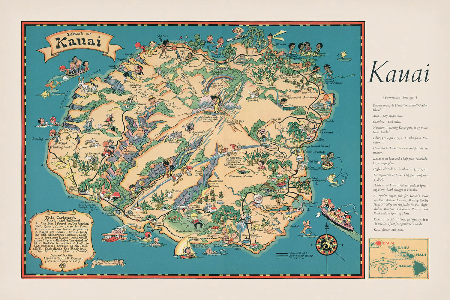
Adéntrese en el exuberante y legendario mundo de la Isla Jardín de Hawái con el mapa pictórico de 1935 titulado simplemente “Kauai”, una cautivadora creación de la renombrada Hawaii Tourist Bureau. Este mapa es más que una herramienta de navegación: es una vibrante ventana al pasado, que refleja tanto la grandeza natural de la isla como el espíritu de exploración y ocio de comienzos del siglo XX. Encargado durante una época crucial en la que Hawái emergía como un destino de viaje de primer orden, el título original del mapa señala su propósito: atraer y orientar a los visitantes con las maravillas de Kauai, al tiempo que celebra su identidad única entre las islas hawaianas.
La Hawaii Tourist Bureau, la estimada editora detrás de esta obra, desempeñó un papel crucial en la configuración de la percepción de las islas durante la década de 1930. Sus mapas se elaboraban no solo para guiar, sino también para inspirar, combinando precisión y arte para mostrar el atractivo de Hawái. Este mapa en particular es un testimonio de su misión, al combinar con maestría la precisión cartográfica con detalles pictóricos. Cada detalle ilustrado—ya fuera un río sinuoso o una costa dramática—se eligió para evocar el romanticismo y la aventura de un viaje a Kauai, invitando a los observadores a imaginarse entre sus paisajes sobrecogedores.
El diseño de este mapa es una lección magistral de la cartografía pictórica de comienzos del siglo XX. A diferencia de los mapas convencionales, rebosa de ilustraciones artísticas: las palmeras se mecen a lo largo de las costas, mientras que el terreno ondulado se representa en verdes intensos y tonos terrosos. El estilo pictórico atrae la mirada tanto hacia lo grandioso como hacia lo íntimo, con rasgos destacados como Waimea Canyon, la Costa Na Pali y Mount Waialeale, representados en un relieve dramático. Estos hitos no son solo referencias geográficas, sino también iconos culturales, cada uno impregnado de historias que han moldeado la identidad de la isla a lo largo de los siglos.
Las maravillas naturales de Kauai ocupan un lugar de honor, desde la serena extensión de Hanalei Bay hasta la belleza salvaje y remota de Kalalau Valley. El mapa también destaca el río Wailua, una arteria vital que atraviesa el corazón de la isla, y el santuario de altura de Kokee State Park. Las actividades recreativas—surf, pesca, navegación—se ilustran con encanto, capturando la vibrante vida al aire libre que durante mucho tiempo ha atraído a visitantes a las costas de Kauai. La inclusión de flora local y motivos tradicionales hawaianos enriquece aún más la narrativa visual, ofreciendo una visión del tapiz ecológico y cultural de la isla.
Entrelazados con estos prodigios naturales aparecen los pueblos y asentamientos históricos de la isla, entre ellos Lihue, Kapaa, Waimea, Hanalei, Koloa y Kekaha. Cada uno está cuidadosamente situado, aportando una sensación tanto de geografía como de comunidad. El cuidadoso equilibrio entre arte e información hace de este mapa un artefacto notable para coleccionistas e historiadores por igual, que encapsula un momento en que la belleza de Kauai se compartía con el mundo de formas nuevas y encantadoras. Este mapa no es meramente un registro del lugar: es una invitación a experimentar la magia perdurable de Kauai.
Ciudades y pueblos en este mapa
- Lihue
- Kapaa
- Waimea
- Hanalei
- Koloa
- Kekaha
Características destacadas y puntos de interés
- Waimea Canyon, destacado y representado de forma prominente como un importante accidente natural.
- Na Pali Coast, claramente representada y etiquetada, conocida por sus espectaculares acantilados.
- Mount Waialeale, identificado como una montaña notable y reconocido como uno de los lugares más lluviosos de la Tierra.
- Río Wailua, ilustrado y rotulado, conocido por su importancia histórica y cultural.
- Bahía de Hanalei, claramente rotulada y representada como un elemento costero escénico.
- Valle de Kalalau, rotulado e ilustrado como un notable valle panorámico.
- Área del Parque Estatal de Kokee, representada y rotulada, conocida por su belleza natural y sus rutas de senderismo.
- Varias ilustraciones de la flora local, como palmeras y vegetación tropical, que realzan el frondoso entorno de la isla.
- Ilustraciones de actividades recreativas como el surf, la pesca y la navegación, destacando las oportunidades de turismo y ocio.
- Ilustraciones culturales, incluidas actividades y artefactos tradicionales hawaianos, que ponen de relieve el patrimonio cultural y las tradiciones locales.
Contexto histórico y de diseño
- Creado en 1935 (estimado), durante un periodo de promoción temprana del turismo en Hawái.
- Publicado por la Hawaii Tourist Bureau, una organización conocida por promover las atracciones naturales y culturales de Hawái.
- Estilo de mapa pictórico y temático, que combina precisión cartográfica con ilustración artística.
- Diseñado para resaltar visualmente la importancia geográfica, cultural e histórica de Kauai.
- Refleja las prácticas cartográficas de principios del siglo XX y el creciente interés por Hawái como destino de viaje.
- Ofrece una valiosa perspectiva sobre cómo se representaba Kauai a los visitantes en la década de 1930, tanto como un paraíso natural como un tesoro cultural.
Por favor, revise bien las imágenes para asegurarse de que en este mapa aparezca una ciudad o lugar concreto. También puede ponerse en contacto con nosotros y pedirnos que revisemos el mapa por usted.
Este mapa luce estupendo en cualquier tamaño, pero siempre recomiendo optar por un tamaño mayor si dispone de espacio. De ese modo podrá apreciar fácilmente todos los detalles.
Este mapa luce increíble en tamaños de hasta 70in (180cm). Si busca un mapa más grande, por favor póngase en contacto.
La modelo de las imágenes del anuncio sostiene la versión de 24x36in (60x90cm) de este mapa.
La quinta imagen del anuncio muestra un ejemplo de mi servicio de personalización de mapas.
Si busca algo ligeramente diferente, eche un vistazo a mi colección de los mejores mapas antiguos para ver si algo más le llama la atención.
Por favor, contácteme para comprobar si una determinada ubicación, hito o elemento aparece en este mapa.
Sería un regalo maravilloso de cumpleaños, Navidad, Día del Padre, despedida del trabajo, aniversario o inauguración de casa para alguien de las zonas cubiertas por este mapa.
Este mapa está disponible como impresión giclée en papel mate de archivo libre de ácido, o puede adquirirlo enmarcado. El marco es un bonito y sencillo marco negro que combina con la mayoría de las estéticas. Por favor, póngase en contacto si desea un color o material de marco diferente. Nuestros marcos están acristalados con acrílico de calidad museo supertransparente (perspex/acrylite), que es significativamente menos reflectante que el vidrio, más seguro y siempre llegará en perfectas condiciones.
This map is also available as a float framed canvas, sometimes known as a shadow gap framed canvas or canvas floater. The map is printed on artist's cotton canvas and then stretched over a handmade box frame. We then "float" the canvas inside a wooden frame, which is available in a range of colours (black, dark brown, oak, antique gold and white). This is a wonderful way to present a map without glazing in front. See some examples of float framed canvas maps and explore the differences between my different finishes.
For something truly unique, this map is also available in "Unique 3D", our trademarked process that dramatically transforms the map so that it has a wonderful sense of depth. We combine the original map with detailed topography and elevation data, so that mountains and the terrain really "pop". For more info and examples of 3D maps, check my Unique 3D page.
Many of our maps and art prints are chosen as thoughtful gifts for homes, offices, studies and meaningful places.
Choose a framed option for the easiest ready-to-hang gift, or choose an unframed print if the recipient may prefer to select their own frame.
We make orders locally in 23 countries around the world, so gifts can often be produced close to the recipient. This helps them arrive faster, travel more safely, and avoid customs or import duty surprises.
- We can deliver directly to the recipient
- Framed pieces arrive ready to hang
- Unframed prints are carefully packed in a strong protective tube
- Almost every order is made locally, for faster, safer gifting
- 90-day returns give the recipient time to decide
If you are not sure what to choose, please contact us. We can help you pick the right map, size, finish or delivery option.
Para la mayoría de los pedidos, el tiempo de entrega es de aproximadamente 3 días laborables. Los productos personalizados y a medida tardan más, ya que tengo que hacer la personalización y enviártelo para su aprobación, lo cual suele tardar 1 o 2 días.
Tenga en cuenta que los pedidos enmarcados muy grandes suelen tardar más en fabricarse y entregarse.
Si necesitas que tu pedido llegue para una fecha determinada, por favor contáctame antes de hacer el pedido para que podamos encontrar la mejor manera de asegurarnos de que recibas tu pedido a tiempo.
Imprimo y enmarco mapas y obras de arte en 23 países alrededor del mundo. Esto significa que tu pedido se fabricará localmente, lo que reduce el tiempo de entrega y asegura que no se dañe durante el envío. Nunca pagarás aranceles de aduana o impuestos de importación, y pondremos menos CO2 en el aire.
Todos mis mapas y impresiones artísticas están bien empaquetados y enviados en un tubo resistente si no están enmarcados, o rodeados de espuma si están enmarcados.
Intento enviar todos los pedidos dentro de 1 o 2 días después de recibir tu pedido, aunque algunos productos (como mascarillas, tazas y bolsas de tela) pueden tardar más en fabricarse.
Si seleccionas Entrega Exprés al finalizar la compra, priorizaremos tu pedido y lo enviaremos por mensajería de 1 día (Fedex, DHL, UPS, Parcelforce).
La entrega al día siguiente también está disponible en algunos países (EE. UU., Reino Unido, Singapur, EAU), pero por favor intenta hacer tu pedido temprano en el día para que podamos enviarlo a tiempo.
Mi marco estándar es un marco de madera de fresno negro estilo galería. Es simple y tiene un aspecto bastante moderno. Mi marco estándar tiene alrededor de 20 mm (0.8 in) de ancho.
Utilizo acrílico super claro (perspex/acrylite) para el vidrio del marco. Es más ligero y seguro que el vidrio, y se ve mejor, ya que la reflectividad es menor.
Seis colores de marco estándar están disponibles de forma gratuita (negro, marrón oscuro, gris oscuro, roble, blanco y oro antiguo).El enmarcado y montaje/matizado personalizado está disponible si buscas algo diferente.
La mayoría de los mapas, arte e ilustraciones también están disponibles como un lienzo enmarcado. Utilizamos lienzo de algodón mate (no brillante), lo estiramos sobre un marco de madera de caja de origen sostenible, y luego 'flotamos' la pieza dentro de un marco de madera. El resultado final es bastante hermoso, y no hay cristal que se interponga.
Todos los marcos se proporcionan "listos para colgar", con una cuerda o soportes en la parte posterior. Los marcos muy grandes tendrán placas de colgar de alta resistencia y/o un listón de montaje. Si tienes alguna pregunta, por favor ponte en contacto.
Mira algunos ejemplos de mis mapas enmarcados y mapas en lienzo enmarcados.
Alternativamente, también puedo proporcionar mapas antiguos y obras de arte en lienzo, tablero de espuma, papel de algodón y otros materiales.
Si deseas enmarcar tu mapa o obra de arte tú mismo, por favor lee mi guía de tamaños primero.
Mis mapas son reproducciones de mapas originales de altísima calidad.
Obtengo mapas originales y raros de bibliotecas, casas de subastas y colecciones privadas de todo el mundo, los restauro en mi taller de Londres y luego uso tintas e impresoras giclée especializadas para crear hermosos mapas que lucen incluso mejor que el original.
Mis mapas están impresos en papel de archivo mate (no brillante) sin ácido que se siente de muy alta calidad y casi como una tarjeta. En términos técnicos, el peso/grosor del papel es de 10 mil/200 g/m². Es perfecto para enmarcar.
Imprimo con tintas pigmentadas Epson ultrachrome giclée UV resistentes a la decoloración, algunas de las mejores tintas que puedes encontrar.
yo también puedo hacer mapas sobre lienzo, trapo de algodón y otros materiales exóticos.
Obtenga más información sobre The Unique Maps Co..
Personalización de mapas
Si está buscando el regalo perfecto de aniversario o inauguración de la casa, puedo personalizar su mapa para hacerlo verdaderamente único. Por ejemplo, puedo agregar un mensaje corto, resaltar una ubicación importante o agregar el escudo de armas de su familia.
Las opciones son casi infinitas. Por favor mira mi página de personalización de mapas para ver algunos maravillosos ejemplos de lo que es posible.
Para pedir un mapa personalizado, seleccione "personalizar su mapa" antes de agregarlo a su carrito.
Ponerse en contacto si buscas personalizaciones y personalizaciones más complejas.
Envejecimiento del mapa
A lo largo de los años, los clientes me han preguntado cientos de veces si podían comprar un mapa que se viera uniforme. más viejo.
Bueno, ahora puedes hacerlo seleccionando Envejecido antes de agregar un mapa a tu carrito.
Todas las fotografías de productos que ve en esta página muestran el mapa en su forma original. Así es como se ve el mapa hoy.
Si selecciona Envejecido, envejeceré su mapa a mano, usando un proceso especial y único desarrollado a través de años de estudiar mapas antiguos, hablar con investigadores para comprender la química del envejecimiento del papel y, por supuesto... ¡mucha práctica!
Si no estás seguro, quédate con el color original del mapa. Si quieres algo un poco más oscuro y más viejo buscando, opte por Envejecido.
Si no estás satisfecho con tu pedido por cualquier motivo, contáctame para un reembolso sin complicaciones. Por favor, consulta nuestra política de devoluciones y reembolsos para más información.
Estoy muy seguro de que te gustará tu mapa o impresión artística restaurada. He estado haciendo esto desde 1984. Soy un vendedor de 5 estrellas en Etsy. He vendido decenas de miles de mapas e impresiones artísticas y tengo más de 5,000 opiniones reales de 5 estrellas.
Utilizo un proceso único para restaurar mapas y obras de arte que consume mucho tiempo y mano de obra. Buscar los mapas e ilustraciones originales puede llevar meses. Utilizo tecnología de última generación y extremadamente cara para escanear y restaurarlos. Como resultado, garantizo que mis mapas e impresiones artísticas son superiores a los demás - por eso puedo ofrecer un reembolso sin complicaciones.
Casi todos mis mapas e impresiones artísticas se ven increíbles en tamaños grandes (200cm, 6.5ft+) y también puedo enmarcarlos y entregártelos a través de un servicio de mensajería especial para tamaños grandes. Contáctame para discutir tus necesidades específicas.
Or try searching for something!


