


Mapa pictórico de Arizona de Ruth Taylor White, 1935: Gran Cañón, Phoenix, Tucson, Desierto Pintado, Bosque Petrificado
20% de descuento en 2 — 33% de descuento en 3
Añade dos artículos elegibles a tu carrito para recibir 20% de descuento. Añade un tercero y será complementario (equivalente a 33% de descuento al comprar tres).
No se necesita código — la oferta se aplica automáticamente al finalizar la compra.
Válido en todos los mapas estándar y impresiones de arte fino. Puedes mezclar y combinar cualquier diseño.
Si deseas enviar artículos a múltiples direcciones, por favor contáctanos antes de realizar tu pedido.
Las comisiones personalizadas y a medida están excluidas.
Contáctanos si tienes alguna pregunta
 Diseñado en Londres Hecho en the USA
Diseñado en Londres • Hecho en the USA
Diseñado en Londres Hecho en the USA
Diseñado en Londres • Hecho en the USA

Choose your size
Choose your finish


(Más información)
Mensaje de regalo y acabado personalizado

Si deseas agregar un mensaje de regalo, o un acabado (rompecabezas, tablero de aluminio, etc.) que no esté disponible aquí, por favor solicítalo en la "nota del pedido" cuando realices la compra.
Cada pedido es hecho a medida, así que si necesitas que el tamaño se ajuste ligeramente, o que se imprima en un material inusual, háznoslo saber. Hemos realizado miles de pedidos personalizados a lo largo de los años, así que hay (casi) nada que no podamos gestionar.
También puedes contactarnos antes de hacer tu pedido, ¡si lo prefieres!

- Made locally for fast, safe delivery
- No import duty or hidden fees
- Need advice? Message us on WhatsApp
Own a piece of history
7,000+ 5 star reviews


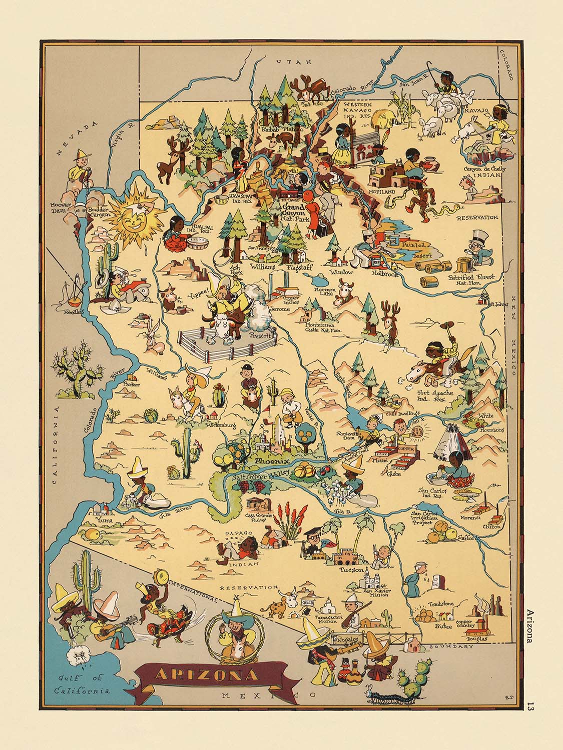
Adéntrese en el vibrante mundo de Arizona en la década de 1930 con este cautivador mapa pictórico, titulado originalmente "Arizona" y creado por la célebre cartógrafa Ruth Taylor White en 1935. Este mapa es una magistral combinación de arte e información, diseñada para deleitar la vista al tiempo que ofrece una vívida ventana al paisaje social y geográfico del Estado del Gran Cañón durante una época de transformación. Cada condado está cuidadosamente delimitado, y todo el estado cobra vida a través de un tapiz de ilustraciones caprichosas, invitando al espectador a explorar tanto el terreno físico como el espíritu cultural de Arizona tal como fue imaginado hace casi un siglo.
Ruth Taylor White, reconocida por su enfoque atractivo y accesible de la cartografía, impregnó sus mapas de un sentido único de personalidad y encanto. Su obra destaca por su estilo lúdico, de aire caricaturesco, que fue una seña de identidad del movimiento de atlas pictóricos de comienzos del siglo XX. El mapa de Arizona de White no es una excepción, rebosante de viñetas coloridas que encapsulan la esencia de la vida local, desde los ásperos mineros del norte hasta los soleados ganaderos y agricultores del sur. Su atención tanto a los detalles minuciosos como a los grandes temas culturales convierte este mapa en un notable artefacto de la narrativa visual estadounidense.
El diseño de este mapa es tan informativo como encantador. Los principales hitos naturales se representan con precisión y elegancia: el sobrecogedor Parque Nacional del Gran Cañón capta la atención en el norte, mientras que el Painted Desert y el Petrified Forest se muestran con tonos vibrantes e imágenes evocadoras. El poderoso río Colorado recorre el borde occidental de Arizona, mientras que el río Gila serpentea por los condados del sur, con sus cursos marcados por divertidas ilustraciones de fauna y exuberantes escenas ribereñas. Los San Francisco Peaks se alzan majestuosamente, en alusión a la diversa topografía del estado, mientras que las extensiones de desierto, salpicadas de icónicos cactus saguaro, evocan la belleza árida que define gran parte del paisaje de Arizona.
Los motivos culturales e históricos se entrelazan por todo el mapa, reflejando el rico mosaico de pueblos y tradiciones que han dado forma a la identidad de Arizona. Figuras y motivos nativos americanos se ilustran con esmero, rindiendo homenaje al patrimonio indígena del estado. Las escenas de minería y ganadería, industrias que desempeñaron un papel decisivo en el desarrollo de Arizona, se representan con una mezcla de nostalgia y orgullo. La abundancia agrícola se celebra mediante vívidas representaciones de huertos de cítricos y campos de algodón, mientras que la presencia de ciervos, aves y otra fauna subraya la vitalidad natural de la región.
Más allá de sus méritos artísticos, este mapa es un fascinante documento histórico que captura la imaginación y las aspiraciones del Arizona de los años 30. Los condados del estado están claramente señalados, y una constelación de pueblos y ciudades, muchos de los cuales se han convertido desde entonces en importantes centros urbanos, salpica el paisaje. Desde Phoenix y Tucson hasta las históricas poblaciones mineras de Jerome y Bisbee, cada asentamiento está representado con detalle y afecto. Tanto si es usted coleccionista, historiador o simplemente admirador de la buena cartografía, el mapa "Arizona" de Ruth Taylor White ofrece una rara y encantadora visión del corazón del suroeste estadounidense, convirtiéndose en una incorporación excepcional para cualquier colección.
Ciudades y pueblos en este mapa
- Phoenix
- Tucson
- Mesa
- Chandler
- Glendale
- Scottsdale
- Tempe
- Prescott
- Yuma
- Flagstaff
- Nogales
- Douglas
- Bisbee
- Kingman
- Winslow
- Holbrook
- Safford
- Globe
- Florence
- Casa Grande
- Clifton
- Jerome
- Tombstone
- Ajo
- Coolidge
- Superior
- Miami
- Wickenburg
- Parker
- Williams
Características destacadas y hitos
- El Parque Nacional del Gran Cañón está ilustrado y rotulado.
- El Desierto Pintado está representado y rotulado.
- El Bosque Petrificado está mostrado y rotulado.
- Los picos San Francisco están ilustrados.
- El río Colorado se representa de forma destacada a lo largo de la frontera occidental.
- El río Gila se muestra atravesando el sur de Arizona.
- Se ilustran varias figuras y motivos nativos americanos, en referencia al patrimonio cultural de la región.
- Se representan escenas y símbolos mineros, como mineros y equipo de minería.
- Se ilustran imágenes de ranchería y vaqueros, incluidos ganado y caballos.
- Los cactus saguaro y los paisajes desérticos ocupan un lugar destacado.
- Hay ilustraciones de actividades agrícolas, como el cultivo de cítricos y algodón.
- El mapa incluye ilustraciones caprichosas de fauna, como ciervos y aves.
- Los límites y nombres de los condados están claramente marcados en todo el estado.
Contexto histórico y de diseño
- Nombre del mapa: Arizona (título original tal como aparece en el mapa).
- Cartógrafa: Ruth Taylor White.
- Fecha de creación: 1935.
- Forma parte de un atlas pictórico o de caricaturas de Estados Unidos, conocido por su estilo caprichoso y entretenido.
- El mapa está ricamente adornado con ilustraciones coloridas, de estilo caricaturesco, ofreciendo una representación visual caprichosa y atractiva de Arizona.
- Temas representados: escenas y elementos estereotípicos de la vida en Arizona durante la década de 1930, incluidas actividades culturales, sociales y económicas.
- Cobertura geográfica: todo el estado de Arizona, con límites y nombres de condados claramente marcados.
- Destacados visuales: el mapa utiliza imágenes vibrantes para resaltar rasgos geográficos significativos, como montañas, desiertos y ríos.
- Contexto cultural y social: las ilustraciones reflejan la identidad y la historia singulares de Arizona, incluidas representaciones de la cultura nativa americana, la minería, la ranchería y la vida en el desierto.
- Importancia histórica: el mapa ofrece una instantánea de cómo se percibía y representaba Arizona en la cultura popular a mediados de la década de 1930.
- Interés para coleccionistas: el mapa se considera una pieza cautivadora para coleccionistas y aficionados a la historia debido a su estilo artístico y contexto histórico.
Por favor, revisa las imágenes para asegurarte de que una ciudad o lugar específico aparece en este mapa. También puedes ponerte en contacto con nosotros y pedirnos que comprobemos el mapa por ti.
Este mapa luce estupendo en cualquier tamaño, pero siempre recomiendo optar por un tamaño más grande si tienes espacio. Así podrás apreciar fácilmente todos los detalles.
Este mapa luce increíble en tamaños de hasta 50in (125cm). Si buscas un mapa más grande, por favor ponte en contacto.
El modelo en las imágenes del anuncio sostiene la versión de 18x24in (45x60cm) de este mapa.
La quinta imagen del anuncio muestra un ejemplo de mi servicio de personalización de mapas.
Si buscas algo ligeramente diferente, echa un vistazo a mi colección de los mejores mapas antiguos para ver si algo más llama tu atención.
Por favor, contáctame para comprobar si una determinada ubicación, punto de referencia o elemento aparece en este mapa.
Esto haría un maravilloso regalo de cumpleaños, Navidad, Día del Padre, despedida laboral, aniversario o inauguración de casa para alguien procedente de las zonas cubiertas por este mapa.
Este mapa está disponible como impresión giclée en papel mate de archivo libre de ácido, o puede adquirirlo enmarcado. El marco es un marco negro, sencillo y elegante, que se adapta a la mayoría de las estéticas. Póngase en contacto con nosotros si desea un color o material de marco diferente. Mis marcos están acristalados con acrílico de calidad museo, supertransparente (perspex/acrylite), que es significativamente menos reflectante que el vidrio, más seguro y llegará siempre en perfectas condiciones.
This map is also available as a float framed canvas, sometimes known as a shadow gap framed canvas or canvas floater. The map is printed on artist's cotton canvas and then stretched over a handmade box frame. We then "float" the canvas inside a wooden frame, which is available in a range of colours (black, dark brown, oak, antique gold and white). This is a wonderful way to present a map without glazing in front. See some examples of float framed canvas maps and explore the differences between my different finishes.
For something truly unique, this map is also available in "Unique 3D", our trademarked process that dramatically transforms the map so that it has a wonderful sense of depth. We combine the original map with detailed topography and elevation data, so that mountains and the terrain really "pop". For more info and examples of 3D maps, check my Unique 3D page.
Many of our maps and art prints are chosen as thoughtful gifts for homes, offices, studies and meaningful places.
Choose a framed option for the easiest ready-to-hang gift, or choose an unframed print if the recipient may prefer to select their own frame.
We make orders locally in 23 countries around the world, so gifts can often be produced close to the recipient. This helps them arrive faster, travel more safely, and avoid customs or import duty surprises.
- We can deliver directly to the recipient
- Framed pieces arrive ready to hang
- Unframed prints are carefully packed in a strong protective tube
- Almost every order is made locally, for faster, safer gifting
- 90-day returns give the recipient time to decide
If you are not sure what to choose, please contact us. We can help you pick the right map, size, finish or delivery option.
Para la mayoría de los pedidos, el tiempo de entrega es de aproximadamente 3 días laborables. Los productos personalizados y a medida tardan más, ya que tengo que hacer la personalización y enviártelo para su aprobación, lo cual suele tardar 1 o 2 días.
Tenga en cuenta que los pedidos enmarcados muy grandes suelen tardar más en fabricarse y entregarse.
Si necesitas que tu pedido llegue para una fecha determinada, por favor contáctame antes de hacer el pedido para que podamos encontrar la mejor manera de asegurarnos de que recibas tu pedido a tiempo.
Imprimo y enmarco mapas y obras de arte en 23 países alrededor del mundo. Esto significa que tu pedido se fabricará localmente, lo que reduce el tiempo de entrega y asegura que no se dañe durante el envío. Nunca pagarás aranceles de aduana o impuestos de importación, y pondremos menos CO2 en el aire.
Todos mis mapas y impresiones artísticas están bien empaquetados y enviados en un tubo resistente si no están enmarcados, o rodeados de espuma si están enmarcados.
Intento enviar todos los pedidos dentro de 1 o 2 días después de recibir tu pedido, aunque algunos productos (como mascarillas, tazas y bolsas de tela) pueden tardar más en fabricarse.
Si seleccionas Entrega Exprés al finalizar la compra, priorizaremos tu pedido y lo enviaremos por mensajería de 1 día (Fedex, DHL, UPS, Parcelforce).
La entrega al día siguiente también está disponible en algunos países (EE. UU., Reino Unido, Singapur, EAU), pero por favor intenta hacer tu pedido temprano en el día para que podamos enviarlo a tiempo.
Mi marco estándar es un marco de madera de fresno negro estilo galería. Es simple y tiene un aspecto bastante moderno. Mi marco estándar tiene alrededor de 20 mm (0.8 in) de ancho.
Utilizo acrílico super claro (perspex/acrylite) para el vidrio del marco. Es más ligero y seguro que el vidrio, y se ve mejor, ya que la reflectividad es menor.
Seis colores de marco estándar están disponibles de forma gratuita (negro, marrón oscuro, gris oscuro, roble, blanco y oro antiguo).El enmarcado y montaje/matizado personalizado está disponible si buscas algo diferente.
La mayoría de los mapas, arte e ilustraciones también están disponibles como un lienzo enmarcado. Utilizamos lienzo de algodón mate (no brillante), lo estiramos sobre un marco de madera de caja de origen sostenible, y luego 'flotamos' la pieza dentro de un marco de madera. El resultado final es bastante hermoso, y no hay cristal que se interponga.
Todos los marcos se proporcionan "listos para colgar", con una cuerda o soportes en la parte posterior. Los marcos muy grandes tendrán placas de colgar de alta resistencia y/o un listón de montaje. Si tienes alguna pregunta, por favor ponte en contacto.
Mira algunos ejemplos de mis mapas enmarcados y mapas en lienzo enmarcados.
Alternativamente, también puedo proporcionar mapas antiguos y obras de arte en lienzo, tablero de espuma, papel de algodón y otros materiales.
Si deseas enmarcar tu mapa o obra de arte tú mismo, por favor lee mi guía de tamaños primero.
Mis mapas son reproducciones de mapas originales de altísima calidad.
Obtengo mapas originales y raros de bibliotecas, casas de subastas y colecciones privadas de todo el mundo, los restauro en mi taller de Londres y luego uso tintas e impresoras giclée especializadas para crear hermosos mapas que lucen incluso mejor que el original.
Mis mapas están impresos en papel de archivo mate (no brillante) sin ácido que se siente de muy alta calidad y casi como una tarjeta. En términos técnicos, el peso/grosor del papel es de 10 mil/200 g/m². Es perfecto para enmarcar.
Imprimo con tintas pigmentadas Epson ultrachrome giclée UV resistentes a la decoloración, algunas de las mejores tintas que puedes encontrar.
yo también puedo hacer mapas sobre lienzo, trapo de algodón y otros materiales exóticos.
Obtenga más información sobre The Unique Maps Co..
Personalización de mapas
Si está buscando el regalo perfecto de aniversario o inauguración de la casa, puedo personalizar su mapa para hacerlo verdaderamente único. Por ejemplo, puedo agregar un mensaje corto, resaltar una ubicación importante o agregar el escudo de armas de su familia.
Las opciones son casi infinitas. Por favor mira mi página de personalización de mapas para ver algunos maravillosos ejemplos de lo que es posible.
Para pedir un mapa personalizado, seleccione "personalizar su mapa" antes de agregarlo a su carrito.
Ponerse en contacto si buscas personalizaciones y personalizaciones más complejas.
Envejecimiento del mapa
A lo largo de los años, los clientes me han preguntado cientos de veces si podían comprar un mapa que se viera uniforme. más viejo.
Bueno, ahora puedes hacerlo seleccionando Envejecido antes de agregar un mapa a tu carrito.
Todas las fotografías de productos que ve en esta página muestran el mapa en su forma original. Así es como se ve el mapa hoy.
Si selecciona Envejecido, envejeceré su mapa a mano, usando un proceso especial y único desarrollado a través de años de estudiar mapas antiguos, hablar con investigadores para comprender la química del envejecimiento del papel y, por supuesto... ¡mucha práctica!
Si no estás seguro, quédate con el color original del mapa. Si quieres algo un poco más oscuro y más viejo buscando, opte por Envejecido.
Si no estás satisfecho con tu pedido por cualquier motivo, contáctame para un reembolso sin complicaciones. Por favor, consulta nuestra política de devoluciones y reembolsos para más información.
Estoy muy seguro de que te gustará tu mapa o impresión artística restaurada. He estado haciendo esto desde 1984. Soy un vendedor de 5 estrellas en Etsy. He vendido decenas de miles de mapas e impresiones artísticas y tengo más de 5,000 opiniones reales de 5 estrellas.
Utilizo un proceso único para restaurar mapas y obras de arte que consume mucho tiempo y mano de obra. Buscar los mapas e ilustraciones originales puede llevar meses. Utilizo tecnología de última generación y extremadamente cara para escanear y restaurarlos. Como resultado, garantizo que mis mapas e impresiones artísticas son superiores a los demás - por eso puedo ofrecer un reembolso sin complicaciones.
Casi todos mis mapas e impresiones artísticas se ven increíbles en tamaños grandes (200cm, 6.5ft+) y también puedo enmarcarlos y entregártelos a través de un servicio de mensajería especial para tamaños grandes. Contáctame para discutir tus necesidades específicas.
Or try searching for something!


