


Gran mapa antiguo de Oxford por Hoggar, 1850: Colegios, St. Giles', High St, Magdalen St, río Támesis
La oferta del coleccionista
Elija dos obras elegibles y obtenga un 20 % de descuento en ambas. Elija tres y la de menor precio será gratuita, con un ahorro máximo del 33 %.
Combine y mezcle mapas estándar elegibles y reproducciones de bellas artes. No se requiere código; la oferta se aplica automáticamente al finalizar la compra.
Se incluyen las configuraciones estándar hechas por encargo. Quedan excluidos los tamaños a medida, los diseños personalizados y los trabajos por encargo.
¿Necesita entrega en diferentes direcciones? Contáctenos antes de realizar el pedido.La oferta del coleccionista
Elija dos obras elegibles y obtenga un 20 % de descuento en ambas. Elija tres y la de menor precio será gratuita, con un ahorro máximo del 33 %.
Combine y mezcle mapas estándar elegibles y reproducciones de bellas artes. No se requiere código; la oferta se aplica automáticamente al finalizar la compra.
Se incluyen las configuraciones estándar hechas por encargo. Quedan excluidos los tamaños a medida, los diseños personalizados y los trabajos por encargo.
¿Necesita entrega en diferentes direcciones? Contáctenos antes de realizar el pedido. Diseñado en Londres Hecho en the USA
Diseñado en Londres • Hecho en the USA
Diseñado en Londres Hecho en the USA
Diseñado en Londres • Hecho en the USA

Restaurado a partir del mapa original de 1850 e impreso en calidad museo. Leer la historia detrás de este mapa
Choose your size
Choose your finish


(Más información)
Mensaje de regalo y acabado personalizado

Si deseas agregar un mensaje de regalo, o un acabado (rompecabezas, tablero de aluminio, etc.) que no esté disponible aquí, por favor solicítalo en la "nota del pedido" cuando realices la compra.
Cada pedido es hecho a medida, así que si necesitas que el tamaño se ajuste ligeramente, o que se imprima en un material inusual, háznoslo saber. Hemos realizado miles de pedidos personalizados a lo largo de los años, así que hay (casi) nada que no podamos gestionar.
También puedes contactarnos antes de hacer tu pedido, ¡si lo prefieres!

- Hecho localmente. Entrega segura
- Sin aranceles ni cargos ocultos
- ¿Necesitas ayuda? Llámanos o mensaje por WhatsApp
Own a piece of history
8,000+ five-star reviews


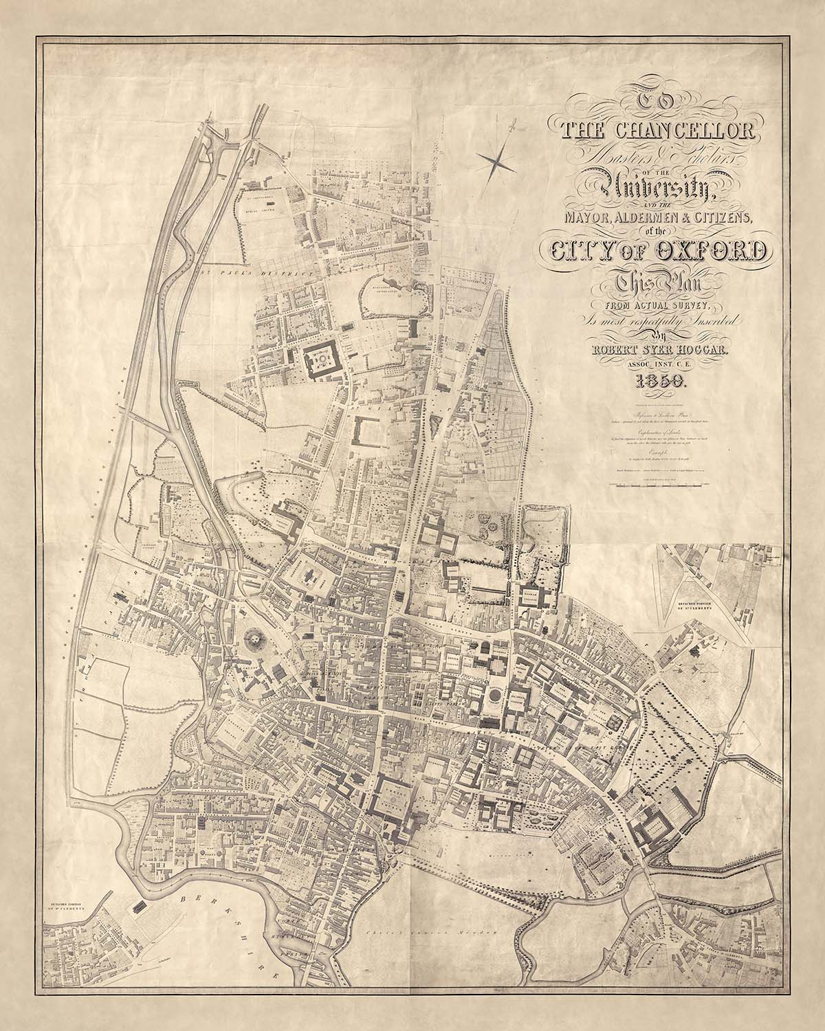
El "Plan de la Ciudad de Oxford" de Robert Syer Hoggar, elaborado en 1850, es una fascinante mirada al corazón histórico de...
Seguir leyendoEl "Plan de la Ciudad de Oxford" de Robert Syer Hoggar, elaborado en 1850, es una fascinante mirada al corazón histórico de una de las ciudades más renombradas de Inglaterra. Este mapa, producido para la investigación sanitaria de los Comisionados de Pavimentación de Oxford de 1851, no es solo una herramienta de navegación, sino un retrato detallado de la vida urbana a mediados del siglo XIX. Con su meticulosa representación de los principales edificios, colegios y límites de condados y parroquias claramente marcados, ofrece una ventana al paisaje arquitectónico y cívico de la época. La precisión y elegancia del mapa reflejan la experiencia de Hoggar como asociado de la Institución de Ingenieros Civiles.
El trabajo de Robert Syer Hoggar es un testimonio del arte y la ciencia de la cartografía en el siglo XIX. Su asociación con la Institución de Ingenieros Civiles subraya su compromiso con la precisión y el detalle, convirtiendo este mapa en un recurso invaluable para historiadores y entusiastas por igual. Grabado por Thos. Jones, el mapa es una obra maestra de diseño, que muestra los intrincados patrones de calles y los hitos significativos que definen a Oxford. La dedicación de Hoggar a su oficio es evidente en cada línea y contorno, capturando la esencia de una ciudad impregnada de historia y tradición.
Oxford, con su rica tapicería de vecindarios y monumentos, cobra vida a través del mapa de Hoggar. La representación de áreas como St. Giles' y Cornmarket Street revela el vibrante tejido urbano de la ciudad. Cada calle y edificio está cuidadosamente representado, ofreciendo perspectivas sobre la vida diaria y la estructura social de la época. La inclusión de vías significativas como High Street y Magdalen Street destaca las bulliciosas actividades comerciales y académicas que han sido durante mucho tiempo la marca distintiva de la ciudad.
El mapa también proporciona una mirada fascinante al entorno natural y construido de Oxford. La presencia del río Támesis, serpenteando a través de la ciudad, añade un elemento dinámico al paisaje urbano. La cuidadosa marcación de parques y espacios abiertos refleja el compromiso de la ciudad con las áreas verdes en medio de su esplendor arquitectónico. Este equilibrio entre la naturaleza y la urbanidad es una característica definitoria de Oxford, y el mapa de Hoggar lo captura con notable claridad y belleza.
En esencia, el "Plan de la Ciudad de Oxford" es más que un mapa; es un documento histórico que captura el espíritu de una ciudad en un momento crucial de su desarrollo. Su representación detallada de las calles, edificios y límites de Oxford ofrece una perspectiva única sobre la evolución de la ciudad y su legado perdurable. Para coleccionistas e historiadores, este mapa es un tesoro de información y un testimonio del arte y la precisión de la cartografía del siglo XIX.
Calles y caminos en este mapa
- Banbury Road
- Beaumont Street
- Broad Street
- Cornmarket Street
- George Street
- High Street
- Holywell Street
- Longwall Street
- Magdalen Street
- New Inn Hall Street
- New Road
- Parks Road
- Queen Street
- St. Aldate's
- St. Clement's Street
- St. Giles'
- St. John Street
- Turl Street
- Walton Street
- Wellington Square
- Worcester Street
Características y Monumentos Notables
- Mapas insets:
- Dos mapas insets de porciones separadas de la parroquia de St. Clement's.
- Monumentos:
- Numerosos edificios principales están nombrados.
- Vecindarios:
- Diseño detallado de las calles y vecindarios dentro de Oxford.
- Facultades:
- Todos los colegios de Oxford existentes en 1850 están claramente mostrados en este mapa
Contexto histórico y de diseño
- Fecha de creación: 1850
- Cartógrafo/Editor: Robert Syer Hoggar, grabado por Thos. Jones
- Propósito: Producido para la investigación sanitaria de los Comisionados de Pavimentación de Oxford de 1851.
- Temas y tópicos:
- Ilustra los edificios principales y marca los límites de condados y parroquias.
- Escala: 1 pulgada a 44 pies (1:1584).
- Regiones mostradas: La ciudad de Oxford, Inglaterra.
- Diseño/Estilo: Mapa de calles detallado con énfasis en edificios y límites, típico de la planificación urbana y mapas de encuesta de mediados del siglo XIX.
- Significado histórico: Refleja la planificación urbana y las preocupaciones sanitarias de la época, proporcionando información sobre Oxford a mediados del siglo XIX.
Por favor, verifica las imágenes para asegurarte de que una ciudad o lugar específico esté mostrado en este mapa. También puedes ponerte en contacto y pedirnos que verifiquemos el mapa por ti.
Este es un mapa muy grande que debe ser pedido en un tamaño grande, para que puedas distinguir fácilmente todos los detalles.
Este mapa se ve increíble en tamaños de hasta 100in (250cm). Si estás buscando un mapa más grande, por favor ponte en contacto.
El modelo en las imágenes del listado sostiene la versión de este mapa de 16x20in (40x50cm).
La quinta imagen del listado muestra un ejemplo de mi servicio de personalización de mapas.
Si buscas algo ligeramente diferente, echa un vistazo a mi colección de los mejores mapas antiguos para ver si algo más llama tu atención.
Por favor contáctame para verificar si una ubicación, hito o característica específica está mostrada en este mapa.
Este sería un maravilloso regalo de cumpleaños, Navidad, Día del Padre, despedida laboral, aniversario o de inauguración de casa para alguien de las áreas cubiertas por este mapa.
Este mapa está disponible como una impresión giclée en papel mate libre de ácido y de archivo, o puedes comprarlo enmarcado. El marco es un bonito y simple marco negro que se adapta a la mayoría de las estéticas. Por favor, ponte en contacto si deseas un color o material de marco diferente. Mis marcos están envidriados con acrílico de grado museo superclaro (perspex/acrylite), que es significativamente menos reflectante que el vidrio, más seguro, y siempre llegará en perfectas condiciones.
This map is also available as a float framed canvas, sometimes known as a shadow gap framed canvas or canvas floater. The map is printed on artist's cotton canvas and then stretched over a handmade box frame. We then "float" the canvas inside a wooden frame, which is available in a range of colours (black, dark brown, oak, antique gold and white). This is a wonderful way to present a map without glazing in front. See some examples of float framed canvas maps and explore the differences between my different finishes.
For something truly unique, this map is also available in "Unique 3D", our trademarked process that dramatically transforms the map so that it has a wonderful sense of depth. We combine the original map with detailed topography and elevation data, so that mountains and the terrain really "pop". For more info and examples of 3D maps, check my Unique 3D page.
El "Plan de la Ciudad de Oxford" de Robert Syer Hoggar, elaborado en 1850, es una fascinante mirada al corazón histórico de una de las ciudades más renombradas de Inglaterra. Este mapa, producido para la investigación sanitaria de los Comisionados de Pavimentación de Oxford de 1851, no es solo una herramienta de navegación, sino un retrato detallado de la vida urbana a mediados del siglo XIX. Con su meticulosa representación de los principales edificios, colegios y límites de condados y parroquias claramente marcados, ofrece una ventana al paisaje arquitectónico y cívico de la época. La precisión y elegancia del mapa reflejan la experiencia de Hoggar como asociado de la Institución de Ingenieros Civiles.
El trabajo de Robert Syer Hoggar es un testimonio del arte y la ciencia de la cartografía en el siglo XIX. Su asociación con la Institución de Ingenieros Civiles subraya su compromiso con la precisión y el detalle, convirtiendo este mapa en un recurso invaluable para historiadores y entusiastas por igual. Grabado por Thos. Jones, el mapa es una obra maestra de diseño, que muestra los intrincados patrones de calles y los hitos significativos que definen a Oxford. La dedicación de Hoggar a su oficio es evidente en cada línea y contorno, capturando la esencia de una ciudad impregnada de historia y tradición.
Oxford, con su rica tapicería de vecindarios y monumentos, cobra vida a través del mapa de Hoggar. La representación de áreas como St. Giles' y Cornmarket Street revela el vibrante tejido urbano de la ciudad. Cada calle y edificio está cuidadosamente representado, ofreciendo perspectivas sobre la vida diaria y la estructura social de la época. La inclusión de vías significativas como High Street y Magdalen Street destaca las bulliciosas actividades comerciales y académicas que han sido durante mucho tiempo la marca distintiva de la ciudad.
El mapa también proporciona una mirada fascinante al entorno natural y construido de Oxford. La presencia del río Támesis, serpenteando a través de la ciudad, añade un elemento dinámico al paisaje urbano. La cuidadosa marcación de parques y espacios abiertos refleja el compromiso de la ciudad con las áreas verdes en medio de su esplendor arquitectónico. Este equilibrio entre la naturaleza y la urbanidad es una característica definitoria de Oxford, y el mapa de Hoggar lo captura con notable claridad y belleza.
En esencia, el "Plan de la Ciudad de Oxford" es más que un mapa; es un documento histórico que captura el espíritu de una ciudad en un momento crucial de su desarrollo. Su representación detallada de las calles, edificios y límites de Oxford ofrece una perspectiva única sobre la evolución de la ciudad y su legado perdurable. Para coleccionistas e historiadores, este mapa es un tesoro de información y un testimonio del arte y la precisión de la cartografía del siglo XIX.
Calles y caminos en este mapa
- Banbury Road
- Beaumont Street
- Broad Street
- Cornmarket Street
- George Street
- High Street
- Holywell Street
- Longwall Street
- Magdalen Street
- New Inn Hall Street
- New Road
- Parks Road
- Queen Street
- St. Aldate's
- St. Clement's Street
- St. Giles'
- St. John Street
- Turl Street
- Walton Street
- Wellington Square
- Worcester Street
Características y Monumentos Notables
- Mapas insets:
- Dos mapas insets de porciones separadas de la parroquia de St. Clement's.
- Monumentos:
- Numerosos edificios principales están nombrados.
- Vecindarios:
- Diseño detallado de las calles y vecindarios dentro de Oxford.
- Facultades:
- Todos los colegios de Oxford existentes en 1850 están claramente mostrados en este mapa
Contexto histórico y de diseño
- Fecha de creación: 1850
- Cartógrafo/Editor: Robert Syer Hoggar, grabado por Thos. Jones
- Propósito: Producido para la investigación sanitaria de los Comisionados de Pavimentación de Oxford de 1851.
- Temas y tópicos:
- Ilustra los edificios principales y marca los límites de condados y parroquias.
- Escala: 1 pulgada a 44 pies (1:1584).
- Regiones mostradas: La ciudad de Oxford, Inglaterra.
- Diseño/Estilo: Mapa de calles detallado con énfasis en edificios y límites, típico de la planificación urbana y mapas de encuesta de mediados del siglo XIX.
- Significado histórico: Refleja la planificación urbana y las preocupaciones sanitarias de la época, proporcionando información sobre Oxford a mediados del siglo XIX.
Por favor, verifica las imágenes para asegurarte de que una ciudad o lugar específico esté mostrado en este mapa. También puedes ponerte en contacto y pedirnos que verifiquemos el mapa por ti.
Este es un mapa muy grande que debe ser pedido en un tamaño grande, para que puedas distinguir fácilmente todos los detalles.
Este mapa se ve increíble en tamaños de hasta 100in (250cm). Si estás buscando un mapa más grande, por favor ponte en contacto.
El modelo en las imágenes del listado sostiene la versión de este mapa de 16x20in (40x50cm).
La quinta imagen del listado muestra un ejemplo de mi servicio de personalización de mapas.
Si buscas algo ligeramente diferente, echa un vistazo a mi colección de los mejores mapas antiguos para ver si algo más llama tu atención.
Por favor contáctame para verificar si una ubicación, hito o característica específica está mostrada en este mapa.
Este sería un maravilloso regalo de cumpleaños, Navidad, Día del Padre, despedida laboral, aniversario o de inauguración de casa para alguien de las áreas cubiertas por este mapa.
Este mapa está disponible como una impresión giclée en papel mate libre de ácido y de archivo, o puedes comprarlo enmarcado. El marco es un bonito y simple marco negro que se adapta a la mayoría de las estéticas. Por favor, ponte en contacto si deseas un color o material de marco diferente. Mis marcos están envidriados con acrílico de grado museo superclaro (perspex/acrylite), que es significativamente menos reflectante que el vidrio, más seguro, y siempre llegará en perfectas condiciones.
This map is also available as a float framed canvas, sometimes known as a shadow gap framed canvas or canvas floater. The map is printed on artist's cotton canvas and then stretched over a handmade box frame. We then "float" the canvas inside a wooden frame, which is available in a range of colours (black, dark brown, oak, antique gold and white). This is a wonderful way to present a map without glazing in front. See some examples of float framed canvas maps and explore the differences between my different finishes.
For something truly unique, this map is also available in "Unique 3D", our trademarked process that dramatically transforms the map so that it has a wonderful sense of depth. We combine the original map with detailed topography and elevation data, so that mountains and the terrain really "pop". For more info and examples of 3D maps, check my Unique 3D page.
Many of our maps and art prints are chosen as thoughtful gifts for homes, offices, studies and meaningful places.
Choose a framed option for the easiest ready-to-hang gift, or choose an unframed print if the recipient may prefer to select their own frame.
We make orders locally in 23 countries around the world, so gifts can often be produced close to the recipient. This helps them arrive faster, travel more safely, and avoid customs or import duty surprises.
- We can deliver directly to the recipient
- Framed pieces arrive ready to hang
- Unframed prints are carefully packed in a strong protective tube
- Almost every order is made locally, for faster, safer gifting
- 90-day returns give the recipient time to decide
If you are not sure what to choose, please contact us. We can help you pick the right map, size, finish or delivery option.
Para la mayoría de los pedidos, el tiempo de entrega es de aproximadamente 3 días laborables. Los productos personalizados y a medida tardan más, ya que tengo que hacer la personalización y enviártelo para su aprobación, lo cual suele tardar 1 o 2 días.
Tenga en cuenta que los pedidos enmarcados muy grandes suelen tardar más en fabricarse y entregarse.
Si necesitas que tu pedido llegue para una fecha determinada, por favor contáctame antes de hacer el pedido para que podamos encontrar la mejor manera de asegurarnos de que recibas tu pedido a tiempo.
Imprimo y enmarco mapas y obras de arte en 23 países alrededor del mundo. Esto significa que tu pedido se fabricará localmente, lo que reduce el tiempo de entrega y asegura que no se dañe durante el envío. Nunca pagarás aranceles de aduana o impuestos de importación, y pondremos menos CO2 en el aire.
Todos mis mapas y impresiones artísticas están bien empaquetados y enviados en un tubo resistente si no están enmarcados, o rodeados de espuma si están enmarcados.
Intento enviar todos los pedidos dentro de 1 o 2 días después de recibir tu pedido, aunque algunos productos (como mascarillas, tazas y bolsas de tela) pueden tardar más en fabricarse.
Si seleccionas Entrega Exprés al finalizar la compra, priorizaremos tu pedido y lo enviaremos por mensajería de 1 día (Fedex, DHL, UPS, Parcelforce).
La entrega al día siguiente también está disponible en algunos países (EE. UU., Reino Unido, Singapur, EAU), pero por favor intenta hacer tu pedido temprano en el día para que podamos enviarlo a tiempo.
Mi marco estándar es un marco de madera de fresno negro estilo galería. Es simple y tiene un aspecto bastante moderno. Mi marco estándar tiene alrededor de 20 mm (0.8 in) de ancho.
Utilizo acrílico super claro (perspex/acrylite) para el vidrio del marco. Es más ligero y seguro que el vidrio, y se ve mejor, ya que la reflectividad es menor.
Seis colores de marco estándar están disponibles de forma gratuita (negro, marrón oscuro, gris oscuro, roble, blanco y oro antiguo).El enmarcado y montaje/matizado personalizado está disponible si buscas algo diferente.
La mayoría de los mapas, arte e ilustraciones también están disponibles como un lienzo enmarcado. Utilizamos lienzo de algodón mate (no brillante), lo estiramos sobre un marco de madera de caja de origen sostenible, y luego 'flotamos' la pieza dentro de un marco de madera. El resultado final es bastante hermoso, y no hay cristal que se interponga.
Todos los marcos se proporcionan "listos para colgar", con una cuerda o soportes en la parte posterior. Los marcos muy grandes tendrán placas de colgar de alta resistencia y/o un listón de montaje. Si tienes alguna pregunta, por favor ponte en contacto.
Mira algunos ejemplos de mis mapas enmarcados y mapas en lienzo enmarcados.
Alternativamente, también puedo proporcionar mapas antiguos y obras de arte en lienzo, tablero de espuma, papel de algodón y otros materiales.
Si deseas enmarcar tu mapa o obra de arte tú mismo, por favor lee mi guía de tamaños primero.
Mis mapas son reproducciones de mapas originales de altísima calidad.
Obtengo mapas originales y raros de bibliotecas, casas de subastas y colecciones privadas de todo el mundo, los restauro en mi taller de Londres y luego uso tintas e impresoras giclée especializadas para crear hermosos mapas que lucen incluso mejor que el original.
Mis mapas están impresos en papel de archivo mate (no brillante) sin ácido que se siente de muy alta calidad y casi como una tarjeta. En términos técnicos, el peso/grosor del papel es de 10 mil/200 g/m². Es perfecto para enmarcar.
Imprimo con tintas pigmentadas Epson ultrachrome giclée UV resistentes a la decoloración, algunas de las mejores tintas que puedes encontrar.
yo también puedo hacer mapas sobre lienzo, trapo de algodón y otros materiales exóticos.
Obtenga más información sobre The Unique Maps Co..
Personalización de mapas
Si está buscando el regalo perfecto de aniversario o inauguración de la casa, puedo personalizar su mapa para hacerlo verdaderamente único. Por ejemplo, puedo agregar un mensaje corto, resaltar una ubicación importante o agregar el escudo de armas de su familia.
Las opciones son casi infinitas. Por favor mira mi página de personalización de mapas para ver algunos maravillosos ejemplos de lo que es posible.
Para pedir un mapa personalizado, seleccione "personalizar su mapa" antes de agregarlo a su carrito.
Ponerse en contacto si buscas personalizaciones y personalizaciones más complejas.
Envejecimiento del mapa
A lo largo de los años, los clientes me han preguntado cientos de veces si podían comprar un mapa que se viera uniforme. más viejo.
Bueno, ahora puedes hacerlo seleccionando Envejecido antes de agregar un mapa a tu carrito.
Todas las fotografías de productos que ve en esta página muestran el mapa en su forma original. Así es como se ve el mapa hoy.
Si selecciona Envejecido, envejeceré su mapa a mano, usando un proceso especial y único desarrollado a través de años de estudiar mapas antiguos, hablar con investigadores para comprender la química del envejecimiento del papel y, por supuesto... ¡mucha práctica!
Si no estás seguro, quédate con el color original del mapa. Si quieres algo un poco más oscuro y más viejo buscando, opte por Envejecido.
Si no estás satisfecho con tu pedido por cualquier motivo, contáctame para un reembolso sin complicaciones. Por favor, consulta nuestra política de devoluciones y reembolsos para más información.
Estoy muy seguro de que te gustará tu mapa o impresión artística restaurada. He estado haciendo esto desde 1984. Soy un vendedor de 5 estrellas en Etsy. He vendido decenas de miles de mapas e impresiones artísticas y tengo más de 5,000 opiniones reales de 5 estrellas.
Utilizo un proceso único para restaurar mapas y obras de arte que consume mucho tiempo y mano de obra. Buscar los mapas e ilustraciones originales puede llevar meses. Utilizo tecnología de última generación y extremadamente cara para escanear y restaurarlos. Como resultado, garantizo que mis mapas e impresiones artísticas son superiores a los demás - por eso puedo ofrecer un reembolso sin complicaciones.
Casi todos mis mapas e impresiones artísticas se ven increíbles en tamaños grandes (200cm, 6.5ft+) y también puedo enmarcarlos y entregártelos a través de un servicio de mensajería especial para tamaños grandes. Contáctame para discutir tus necesidades específicas.
Or try searching for something!


