


Die vergleichende Größe von Seen und Inseln der Welt, 1886: Nord- und Südhalbkugel, Große Seen, Schwarzes Meer usw.
Das Sammlerangebot
Wählen Sie zwei berechtigte Werke und erhalten Sie auf beide 20 % Rabatt. Wählen Sie drei, und das günstigste ist kostenlos – eine maximale Ersparnis von 33 %.
Kombinieren Sie berechtigte Standardkarten und Kunstdrucke nach Belieben. Kein Code erforderlich; das Angebot wird an der Kasse automatisch angewendet.
Standardmäßige Konfigurationen nach Maßanfertigung sind inbegriffen. Maßgeschneiderte Größen, personalisierte Entwürfe und Auftragsarbeiten sind ausgeschlossen.
Benötigen Sie die Lieferung an unterschiedliche Adressen? Kontaktieren Sie uns vor der Bestellung.Das Sammlerangebot
Wählen Sie zwei berechtigte Werke und erhalten Sie auf beide 20 % Rabatt. Wählen Sie drei, und das günstigste ist kostenlos – eine maximale Ersparnis von 33 %.
Kombinieren Sie berechtigte Standardkarten und Kunstdrucke nach Belieben. Kein Code erforderlich; das Angebot wird an der Kasse automatisch angewendet.
Standardmäßige Konfigurationen nach Maßanfertigung sind inbegriffen. Maßgeschneiderte Größen, personalisierte Entwürfe und Auftragsarbeiten sind ausgeschlossen.
Benötigen Sie die Lieferung an unterschiedliche Adressen? Kontaktieren Sie uns vor der Bestellung. In London gestaltet Hergestellt in the USA
In London gestaltet • Hergestellt in the USA
In London gestaltet Hergestellt in the USA
In London gestaltet • Hergestellt in the USA

Aus der Originalkarte von 1886 restauriert und in Museumsqualität gedruckt. Die Geschichte hinter dieser Karte lesen
Choose your size
Choose your finish


(Mehr Infos)
Geschenkmitteilung & individuelle Ausführung

Wenn Sie eine Geschenkmitteilung oder eine Ausführung (Puzzle, Aluminiumplatte usw.) hinzufügen möchten, die hier nicht verfügbar ist, geben Sie dies bitte in der "Bestellnotiz" beim Checkout an.
Jede Bestellung wird individuell angefertigt. Wenn Sie die Größe leicht anpassen oder auf einem ungewöhnlichen Material drucken lassen möchten, lassen Sie es uns einfach wissen. Wir haben im Laufe der Jahre Tausende von individuellen Bestellungen bearbeitet, daher gibt es (fast) nichts, was wir nicht bewältigen können.
Sie können uns auch kontaktieren, bevor Sie bestellen, wenn Sie möchten!

- Lokal gefertigt. Sicher geliefert
- Keine Zölle oder versteckten Gebühren
- Hilfe nötig? Rufen Sie uns an oder WhatsApp schreiben
Own a piece of history
8,000+ five-star reviews


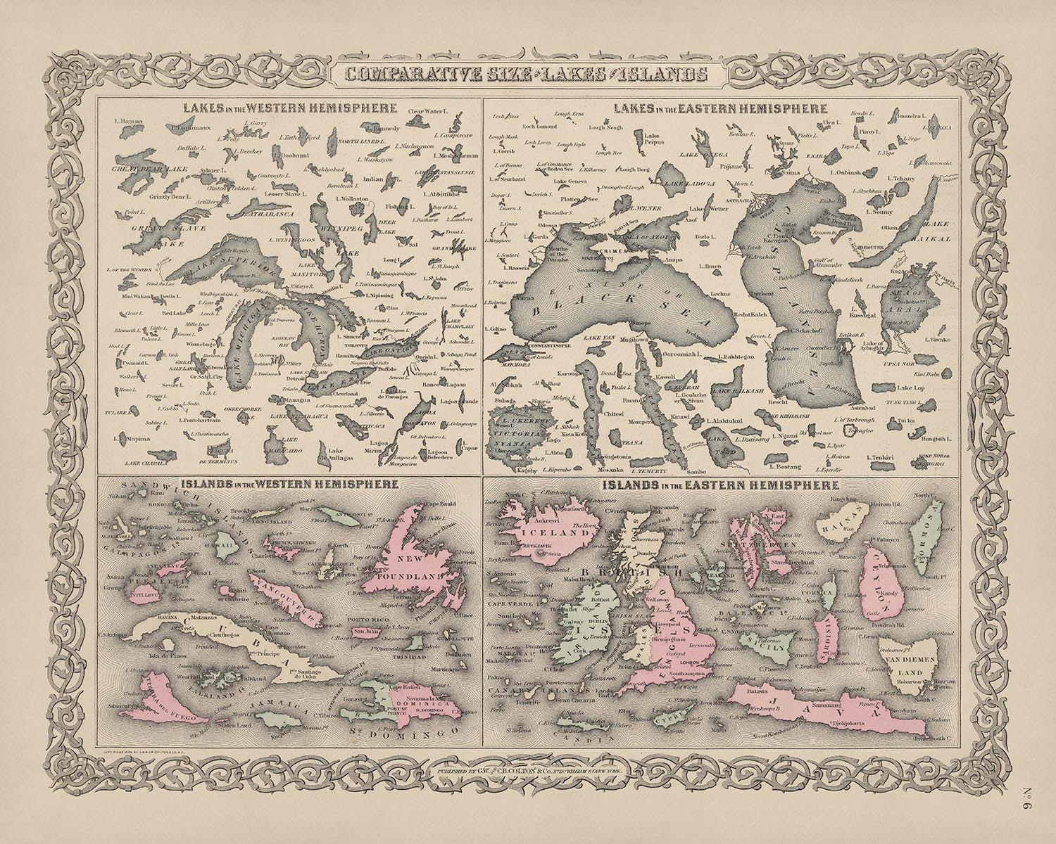
Betreten Sie die Welt der kartografischen Meisterschaft des späten 19. Jahrhunderts mit "Vergleichende Größe von Seen und Inseln der Welt", einer außergewöhnlichen...
WeiterlesenBetreten Sie die Welt der kartografischen Meisterschaft des späten 19. Jahrhunderts mit "Vergleichende Größe von Seen und Inseln der Welt", einer außergewöhnlichen Karte, die 1886 von der angesehenen Firma G.W. & C.B. Colton & Co. veröffentlicht wurde. Dieses fesselnde Werk, das in der Blütezeit der globalen Erkundung und wissenschaftlichen Neugier geschaffen wurde, bietet einen akribisch detaillierten visuellen Vergleich der größten Seen und Inseln des Planeten. Jedes Merkmal ist maßstabsgetreu gezeichnet und lädt den Betrachter ein, über die wahren Proportionen dieser Naturwunder nachzudenken - ein seltener Genuss sowohl für den erfahrenen Sammler als auch für den intellektuell Neugierigen.
Die Colton-Firma, die für ihre Präzision und Kunstfertigkeit bekannt ist, war ein Grundpfeiler der amerikanischen Kartografie im 19. Jahrhundert. Mit Sitz in der 182 William Street in New York waren die Coltons für einige der einflussreichsten Atlanten und thematischen Karten dieser Ära verantwortlich. Ihr Engagement für Genauigkeit und ästhetische Exzellenz zeigt sich in jedem Aspekt dieser Karte, von der sorgfältigen Anwendung von Farben bis hin zur Verwendung von Hachuren, einer künstlerischen Technik, die Relief und Tiefe in die Landschaft bringt. Diese Karte ist ein Zeugnis ihres bleibenden Erbes in den Annalen der Kartografie.
Was diese Karte besonders macht, ist ihr innovativer Ansatz zur geografischen Bildung. Anstatt sich auf politische Grenzen oder Städte zu konzentrieren, präsentiert sie ein globales Tableau der bedeutendsten Seen und Inseln der Erde, gruppiert nach Hemisphäre und in harmonischen Farben dargestellt. Die Karte zeigt nicht nur bekannte Riesen wie Grönland, Borneo und den Oberen See, sondern hebt auch weniger häufig dargestellte Merkmale wie den salzreichen Großen Salzsee und den Mono Lake hervor. Jeder Gewässer- und Landmasse ist so positioniert, dass sie einen direkten visuellen Vergleich ermöglicht, was diese Karte sowohl intellektuell anregend als auch visuell beeindruckend macht.
Ein besonders faszinierender Aspekt dieser Karte ist ihre Aufmerksamkeit für die einzigartigen hydrologischen Eigenschaften ausgewählter Gewässer. Das Schwarze Meer und das Kaspische Meer sind für ihre unterschiedlichen Salzgehalte bekannt - etwa die Hälfte bzw. ein Drittel des Salzgehalts von Meerwasser - während die Karte besondere Aufmerksamkeit auf die extreme Salinität des Großen Salzsees und des Mono Lake lenkt. Dieser Fokus auf die chemische Vielfalt der Seen der Welt unterstreicht die doppelte Rolle der Karte als wissenschaftliches Dokument und Kunstwerk und spiegelt den Geist der Neugier wider, der die späte viktorianische Ära prägte.
Obwohl die Karte global angelegt ist, verzichtet sie auf die Einbeziehung von Städten, Dörfern oder politischen Grenzen und bietet stattdessen eine reine Feier der natürlichen Formen der Erde. Vom eisigen Ausmaß Grönlands bis zu den üppigen Konturen Madagaskars und dem tiefen Blau des Baikalsees wird jedes Merkmal mit Klarheit und Ehrfurcht präsentiert. Für Sammler, Historiker und Geografie-Liebhaber bietet diese Karte nicht nur einen Blick in die physische Welt, wie sie 1886 verstanden wurde, sondern auch ein Stück kartografischer Geschichte, das die intellektuellen und künstlerischen Errungenschaften ihrer Zeit verkörpert.
Städte und Dörfer auf dieser Karte
- (Keine Städte oder Dörfer sind auf dieser Karte beschriftet oder sichtbar. Die Karte konzentriert sich ausschließlich auf die vergleichenden Größen von Seen und Inseln und schließt Siedlungen nicht ein.)
Bemerkenswerte Merkmale & Sehenswürdigkeiten
- Gewässer:
- Kaspisches Meer (bekannt für einen Salzgehalt von etwa einem Drittel des Salzgehalts von Meerwasser)
- Schwarzes Meer (bekannt für einen Salzgehalt von etwa der Hälfte des Salzgehalts von Meerwasser)
- Großer Salzsee (hochgradig salzhaltig)
- Mono Lake (hochgradig salzhaltig)
- Oberer See
- Michigansee
- Huronssee
- Eriesee
- Der Ontariosee
- Der Baikalsee
- Der Viktoriasee
- Der Tanganjikasee
- Der Nicaraguasee
- Der Titicacasee
- Das Aralsee
- Inseln:
- Großbritannien
- Kuba
- Island
- Java
- Neufundland
- Hainan
- Luzon
- Mindanao
- Irland
- Tasmanien
- Sri Lanka (Ceylon)
- Sizilien
- Sardinien
- Korsika
- Jamaika
- Zypern
- Illustrationen und Designelemente:
- Inseln und Seen sind maßstabsgetreu für einen direkten visuellen Vergleich gezeichnet.
- Deutliche Unterscheidung zwischen den Hemisphären (Nord- und Südhalbkugel).
- Künstlerische Verwendung von Farben und Hachuren, um Tiefe und visuelle Klarheit zu bieten.
Historischer und gestalterischer Kontext
- Veröffentlicht 1886 von G.W. & C.B. Colton & Co., einer angesehenen kartografischen Firma mit Sitz in New York.
- Teil eines späten Atlas, der das geografische Verständnis und die kartografischen Techniken des späten 19. Jahrhunderts widerspiegelt.
- Karte vergleicht visuell die Größen der wichtigsten Seen und Inseln weltweit, mit einem Fokus auf beide Hemisphären.
- Hebt die unterschiedlichen Salzgehalte bestimmter Seen und Meere hervor und bietet Bildungsinsights in geografische und hydrologische Eigenschaften.
- In voller Farbe mit detaillierten künstlerischen Techniken, einschließlich Hachuren zur Darstellung von Relief und Tiefe, erstellt.
- Dient sowohl als Bildungswerkzeug als auch als historisches Artefakt, das von Sammlern, Historikern und Geografie-Enthusiasten geschätzt wird.
Bitte überprüfen Sie die Bilder, um sicherzustellen, dass eine bestimmte Stadt oder ein Ort auf dieser Karte angezeigt wird. Sie können auch Kontakt aufnehmen und uns bitten, die Karte für Sie zu überprüfen.
Diese Karte sieht in jeder Größe großartig aus, aber ich empfehle immer, eine größere Größe zu wählen, wenn Sie Platz haben. So können Sie alle Details leicht erkennen.
Diese Karte sieht bis zu 50 Zoll (125 cm) erstaunlich aus. Wenn Sie nach einer größeren Karte suchen, bitte nehmen Sie Kontakt auf.
Das Modell in den Abbildungsbildern hält die 16x20 Zoll (40x50 cm) Version dieser Karte.
Das fünfte Abbildungsbild zeigt ein Beispiel meines Kartenpersonalisierungsdienstes.
Wenn Sie nach etwas leicht anderem suchen, schauen Sie sich meine Sammlung der besten alten Karten an, um zu sehen, ob etwas anderes Ihr Interesse weckt.
Bitte kontaktieren Sie mich, um zu überprüfen, ob ein bestimmter Standort, Wahrzeichen oder Merkmal auf dieser Karte angezeigt wird.
Dies wäre ein wunderbares Geburtstags-, Weihnachts-, Vatertags-, Abschieds-, Jubiläums- oder Einweihungsgeschenk für jemanden aus den in dieser Karte abgedeckten Gebieten.
Diese Karte ist als Giclée-Druck auf säurefreiem, archiviertem mattem Papier erhältlich, oder Sie können sie gerahmt kaufen. Der Rahmen ist ein schöner, einfacher schwarzer Rahmen, der zu den meisten Ästhetiken passt. Bitte nehmen Sie Kontakt auf, wenn Sie eine andere Rahmenfarbe oder -material wünschen. Meine Rahmen sind mit superklarem, museumsgrauem Acryl (Plexiglas/Acrylit) verglast, das deutlich weniger reflektierend als Glas ist, sicherer und immer in einwandfreiem Zustand ankommt.
This map is also available as a float framed canvas, sometimes known as a shadow gap framed canvas or canvas floater. The map is printed on artist's cotton canvas and then stretched over a handmade box frame. We then "float" the canvas inside a wooden frame, which is available in a range of colours (black, dark brown, oak, antique gold and white). This is a wonderful way to present a map without glazing in front. See some examples of float framed canvas maps and explore the differences between my different finishes.
For something truly unique, this map is also available in "Unique 3D", our trademarked process that dramatically transforms the map so that it has a wonderful sense of depth. We combine the original map with detailed topography and elevation data, so that mountains and the terrain really "pop". For more info and examples of 3D maps, check my Unique 3D page.
Betreten Sie die Welt der kartografischen Meisterschaft des späten 19. Jahrhunderts mit "Vergleichende Größe von Seen und Inseln der Welt", einer außergewöhnlichen Karte, die 1886 von der angesehenen Firma G.W. & C.B. Colton & Co. veröffentlicht wurde. Dieses fesselnde Werk, das in der Blütezeit der globalen Erkundung und wissenschaftlichen Neugier geschaffen wurde, bietet einen akribisch detaillierten visuellen Vergleich der größten Seen und Inseln des Planeten. Jedes Merkmal ist maßstabsgetreu gezeichnet und lädt den Betrachter ein, über die wahren Proportionen dieser Naturwunder nachzudenken - ein seltener Genuss sowohl für den erfahrenen Sammler als auch für den intellektuell Neugierigen.
Die Colton-Firma, die für ihre Präzision und Kunstfertigkeit bekannt ist, war ein Grundpfeiler der amerikanischen Kartografie im 19. Jahrhundert. Mit Sitz in der 182 William Street in New York waren die Coltons für einige der einflussreichsten Atlanten und thematischen Karten dieser Ära verantwortlich. Ihr Engagement für Genauigkeit und ästhetische Exzellenz zeigt sich in jedem Aspekt dieser Karte, von der sorgfältigen Anwendung von Farben bis hin zur Verwendung von Hachuren, einer künstlerischen Technik, die Relief und Tiefe in die Landschaft bringt. Diese Karte ist ein Zeugnis ihres bleibenden Erbes in den Annalen der Kartografie.
Was diese Karte besonders macht, ist ihr innovativer Ansatz zur geografischen Bildung. Anstatt sich auf politische Grenzen oder Städte zu konzentrieren, präsentiert sie ein globales Tableau der bedeutendsten Seen und Inseln der Erde, gruppiert nach Hemisphäre und in harmonischen Farben dargestellt. Die Karte zeigt nicht nur bekannte Riesen wie Grönland, Borneo und den Oberen See, sondern hebt auch weniger häufig dargestellte Merkmale wie den salzreichen Großen Salzsee und den Mono Lake hervor. Jeder Gewässer- und Landmasse ist so positioniert, dass sie einen direkten visuellen Vergleich ermöglicht, was diese Karte sowohl intellektuell anregend als auch visuell beeindruckend macht.
Ein besonders faszinierender Aspekt dieser Karte ist ihre Aufmerksamkeit für die einzigartigen hydrologischen Eigenschaften ausgewählter Gewässer. Das Schwarze Meer und das Kaspische Meer sind für ihre unterschiedlichen Salzgehalte bekannt - etwa die Hälfte bzw. ein Drittel des Salzgehalts von Meerwasser - während die Karte besondere Aufmerksamkeit auf die extreme Salinität des Großen Salzsees und des Mono Lake lenkt. Dieser Fokus auf die chemische Vielfalt der Seen der Welt unterstreicht die doppelte Rolle der Karte als wissenschaftliches Dokument und Kunstwerk und spiegelt den Geist der Neugier wider, der die späte viktorianische Ära prägte.
Obwohl die Karte global angelegt ist, verzichtet sie auf die Einbeziehung von Städten, Dörfern oder politischen Grenzen und bietet stattdessen eine reine Feier der natürlichen Formen der Erde. Vom eisigen Ausmaß Grönlands bis zu den üppigen Konturen Madagaskars und dem tiefen Blau des Baikalsees wird jedes Merkmal mit Klarheit und Ehrfurcht präsentiert. Für Sammler, Historiker und Geografie-Liebhaber bietet diese Karte nicht nur einen Blick in die physische Welt, wie sie 1886 verstanden wurde, sondern auch ein Stück kartografischer Geschichte, das die intellektuellen und künstlerischen Errungenschaften ihrer Zeit verkörpert.
Städte und Dörfer auf dieser Karte
- (Keine Städte oder Dörfer sind auf dieser Karte beschriftet oder sichtbar. Die Karte konzentriert sich ausschließlich auf die vergleichenden Größen von Seen und Inseln und schließt Siedlungen nicht ein.)
Bemerkenswerte Merkmale & Sehenswürdigkeiten
- Gewässer:
- Kaspisches Meer (bekannt für einen Salzgehalt von etwa einem Drittel des Salzgehalts von Meerwasser)
- Schwarzes Meer (bekannt für einen Salzgehalt von etwa der Hälfte des Salzgehalts von Meerwasser)
- Großer Salzsee (hochgradig salzhaltig)
- Mono Lake (hochgradig salzhaltig)
- Oberer See
- Michigansee
- Huronssee
- Eriesee
- Der Ontariosee
- Der Baikalsee
- Der Viktoriasee
- Der Tanganjikasee
- Der Nicaraguasee
- Der Titicacasee
- Das Aralsee
- Inseln:
- Großbritannien
- Kuba
- Island
- Java
- Neufundland
- Hainan
- Luzon
- Mindanao
- Irland
- Tasmanien
- Sri Lanka (Ceylon)
- Sizilien
- Sardinien
- Korsika
- Jamaika
- Zypern
- Illustrationen und Designelemente:
- Inseln und Seen sind maßstabsgetreu für einen direkten visuellen Vergleich gezeichnet.
- Deutliche Unterscheidung zwischen den Hemisphären (Nord- und Südhalbkugel).
- Künstlerische Verwendung von Farben und Hachuren, um Tiefe und visuelle Klarheit zu bieten.
Historischer und gestalterischer Kontext
- Veröffentlicht 1886 von G.W. & C.B. Colton & Co., einer angesehenen kartografischen Firma mit Sitz in New York.
- Teil eines späten Atlas, der das geografische Verständnis und die kartografischen Techniken des späten 19. Jahrhunderts widerspiegelt.
- Karte vergleicht visuell die Größen der wichtigsten Seen und Inseln weltweit, mit einem Fokus auf beide Hemisphären.
- Hebt die unterschiedlichen Salzgehalte bestimmter Seen und Meere hervor und bietet Bildungsinsights in geografische und hydrologische Eigenschaften.
- In voller Farbe mit detaillierten künstlerischen Techniken, einschließlich Hachuren zur Darstellung von Relief und Tiefe, erstellt.
- Dient sowohl als Bildungswerkzeug als auch als historisches Artefakt, das von Sammlern, Historikern und Geografie-Enthusiasten geschätzt wird.
Bitte überprüfen Sie die Bilder, um sicherzustellen, dass eine bestimmte Stadt oder ein Ort auf dieser Karte angezeigt wird. Sie können auch Kontakt aufnehmen und uns bitten, die Karte für Sie zu überprüfen.
Diese Karte sieht in jeder Größe großartig aus, aber ich empfehle immer, eine größere Größe zu wählen, wenn Sie Platz haben. So können Sie alle Details leicht erkennen.
Diese Karte sieht bis zu 50 Zoll (125 cm) erstaunlich aus. Wenn Sie nach einer größeren Karte suchen, bitte nehmen Sie Kontakt auf.
Das Modell in den Abbildungsbildern hält die 16x20 Zoll (40x50 cm) Version dieser Karte.
Das fünfte Abbildungsbild zeigt ein Beispiel meines Kartenpersonalisierungsdienstes.
Wenn Sie nach etwas leicht anderem suchen, schauen Sie sich meine Sammlung der besten alten Karten an, um zu sehen, ob etwas anderes Ihr Interesse weckt.
Bitte kontaktieren Sie mich, um zu überprüfen, ob ein bestimmter Standort, Wahrzeichen oder Merkmal auf dieser Karte angezeigt wird.
Dies wäre ein wunderbares Geburtstags-, Weihnachts-, Vatertags-, Abschieds-, Jubiläums- oder Einweihungsgeschenk für jemanden aus den in dieser Karte abgedeckten Gebieten.
Diese Karte ist als Giclée-Druck auf säurefreiem, archiviertem mattem Papier erhältlich, oder Sie können sie gerahmt kaufen. Der Rahmen ist ein schöner, einfacher schwarzer Rahmen, der zu den meisten Ästhetiken passt. Bitte nehmen Sie Kontakt auf, wenn Sie eine andere Rahmenfarbe oder -material wünschen. Meine Rahmen sind mit superklarem, museumsgrauem Acryl (Plexiglas/Acrylit) verglast, das deutlich weniger reflektierend als Glas ist, sicherer und immer in einwandfreiem Zustand ankommt.
This map is also available as a float framed canvas, sometimes known as a shadow gap framed canvas or canvas floater. The map is printed on artist's cotton canvas and then stretched over a handmade box frame. We then "float" the canvas inside a wooden frame, which is available in a range of colours (black, dark brown, oak, antique gold and white). This is a wonderful way to present a map without glazing in front. See some examples of float framed canvas maps and explore the differences between my different finishes.
For something truly unique, this map is also available in "Unique 3D", our trademarked process that dramatically transforms the map so that it has a wonderful sense of depth. We combine the original map with detailed topography and elevation data, so that mountains and the terrain really "pop". For more info and examples of 3D maps, check my Unique 3D page.
Many of our maps and art prints are chosen as thoughtful gifts for homes, offices, studies and meaningful places.
Choose a framed option for the easiest ready-to-hang gift, or choose an unframed print if the recipient may prefer to select their own frame.
We make orders locally in 23 countries around the world, so gifts can often be produced close to the recipient. This helps them arrive faster, travel more safely, and avoid customs or import duty surprises.
- We can deliver directly to the recipient
- Framed pieces arrive ready to hang
- Unframed prints are carefully packed in a strong protective tube
- Almost every order is made locally, for faster, safer gifting
- 90-day returns give the recipient time to decide
If you are not sure what to choose, please contact us. We can help you pick the right map, size, finish or delivery option.
Für die meisten Bestellungen beträgt die Lieferzeit etwa 3 Werktage. Personalisierte und maßgeschneiderte Produkte benötigen länger, da ich die Personalisierung durchführen und sie Ihnen zur Genehmigung zusenden muss, was normalerweise 1 oder 2 Tage dauert.
Bitte beachten Sie, dass sehr große gerahmte Bestellungen in der Regel länger für die Herstellung und Lieferung benötigen.
Wenn Sie möchten, dass Ihre Bestellung bis zu einem bestimmten Datum ankommt, bitte kontaktieren Sie mich, bevor Sie bestellen, damit wir den besten Weg finden können, um sicherzustellen, dass Sie Ihre Bestellung rechtzeitig erhalten.
Ich drucke und rahme Karten und Kunstwerke in 23 Ländern weltweit. Das bedeutet, dass Ihre Bestellung lokal gefertigt wird, was die Lieferzeit verkürzt und sicherstellt, dass sie während der Lieferung nicht beschädigt wird. Sie zahlen nie Zoll oder Einfuhrgebühren, und wir stoßen weniger CO2 in die Luft aus.
Alle meine Karten und Kunstdrucke sind gut verpackt und werden in einem robusten Rohr versendet, wenn sie ungerahmt sind, oder von Schaum umgeben, wenn sie gerahmt sind.
Ich versuche, alle Bestellungen innerhalb von 1 oder 2 Tagen nach Erhalt Ihrer Bestellung zu versenden, obwohl einige Produkte (wie Gesichtsmasken, Tassen und Tragetaschen) länger zur Herstellung benötigen können.
Wenn Sie Express-Lieferung an der Kasse auswählen, priorisieren wir Ihre Bestellung und versenden sie per 1-Tages-Kurier (Fedex, DHL, UPS, Parcelforce).
Nächster Tag Lieferung ist auch in einigen Ländern verfügbar (USA, UK, Singapur, VAE), aber bitte versuchen Sie, früh am Tag zu bestellen, damit wir es rechtzeitig versenden können.
Lesen Sie meinen vollständigen Leitfaden zur Lieferung und lokalen Produktion
Mein Standardrahmen ist ein Galerie-Stil-Rahmen aus schwarzem Eschenholz. Er ist einfach und sieht ziemlich modern aus. Mein Standardrahmen ist etwa 20 mm (0,8 Zoll) breit.
Ich verwende super-klares Acryl (Plexiglas/Acrylt) für das Glas des Rahmens. Es ist leichter und sicherer als Glas – und es sieht besser aus, da die Reflexion geringer ist.
Sechs Standardrahmenfarben sind kostenlos erhältlich (schwarz, dunkelbraun, dunkelgrau, Eiche, weiß und antikgold).
Die meisten Karten, Kunstwerke und Illustrationen sind auch als gerahmte Leinwand erhältlich. Wir verwenden matte (nicht glänzende) Baumwollleinwand, spannen sie über einen nachhaltig beschafften Buchenrahmen und 'schweben' dann das Stück innerhalb eines Holzrahmens. Das Endergebnis ist ziemlich schön, und es gibt keine Verglasung, die im Weg ist.
Alle Rahmen werden "bereit zum Aufhängen" geliefert, entweder mit einer Schnur oder Halterungen auf der Rückseite. Sehr große Rahmen haben schwere Aufhängeplatten und/oder eine Montageschiene. Wenn Sie Fragen haben, können Sie bitte Kontakt aufnehmen.
Sehen Sie sich einige Beispiele meiner gerahmten Karten und gerahmten Leinwandkarten an.
Alternativ kann ich auch alte Karten und Kunstwerke auf Leinwand, Schaumstoffplatten, Baumwollrag und andere Materialien liefern.
Wenn Sie Ihre Karte oder Ihr Kunstwerk selbst rahmen möchten, lesen Sie bitte zuerst meinen Größenleitfaden.
Meine Karten sind äußerst hochwertige Reproduktionen von Originalkarten.
Ich beziehe originale, seltene Karten aus Bibliotheken, Auktionshäusern und Privatsammlungen auf der ganzen Welt, restauriere sie in meiner Londoner Werkstatt und erstelle dann mit speziellen Giclée-Tinten und -Druckern wunderschöne Karten, die sogar noch besser aussehen als das Original.
Meine Karten werden auf säurefreiem, mattem Archivpapier (nicht glänzend) gedruckt, das sich sehr hochwertig anfühlt und fast wie Karton aussieht. Technisch gesehen beträgt das Papiergewicht/die Papierdicke 10mil/200g/m². Es eignet sich perfekt zum Einrahmen.
Ich drucke mit UV-lichtbeständigen Ultrachrome-Giclée-Pigmenttinten von Epson – einige der besten Tinten, die Sie finden können.
Ich kann auch machen Karten auf Leinwand, Baumwolllappen und andere exotische Materialien.
Erfahren Sie mehr über The Unique Maps Co.
Kartenpersonalisierung
Wenn Sie nach dem perfekten Geschenk zum Jahrestag oder zur Einweihung suchen, kann ich Ihre Karte personalisieren, um sie wirklich einzigartig zu machen. Ich kann beispielsweise eine kurze Nachricht hinzufügen, einen wichtigen Ort hervorheben oder das Wappen Ihrer Familie hinzufügen.
Die Möglichkeiten sind nahezu unbegrenzt. Bitte sehen Sie sich meine Kartenpersonalisierungsseite für einige wunderbare Beispiele dessen, was möglich ist.
Um eine personalisierte Karte zu bestellen, wählen Sie „Personalisieren Sie Ihre Karte“, bevor Sie sie in den Warenkorb legen.
In Kontakt kommen wenn Sie nach komplexeren Anpassungen und Personalisierungen suchen.
Kartenalterung
Im Laufe der Jahre wurde ich von Kunden hunderte Male gefragt, ob sie eine Karte kaufen könnten, die noch älter.
Nun, jetzt können Sie das, indem Sie „Alter“ auswählen, bevor Sie eine Karte in Ihren Warenkorb legen.
Alle Produktfotos, die Sie auf dieser Seite sehen, zeigen die Karte in ihrer Originalform. So sieht die Karte heute aus.
Wenn Sie „Gealtert“ auswählen, werde ich Ihre Karte von Hand altern lassen. Dazu verwende ich ein spezielles und einzigartiges Verfahren, das ich durch jahrelanges Studium alter Karten und Gespräche mit Forschern zum Verständnis der Chemie alternder Papiere entwickelt habe, und natürlich ... viel Übung!
Wenn Sie sich nicht sicher sind, bleiben Sie bei der Originalfarbe der Karte. Wenn Sie etwas Dunkleres und älter Wenn Sie auf der Suche sind, entscheiden Sie sich für „Aged“.
Sehen Sie einige erstaunliche Beispiele für gealterte Karten.
Wenn Sie aus irgendeinem Grund mit Ihrer Bestellung nicht zufrieden sind, kontaktieren Sie mich für eine unkomplizierte Rückerstattung. Bitte sehen Sie sich unsere Rückgabe- und Rückerstattungsrichtlinien für weitere Informationen an.
Ich bin sehr zuversichtlich, dass Ihnen Ihre restaurierte Karte oder Kunstdruck gefallen wird. Ich mache das seit 1984. Ich bin ein 5-Sterne Etsy-Verkäufer. Ich habe Zehntausende von Karten und Kunstdrucken verkauft und habe über 5.000 echte 5-Sterne-Bewertungen.
Ich verwende einen einzigartigen Prozess, um Karten und Kunstwerke zu restaurieren, der extrem zeitaufwendig und arbeitsintensiv ist. Die Suche nach den Originalkarten und Illustrationen kann Monate dauern. Ich benutze modernste und unglaublich teure Technologie, um sie zu scannen und wiederherzustellen. Daher garantiere ich, dass meine Karten und Kunstdrucke eine Klasse für sich sind - deshalb kann ich eine unkomplizierte Rückerstattung anbieten.
Fast alle meine Karten und Kunstdrucke sehen in großen Größen (200 cm, 6,5 Fuß+) erstaunlich aus und ich kann sie Ihnen auch gerahmt und über einen speziellen Übergrößen-Kurier liefern. Kontaktieren Sie mich, um Ihre speziellen Bedürfnisse zu besprechen.
Or try searching for something!


