


Bildliche Karte von South Carolina von Ruth Taylor White, 1935: Columbia, Charleston, Greenville, Atlantikküste, Landkreisgrenzen
20% Rabatt auf 2 — 33% Rabatt auf 3
Fügen Sie beliebige zwei berechtigte Artikel zu Ihrem Warenkorb hinzu, um 20% Rabatt zu erhalten. Fügen Sie einen dritten hinzu und er ist kostenlos (entspricht 33% Rabatt, wenn Sie drei kaufen).
Kein Code erforderlich — das Angebot wird automatisch an der Kasse angewendet.
Gültig für alle Standardkarten und Kunstdrucke. Sie können beliebige Designs kombinieren.
Wenn Sie Artikel an mehrere Adressen versenden möchten, kontaktieren Sie uns bitte, bevor Sie Ihre Bestellung aufgeben.
Maßanfertigungen und individuelle Aufträge sind ausgeschlossen.
Kontaktieren Sie uns wenn Sie Fragen haben
 In London gestaltet Hergestellt in the USA
In London gestaltet • Hergestellt in the USA
In London gestaltet Hergestellt in the USA
In London gestaltet • Hergestellt in the USA

Choose your size
Choose your finish


(Mehr Infos)
Geschenkmitteilung & individuelle Ausführung

Wenn Sie eine Geschenkmitteilung oder eine Ausführung (Puzzle, Aluminiumplatte usw.) hinzufügen möchten, die hier nicht verfügbar ist, geben Sie dies bitte in der "Bestellnotiz" beim Checkout an.
Jede Bestellung wird individuell angefertigt. Wenn Sie die Größe leicht anpassen oder auf einem ungewöhnlichen Material drucken lassen möchten, lassen Sie es uns einfach wissen. Wir haben im Laufe der Jahre Tausende von individuellen Bestellungen bearbeitet, daher gibt es (fast) nichts, was wir nicht bewältigen können.
Sie können uns auch kontaktieren, bevor Sie bestellen, wenn Sie möchten!

- Made locally for fast, safe delivery
- No import duty or hidden fees
- Need advice? Message us on WhatsApp
Own a piece of history
7,000+ 5 star reviews


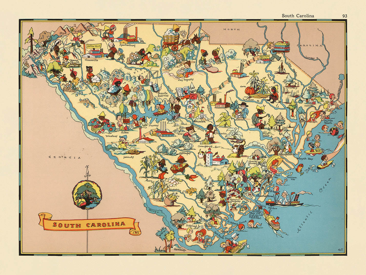
Betreten Sie die lebendige Welt Amerikas der 1930er Jahre mit „South Carolina“, einer fesselnden bildlichen Karte, die ursprünglich 1935 von Ruth Taylor White erstellt wurde. Dieses skurrile kartografische Schatzstück, Teil einer gefeierten Serie von Staatskarten, bietet ein reizvolles und aufschlussreiches Fenster in den Palmetto-Staat, wie er vor fast einem Jahrhundert wahrgenommen wurde. Der ursprüngliche Titel der Karte, einfach „South Carolina“, spricht für den Fokus auf die einzigartige Identität des Staates und lädt die Betrachter ein, seine Landkreise, Grenzen und reichhaltigen Charakter durch eine Vielzahl von charmanten Illustrationen zu erkunden. Jeder Zentimeter dieser Karte ist durchdrungen von der Energie und dem Optimismus ihrer Zeit, was sie zu einem faszinierenden Artefakt für Sammler und Liebhaber der amerikanischen Geschichte macht.
Ruth Taylor White, die kreative Kraft hinter dieser Karte, war bekannt für ihren einzigartigen Ansatz in der Kartografie. Ihre Karten sind sofort erkennbar durch ihre lebendigen Farbpaletten, verspielten Zeichnungen im Cartoon-Stil und ein Talent dafür, den Geist eines Ortes durch Kunst einzufangen. Gemeinsam mit ihrem Mann Frank Taylor half Ruth, bildliche Karten in den Vereinigten Staaten populär zu machen, indem sie geografische Genauigkeit mit fantasievoller Erzählkunst verband. Ihre South Carolina-Karte ist ein Zeugnis ihres Talents und bietet nicht nur ein Navigationswerkzeug, sondern auch eine lebendige Erzählung über das kulturelle und wirtschaftliche Leben des Staates während der Großen Depression.
Das Design dieser Karte ist nichts weniger als bezaubernd. Jeder Landkreis ist klar abgegrenzt, mit Grenzen und Namen sorgfältig beschriftet, während die üppigen Landschaften des Staates durch Illustrationen von Kiefernwäldern, sanften Feldern und der funkelnden Atlantikküste zum Leben erweckt werden. Das Fehlen moderner Autobahnen und Infrastruktur wird mehr als ausgeglichen durch den Reichtum an bildlichen Details – landwirtschaftliche Szenen, Vieh und lokale Industrien erscheinen alle und bieten einen Einblick in das ländliche und industrielle Erbe South Carolinas. Der Atlantische Ozean bildet eine elegante östliche Grenze, gesprenkelt mit Booten und Strandszenen, die auf die maritimen Traditionen des Staates hinweisen.
Ein Höhepunkt dieser Karte ist die Feier der Städte und Gemeinden South Carolinas, die jede mit liebevollen Details dargestellt sind. Von der geschäftigen Landeshauptstadt Columbia über die historischen Straßen von Charleston bis hin zu den lebendigen Gemeinschaften von Greenville, Spartanburg und darüber hinaus bietet die Karte eine Parade von Siedlungen, die das Schicksal des Staates geprägt haben. Die Einbeziehung so vieler Städte – groß und klein – unterstreicht die Vielfalt und den Reichtum der menschlichen Geographie South Carolinas. Diese Siedlungen sind kunstvoll in die Landschaft integriert, umgeben von Illustrationen, die das tägliche Leben, die Industrien und die Traditionen ihrer Bewohner hervorrufen.
Historisch gesehen ist diese Karte nicht nur aufgrund ihrer Kunstfertigkeit bedeutend, sondern auch wegen des Kontexts, in dem sie erstellt wurde. Sie wurde in einer Zeit wirtschaftlicher Not produziert und spiegelt sowohl die Widerstandsfähigkeit als auch die Bestrebungen der Südkaroliner in den 1930er Jahren wider. Die Bilder der Karte – die Baumwoll- und Tabakanbau, Textilfabriken und Freizeitaktivitäten darstellen – bieten ein visuelles Dokument der prägenden Industrien und kulturellen Eckpfeiler des Staates. Als Stück Americana steht sie sowohl als Feier als auch als Dokument ihrer Zeit und ist eine außergewöhnliche Ergänzung für jede Sammlung, die sich der Geschichte, Kunst oder Geographie des amerikanischen Südens widmet.
Städte und Gemeinden auf dieser Karte
- Columbia
- Charleston
- North Charleston
- Mount Pleasant
- Rock Hill
- Greenville
- Summerville
- Sumter
- Hilton Head Island
- Florenz
- Spartanburg
- Goose Creek
- Aiken
- Myrtle Beach
- Anderson
- Greer
- Greenwood
- Simpsonville
- Mauldin
- North Augusta
- Easley
- Hanahan
- Lexington
- Conway
- West Columbia
- North Myrtle Beach
- Clemson
- Orangeburg
- Cayce
- Bluffton
- Beaufort
- Gaffney
- Irmo
- Fort Mill
- Port Royal
- Forest Acres
- Newberry
- Bennettsville
- Chester
- Laurens
- Lancaster
- Hartsville
- Georgetown
- Union
- Walterboro
- Seneca
- Camden
- Darlington
- Moncks Corner
- Dillon
- Barnwell
- Abbeville
- Manning
- Batesburg-Leesville
- Winnsboro
- Chesterfield
- Kingstree
- Edgefield
- St. George
- Allendale
- Saluda
- McCormick
- Hampton
- Bamberg
- Ridgeland
- Fairfax
- Denmark
- Lake City
- Mullins
- Latta
- Pageland
- Cheraw
- Bishopville
- Timmonsville
- Woodruff
- Honea Path
- Williamston
- Travelers Rest
- Inman
- Landrum
- Fountain Inn
- Pickens
- Liberty
- Central
- Walhalla
- Westminster
- Belton
- Due West
- Ninety Six
- Clinton
- Jonesville
- Whitmire
- Great Falls
- Fort Lawn
- Kershaw
- Heath Springs
- Ridgeway
- Blythewood
- Prosperität
- Williston
- Blackville
- St. Matthews
- Santee
- Summerton
- Varnville
- Estill
- Kleiner Fluss
Bemerkenswerte Merkmale & Sehenswürdigkeiten
- Die Grenzen und Namen der Landkreise sind im gesamten Bundesstaat deutlich markiert.
- Der Atlantische Ozean wird entlang der östlichen Grenze von South Carolina dargestellt.
- Darstellungen landwirtschaftlicher Aktivitäten, wie Baumwoll- und Tabakanbau, sind prominent.
- Zeichnungen von Vieh, einschließlich Kühen und Pferden, sind in ländlichen Gebieten sichtbar.
- Bildliche Darstellungen von afroamerikanischen Arbeitern in landwirtschaftlichen Umgebungen.
- Bilder von Kiefern und Wäldern, die die natürlichen Ressourcen des Staates widerspiegeln.
- Illustrationen lokaler Industrien, wie Textilien und Holz.
- Darstellungen von Freizeitaktivitäten, einschließlich Jagen und Angeln.
- Künstlerische Darstellungen von Küsteneigenschaften, wie Stränden und Booten.
- Die Karte enthält eine dekorative Titelkartusche mit dem Namen und dem Schöpfer der Karte.
Historischer und gestalterischer Kontext
- Name der Karte: "South Carolina"
- Erstellungsdatum: 1935
- Kartenmacher: Ruth Taylor White, bekannt für ihre skurrilen, farbenfrohen bildlichen Karten.
- Die Karte verwendet lebendige, cartoonartige Illustrationen, um stereotype und kulturelle Elemente von South Carolina darzustellen, wie sie in den 1930er Jahren gesehen wurden.
- Hervorhebung kultureller, wirtschaftlicher und historischer Aspekte von South Carolina durch bildliche Darstellungen.
- Geografische Abdeckung: Der gesamte Bundesstaat South Carolina wird dargestellt, mit angezeigten Grenzen und Namen der Landkreise.
- Während der Großen Depression geschaffen, spiegelt die populäre Kultur und die sozialen Einstellungen der Zeit wider.
- Teil eines größeren Trends in den 1930er Jahren von bildlichen Karten, die Kunst und Geographie kombinierten, um Karten zugänglicher und ansprechender zu machen.
- Von Sammlern wegen ihrer einzigartigen Mischung aus Kunstfertigkeit, Geschichte und regionaler Identität begehrt.
- Dient als visuelles Lehrmittel, das den Charakter und die Identität South Carolinas zu Beginn des 20. Jahrhunderts veranschaulicht.
- Die Illustrationen spiegeln stereotype Vorstellungen der Zeit wider, die wichtig sind, um die kulturelle Perspektive der Epoche zu verstehen.
Bitte überprüfen Sie die Bilder, um sicherzustellen, dass eine bestimmte Stadt oder ein Ort auf dieser Karte angezeigt wird. Sie können uns auch kontaktieren und fragen, ob wir die Karte für Sie überprüfen können.
Diese Karte sieht in jeder Größe großartig aus, aber ich empfehle immer, eine größere Größe zu wählen, wenn Sie Platz haben. So können Sie alle Details leicht erkennen.
Diese Karte sieht bis zu 50 Zoll (125 cm) fantastisch aus. Wenn Sie nach einer größeren Karte suchen, bitte kontaktieren Sie uns.
Das Modell in den Angebotsbildern hält die 18x24 Zoll (45x60 cm) Version dieser Karte.
Das fünfte Angebotsbild zeigt ein Beispiel für meinen Personalisierungsservice für Karten.
Wenn Sie nach etwas leicht anderem suchen, schauen Sie sich meine Sammlung der besten alten Karten an, um zu sehen, ob Ihnen etwas anderes ins Auge fällt.
Bitte kontaktieren Sie mich, um zu überprüfen, ob ein bestimmter Standort, Wahrzeichen oder Merkmal auf dieser Karte angezeigt wird.
Dies wäre ein wunderbares Geburtstags-, Weihnachts-, Vatertags-, Abschieds-, Jubiläums- oder Einweihungsgeschenk für jemanden aus den von dieser Karte abgedeckten Gebieten.
Diese Karte ist als Giclée-Druck auf säurefreiem, archivierbarem mattem Papier erhältlich, oder Sie können sie gerahmt kaufen. Der Rahmen ist ein schöner, schlichter schwarzer Rahmen, der zu den meisten Ästhetiken passt. Bitte kontaktieren Sie mich, wenn Sie eine andere Rahmenfarbe oder -material wünschen. Meine Rahmen sind mit superklarem, museumsglanzendem Acryl (Plexiglas/Acrylt) verglast, das deutlich weniger reflektierend als Glas ist, sicherer ist und immer in einwandfreiem Zustand ankommt.
This map is also available as a float framed canvas, sometimes known as a shadow gap framed canvas or canvas floater. The map is printed on artist's cotton canvas and then stretched over a handmade box frame. We then "float" the canvas inside a wooden frame, which is available in a range of colours (black, dark brown, oak, antique gold and white). This is a wonderful way to present a map without glazing in front. See some examples of float framed canvas maps and explore the differences between my different finishes.
For something truly unique, this map is also available in "Unique 3D", our trademarked process that dramatically transforms the map so that it has a wonderful sense of depth. We combine the original map with detailed topography and elevation data, so that mountains and the terrain really "pop". For more info and examples of 3D maps, check my Unique 3D page.
Many of our maps and art prints are chosen as thoughtful gifts for homes, offices, studies and meaningful places.
Choose a framed option for the easiest ready-to-hang gift, or choose an unframed print if the recipient may prefer to select their own frame.
We make orders locally in 23 countries around the world, so gifts can often be produced close to the recipient. This helps them arrive faster, travel more safely, and avoid customs or import duty surprises.
- We can deliver directly to the recipient
- Framed pieces arrive ready to hang
- Unframed prints are carefully packed in a strong protective tube
- Almost every order is made locally, for faster, safer gifting
- 90-day returns give the recipient time to decide
If you are not sure what to choose, please contact us. We can help you pick the right map, size, finish or delivery option.
Für die meisten Bestellungen beträgt die Lieferzeit etwa 3 Werktage. Personalisierte und maßgeschneiderte Produkte benötigen länger, da ich die Personalisierung durchführen und sie Ihnen zur Genehmigung zusenden muss, was normalerweise 1 oder 2 Tage dauert.
Bitte beachten Sie, dass sehr große gerahmte Bestellungen in der Regel länger für die Herstellung und Lieferung benötigen.
Wenn Sie möchten, dass Ihre Bestellung bis zu einem bestimmten Datum ankommt, bitte kontaktieren Sie mich, bevor Sie bestellen, damit wir den besten Weg finden können, um sicherzustellen, dass Sie Ihre Bestellung rechtzeitig erhalten.
Ich drucke und rahme Karten und Kunstwerke in 23 Ländern weltweit. Das bedeutet, dass Ihre Bestellung lokal gefertigt wird, was die Lieferzeit verkürzt und sicherstellt, dass sie während der Lieferung nicht beschädigt wird. Sie zahlen nie Zoll oder Einfuhrgebühren, und wir stoßen weniger CO2 in die Luft aus.
Alle meine Karten und Kunstdrucke sind gut verpackt und werden in einem robusten Rohr versendet, wenn sie ungerahmt sind, oder von Schaum umgeben, wenn sie gerahmt sind.
Ich versuche, alle Bestellungen innerhalb von 1 oder 2 Tagen nach Erhalt Ihrer Bestellung zu versenden, obwohl einige Produkte (wie Gesichtsmasken, Tassen und Tragetaschen) länger zur Herstellung benötigen können.
Wenn Sie Express-Lieferung an der Kasse auswählen, priorisieren wir Ihre Bestellung und versenden sie per 1-Tages-Kurier (Fedex, DHL, UPS, Parcelforce).
Nächster Tag Lieferung ist auch in einigen Ländern verfügbar (USA, UK, Singapur, VAE), aber bitte versuchen Sie, früh am Tag zu bestellen, damit wir es rechtzeitig versenden können.
Lesen Sie meinen vollständigen Leitfaden zur Lieferung und lokalen Produktion
Mein Standardrahmen ist ein Galerie-Stil-Rahmen aus schwarzem Eschenholz. Er ist einfach und sieht ziemlich modern aus. Mein Standardrahmen ist etwa 20 mm (0,8 Zoll) breit.
Ich verwende super-klares Acryl (Plexiglas/Acrylt) für das Glas des Rahmens. Es ist leichter und sicherer als Glas – und es sieht besser aus, da die Reflexion geringer ist.
Sechs Standardrahmenfarben sind kostenlos erhältlich (schwarz, dunkelbraun, dunkelgrau, Eiche, weiß und antikgold).
Die meisten Karten, Kunstwerke und Illustrationen sind auch als gerahmte Leinwand erhältlich. Wir verwenden matte (nicht glänzende) Baumwollleinwand, spannen sie über einen nachhaltig beschafften Buchenrahmen und 'schweben' dann das Stück innerhalb eines Holzrahmens. Das Endergebnis ist ziemlich schön, und es gibt keine Verglasung, die im Weg ist.
Alle Rahmen werden "bereit zum Aufhängen" geliefert, entweder mit einer Schnur oder Halterungen auf der Rückseite. Sehr große Rahmen haben schwere Aufhängeplatten und/oder eine Montageschiene. Wenn Sie Fragen haben, können Sie bitte Kontakt aufnehmen.
Sehen Sie sich einige Beispiele meiner gerahmten Karten und gerahmten Leinwandkarten an.
Alternativ kann ich auch alte Karten und Kunstwerke auf Leinwand, Schaumstoffplatten, Baumwollrag und andere Materialien liefern.
Wenn Sie Ihre Karte oder Ihr Kunstwerk selbst rahmen möchten, lesen Sie bitte zuerst meinen Größenleitfaden.
Meine Karten sind äußerst hochwertige Reproduktionen von Originalkarten.
Ich beziehe originale, seltene Karten aus Bibliotheken, Auktionshäusern und Privatsammlungen auf der ganzen Welt, restauriere sie in meiner Londoner Werkstatt und erstelle dann mit speziellen Giclée-Tinten und -Druckern wunderschöne Karten, die sogar noch besser aussehen als das Original.
Meine Karten werden auf säurefreiem, mattem Archivpapier (nicht glänzend) gedruckt, das sich sehr hochwertig anfühlt und fast wie Karton aussieht. Technisch gesehen beträgt das Papiergewicht/die Papierdicke 10mil/200g/m². Es eignet sich perfekt zum Einrahmen.
Ich drucke mit UV-lichtbeständigen Ultrachrome-Giclée-Pigmenttinten von Epson – einige der besten Tinten, die Sie finden können.
Ich kann auch machen Karten auf Leinwand, Baumwolllappen und andere exotische Materialien.
Erfahren Sie mehr über The Unique Maps Co.
Kartenpersonalisierung
Wenn Sie nach dem perfekten Geschenk zum Jahrestag oder zur Einweihung suchen, kann ich Ihre Karte personalisieren, um sie wirklich einzigartig zu machen. Ich kann beispielsweise eine kurze Nachricht hinzufügen, einen wichtigen Ort hervorheben oder das Wappen Ihrer Familie hinzufügen.
Die Möglichkeiten sind nahezu unbegrenzt. Bitte sehen Sie sich meine Kartenpersonalisierungsseite für einige wunderbare Beispiele dessen, was möglich ist.
Um eine personalisierte Karte zu bestellen, wählen Sie „Personalisieren Sie Ihre Karte“, bevor Sie sie in den Warenkorb legen.
In Kontakt kommen wenn Sie nach komplexeren Anpassungen und Personalisierungen suchen.
Kartenalterung
Im Laufe der Jahre wurde ich von Kunden hunderte Male gefragt, ob sie eine Karte kaufen könnten, die noch älter.
Nun, jetzt können Sie das, indem Sie „Alter“ auswählen, bevor Sie eine Karte in Ihren Warenkorb legen.
Alle Produktfotos, die Sie auf dieser Seite sehen, zeigen die Karte in ihrer Originalform. So sieht die Karte heute aus.
Wenn Sie „Gealtert“ auswählen, werde ich Ihre Karte von Hand altern lassen. Dazu verwende ich ein spezielles und einzigartiges Verfahren, das ich durch jahrelanges Studium alter Karten und Gespräche mit Forschern zum Verständnis der Chemie alternder Papiere entwickelt habe, und natürlich ... viel Übung!
Wenn Sie sich nicht sicher sind, bleiben Sie bei der Originalfarbe der Karte. Wenn Sie etwas Dunkleres und älter Wenn Sie auf der Suche sind, entscheiden Sie sich für „Aged“.
Sehen Sie einige erstaunliche Beispiele für gealterte Karten.
Wenn Sie aus irgendeinem Grund mit Ihrer Bestellung nicht zufrieden sind, kontaktieren Sie mich für eine unkomplizierte Rückerstattung. Bitte sehen Sie sich unsere Rückgabe- und Rückerstattungsrichtlinien für weitere Informationen an.
Ich bin sehr zuversichtlich, dass Ihnen Ihre restaurierte Karte oder Kunstdruck gefallen wird. Ich mache das seit 1984. Ich bin ein 5-Sterne Etsy-Verkäufer. Ich habe Zehntausende von Karten und Kunstdrucken verkauft und habe über 5.000 echte 5-Sterne-Bewertungen.
Ich verwende einen einzigartigen Prozess, um Karten und Kunstwerke zu restaurieren, der extrem zeitaufwendig und arbeitsintensiv ist. Die Suche nach den Originalkarten und Illustrationen kann Monate dauern. Ich benutze modernste und unglaublich teure Technologie, um sie zu scannen und wiederherzustellen. Daher garantiere ich, dass meine Karten und Kunstdrucke eine Klasse für sich sind - deshalb kann ich eine unkomplizierte Rückerstattung anbieten.
Fast alle meine Karten und Kunstdrucke sehen in großen Größen (200 cm, 6,5 Fuß+) erstaunlich aus und ich kann sie Ihnen auch gerahmt und über einen speziellen Übergrößen-Kurier liefern. Kontaktieren Sie mich, um Ihre speziellen Bedürfnisse zu besprechen.
Or try searching for something!


