


Alte Militär- und Straßenkarte von Carcassonne von Viollet-le-Duc, 1854: Cité-Befestigungen, Schloss, Basilika
20% Rabatt auf 2 — 33% Rabatt auf 3
Fügen Sie beliebige zwei berechtigte Artikel zu Ihrem Warenkorb hinzu, um 20% Rabatt zu erhalten. Fügen Sie einen dritten hinzu und er ist kostenlos (entspricht 33% Rabatt, wenn Sie drei kaufen).
Kein Code erforderlich — das Angebot wird automatisch an der Kasse angewendet.
Gültig für alle Standardkarten und Kunstdrucke. Sie können beliebige Designs kombinieren.
Wenn Sie Artikel an mehrere Adressen versenden möchten, kontaktieren Sie uns bitte, bevor Sie Ihre Bestellung aufgeben.
Maßanfertigungen und individuelle Aufträge sind ausgeschlossen.
Kontaktieren Sie uns wenn Sie Fragen haben
 In London gestaltet Hergestellt in the USA
In London gestaltet • Hergestellt in the USA
In London gestaltet Hergestellt in the USA
In London gestaltet • Hergestellt in the USA

Aus der Originalkarte von 1854 restauriert und in Museumsqualität gedruckt. Die Geschichte hinter dieser Karte lesen
Choose your size
Choose your finish


(Mehr Infos)
Geschenkmitteilung & individuelle Ausführung

Wenn Sie eine Geschenkmitteilung oder eine Ausführung (Puzzle, Aluminiumplatte usw.) hinzufügen möchten, die hier nicht verfügbar ist, geben Sie dies bitte in der "Bestellnotiz" beim Checkout an.
Jede Bestellung wird individuell angefertigt. Wenn Sie die Größe leicht anpassen oder auf einem ungewöhnlichen Material drucken lassen möchten, lassen Sie es uns einfach wissen. Wir haben im Laufe der Jahre Tausende von individuellen Bestellungen bearbeitet, daher gibt es (fast) nichts, was wir nicht bewältigen können.
Sie können uns auch kontaktieren, bevor Sie bestellen, wenn Sie möchten!

- Lokal gefertigt. Sicher geliefert
- Keine Zölle oder versteckten Gebühren
- Hilfe nötig? Rufen Sie uns an oder WhatsApp schreiben
Own a piece of history
8,000+ five-star reviews


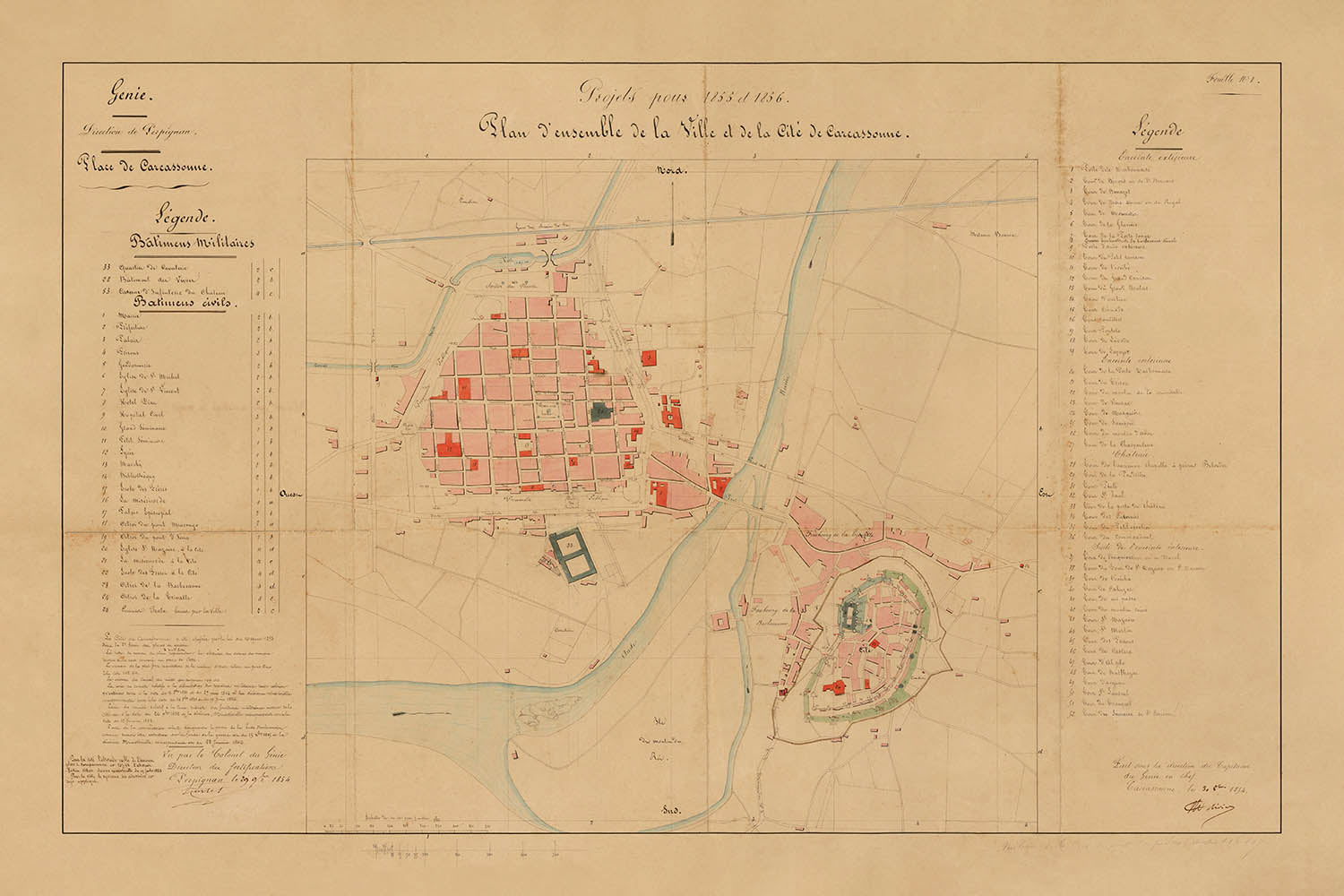
Der „Plan d'ensemble de la Ville et de la Cité de Carcassonne“, der 1854 unter der Leitung von Eugène-Emmanuel Viollet-le-Duc und Colonel...
WeiterlesenDer „Plan d'ensemble de la Ville et de la Cité de Carcassonne“, der 1854 unter der Leitung von Eugène-Emmanuel Viollet-le-Duc und Colonel de Rivieres erstellt wurde, ist ein bemerkenswerter Beweis für das Zusammentreffen von Stadtgeschichte, Militärarchitektur und der aufkommenden Wissenschaft der Denkmalpflege. Diese handschriftliche Stadtkarte erfasst Carcassonne in einem entscheidenden Moment—gerade als die weltbekannte Restaurierung beginnen sollte—und bietet einen seltenen und authentischen Schnappschuss der mittelalterlichen Befestigungen der Stadt, der lebhaften Unterstadt und des komplexen Zusammenspiels zwischen alten und modernen Stadtformen. Der ursprüngliche französische Titel selbst ruft die umfassende Vision seiner Schöpfer hervor, die jeden Bastion, jede Brücke und jeden Boulevard sorgfältig dokumentierten, um sich auf die bevorstehenden umfassenden Veränderungen vorzubereiten.
Was diese Stadtkarte besonders macht, ist ihr doppelter Fokus: die befestigte Cité de Carcassonne, ein konzentrisches Wunderwerk mittelalterlicher Militärtechnik, und die Ville Basse, die lebendige Unterstadt jenseits des Flusses Aude. Die detaillierte Darstellung der doppelt ummauerten Cité, komplett mit Türmen, Vorwerken und dem imposanten Château Comtal, offenbart die formidable Verteidigung der Stadt—die während des Hundertjährigen Krieges nie durchbrochen und praktisch unberührt von dem berüchtigten Überfall des Schwarzen Prinzen blieb. Wahrzeichen wie die Basilika Saint-Nazaire, die zu diesem Zeitpunkt bereits restauriert wurde, sind deutlich markiert und heben das reiche religiöse und architektonische Erbe der Stadt hervor.
Die Kunstfertigkeit der Karte liegt nicht nur in ihrer präzisen Abgrenzung der Befestigungen, sondern auch in ihrer durchdachten Darstellung des zivilen Lebens in Carcassonne. Die Ville Basse ist mit gleicher Sorgfalt kartiert, ihr mittelalterliches Straßennetz und die prominenten Plätze—wie der Place Carnot und der Place Gambetta—sprechen von Jahrhunderten der bürgerlichen Evolution. Die eleganten Kurven des Flusses Aude und die eleganten Überquerungen der Pont Vieux und Pont Neuf verbinden die alte Cité mit den lebhaften Vierteln der Unterstadt und veranschaulichen die dynamische Beziehung der Stadt zu ihrer Landschaft und ihren Wasserwegen. Solche Merkmale machen diese Karte zu einer unschätzbaren Ressource für jeden, der von den geschichtlichen Schichten europäischer Städte fasziniert ist.
Historisch gesehen ist diese Karte von tiefgreifender Bedeutung. Sie wurde zu Beginn von Viollet-le-Ducs fünfzigjährigen Restaurierungskampagne erstellt und dokumentiert Carcassonne, wie es vor der Entfernung späterer Strukturen und der sorgfältigen Rehabilitation seiner Mauern, Türme und Tore existierte. Die Anmerkungen und die farbcodierte Legende, die zivile und militärische Befestigungen unterscheiden, spiegeln die akribische Planung und Vision wider, die letztendlich Carcassonne vor dem Ruin bewahrte. Infolgedessen kartiert diese Karte nicht nur die physischen Konturen einer Stadt, sondern auch die intellektuellen und kulturellen Strömungen, die die moderne Praxis der Denkmalpflege prägten.
Eugène-Emmanuel Viollet-le-Duc, der leitende Geist der Karte, war ein visionärer Architekt, dessen Arbeit in Carcassonne die Prinzipien der Denkmalpflege weltweit beeinflusste. Bekannt für seine interpretativen Restaurierungen von Notre Dame de Paris, Mont Saint-Michel und anderen französischen Ikonen, ging Viollet-le-Duc mit sowohl wissenschaftlicher Strenge als auch kreativer Vorstellungskraft an Carcassonne heran. Sein Erbe, das in dieser außergewöhnlichen Karte bewahrt ist, besteht nicht nur aus Stein und Mörtel, sondern aus einer tiefen Ehrfurcht vor der Geschichte, der städtischen Form und der anhaltenden Kraft des Ortes. Für Sammler, Historiker und Kenner kartografischer Kunst bietet diese Karte eine seltene Gelegenheit, ein Stück der lebendigen Geschichte von Carcassonne zu besitzen—einer Stadt, deren Mauern den Wandel von Reichen, Glaubensrichtungen und Jahrhunderten miterlebt haben.
Straßen und Wege auf dieser Karte
- Allée des Soupirs
- Avenue de la Gare
- Avenue du Pont Neuf
- Boulevard Barbès
- Boulevard de la Bastide
- Boulevard de la Cité
- Boulevard de la Préfecture
- Boulevard du Canal
- Boulevard du Commandant Roumens
- Boulevard Marcou
- Boulevard Omer Sarraut
- Boulevard Pasteur
- Boulevard Paul Sabatier
- Boulevard Pierre Curie
- Boulevard Voltaire
- Chemin de la Cité
- Chemin de la Madeleine
- Chemin du Pont Vieux
- Place Carnot
- Place Davilla
- Place Eggenfelden
- Place Gambetta
- Place Marcou
- Place Saint-Gimer
- Place Saint-Louis
- Pont Neuf
- Pont Vieux
- Rue Aimé Ramond
- Rue de la Barbacane
- Rue de Verdun
Bemerkenswerte Merkmale & Wahrzeichen
- Die befestigte Cité de Carcassonne mit ihrem doppelten Ring aus Mauern und zahlreichen Türmen
- Die Basilika Saint-Nazaire (mit der Nummer #20 in Rot gekennzeichnet), ein bedeutendes religiöses und architektonisches Wahrzeichen
- Das Château Comtal (Grafenschloss) innerhalb der Cité
- Die Ville Basse (untere Stadt) gegenüber dem Fluss von der Cité
- Der Aude-Fluss, der die Cité von der Ville Basse trennt
- Brücken über den Aude-Fluss, die die Cité und die Ville Basse verbinden
- Stadttore, einschließlich der Porte Narbonnaise und der Porte de l'Aude
- Öffentliche und militärische Befestigungen, farblich gekennzeichnet und annotiert
- Ein detaillierter Schlüssel/Legende auf der linken Seite der Karte
- Umfangreiche Anmerkungen und Projektnotizen in der unteren linken Ecke
- Verteidigungstürme und Bastionen entlang der Mauern
- Der Bereich zwischen den beiden Linien von Mauern (die „Listen“), der später während der Restaurierung von Häusern geräumt wurde
- Prominente Freiflächen und Plätze innerhalb der Stadt
- Das konzentrische Design der Befestigungen der Cité
- Der rechteckige befestigte Bereich des Schlosses
- Das mittelalterliche Straßennetz der Ville Basse
- Der Uferbereich und die Deiche entlang der Aude
Historischer und gestalterischer Kontext
- Erstellt im Jahr 1854 unter der Leitung von Eugène-Emmanuel Viollet-le-Duc und Colonel de Rivieres, als Teil der Restaurierungsplanung für Carcassonne.
- Dokumentiert Carcassonne zu Beginn seiner einflussreichen Restaurierung im 19. Jahrhundert, vor bedeutenden Veränderungen und Abrissen.
- Zeigt sowohl die befestigte Cité als auch die Ville Basse und fängt den dualen Charakter der Stadt ein.
- Enthält ein großes Manuskript-Design mit farblich gekennzeichneten zivilen und militärischen Befestigungen sowie einer umfassenden Legende.
- Spiegelt die intellektuelle und kulturelle Bewegung im Frankreich des 19. Jahrhunderts wider, die darauf abzielte, mittelalterliche Denkmäler zu bewahren und zu restaurieren.
- Viollet-le-Ducs Restaurierung von Carcassonne wurde zu einem Modell für moderne Konservierungspraktiken und hatte einen tiefgreifenden Einfluss auf den Denkmalschutz.
- Die Karte ist ein offizielles Artefakt, das vom Colonel der Stadt unterzeichnet wurde, und wurde für die Stadtplanung während der Herrschaft von Napoleon III. verwendet.
- Carcassonne ist ein UNESCO-Weltkulturerbe, das für seine außergewöhnlichen mittelalterlichen Befestigungen und das Erbe der Restaurierung gefeiert wird.
Bitte überprüfen Sie die Bilder, um sicherzustellen, dass eine bestimmte Stadt oder ein Ort auf dieser Karte dargestellt ist. Sie können uns auch kontaktieren und bitten, die Karte für Sie zu überprüfen.
Diese Karte sieht in jeder Größe großartig aus, aber ich empfehle immer, eine größere Größe zu wählen, wenn Sie Platz haben. So können Sie alle Details leicht erkennen.
Diese Karte sieht in Größen bis zu 50 Zoll (125 cm) großartig aus. Wenn Sie nach einer größeren Karte suchen, bitte nehmen Sie Kontakt auf.
Bitte beachten Sie: Die Beschriftungen auf dieser Karte sind schwer zu lesen, wenn Sie eine Karte bestellen, die 16 Zoll (40 cm) oder kleiner ist. Die Karte ist immer noch sehr ansprechend, aber wenn Sie die Karte leicht lesen möchten, kaufen Sie bitte eine größere Größe.
Das Modell in den Angebotsbildern hält die 24x36 Zoll (60x90 cm) Version dieser Karte.
Das fünfte Angebotsbild zeigt ein Beispiel meines Personalisierungsservices für Karten.
Wenn Sie nach etwas leicht anderem suchen, schauen Sie sich meine Sammlung der besten alten Karten an, um zu sehen, ob etwas anderes Ihr Interesse weckt.
Bitte kontaktieren Sie mich, um zu überprüfen, ob ein bestimmter Ort, Wahrzeichen oder Merkmal auf dieser Karte dargestellt ist.
Dies wäre ein wunderbares Geschenk zum Geburtstag, Weihnachten, Vatertag, zum Abschied von der Arbeit, zum Jubiläum oder zur Einweihung für jemanden aus den Gebieten, die von dieser Karte abgedeckt werden.
Diese Karte ist als Giclée-Druck auf säurefreiem, archivierbarem, mattem Papier erhältlich, oder Sie können sie gerahmt kaufen. Der Rahmen ist ein schöner, einfacher schwarzer Rahmen, der zu den meisten Ästhetiken passt. Bitte nehmen Sie Kontakt auf, wenn Sie eine andere Rahmenfarbe oder -material wünschen. Meine Rahmen sind mit superklarem, museumsgüte Acryl (Plexiglas/Acryli) verglast, das deutlich weniger reflektierend ist als Glas, sicherer ist und immer in einwandfreiem Zustand ankommt.
This map is also available as a float framed canvas, sometimes known as a shadow gap framed canvas or canvas floater. The map is printed on artist's cotton canvas and then stretched over a handmade box frame. We then "float" the canvas inside a wooden frame, which is available in a range of colours (black, dark brown, oak, antique gold and white). This is a wonderful way to present a map without glazing in front. See some examples of float framed canvas maps and explore the differences between my different finishes.
For something truly unique, this map is also available in "Unique 3D", our trademarked process that dramatically transforms the map so that it has a wonderful sense of depth. We combine the original map with detailed topography and elevation data, so that mountains and the terrain really "pop". For more info and examples of 3D maps, check my Unique 3D page.
Der „Plan d'ensemble de la Ville et de la Cité de Carcassonne“, der 1854 unter der Leitung von Eugène-Emmanuel Viollet-le-Duc und Colonel de Rivieres erstellt wurde, ist ein bemerkenswerter Beweis für das Zusammentreffen von Stadtgeschichte, Militärarchitektur und der aufkommenden Wissenschaft der Denkmalpflege. Diese handschriftliche Stadtkarte erfasst Carcassonne in einem entscheidenden Moment—gerade als die weltbekannte Restaurierung beginnen sollte—und bietet einen seltenen und authentischen Schnappschuss der mittelalterlichen Befestigungen der Stadt, der lebhaften Unterstadt und des komplexen Zusammenspiels zwischen alten und modernen Stadtformen. Der ursprüngliche französische Titel selbst ruft die umfassende Vision seiner Schöpfer hervor, die jeden Bastion, jede Brücke und jeden Boulevard sorgfältig dokumentierten, um sich auf die bevorstehenden umfassenden Veränderungen vorzubereiten.
Was diese Stadtkarte besonders macht, ist ihr doppelter Fokus: die befestigte Cité de Carcassonne, ein konzentrisches Wunderwerk mittelalterlicher Militärtechnik, und die Ville Basse, die lebendige Unterstadt jenseits des Flusses Aude. Die detaillierte Darstellung der doppelt ummauerten Cité, komplett mit Türmen, Vorwerken und dem imposanten Château Comtal, offenbart die formidable Verteidigung der Stadt—die während des Hundertjährigen Krieges nie durchbrochen und praktisch unberührt von dem berüchtigten Überfall des Schwarzen Prinzen blieb. Wahrzeichen wie die Basilika Saint-Nazaire, die zu diesem Zeitpunkt bereits restauriert wurde, sind deutlich markiert und heben das reiche religiöse und architektonische Erbe der Stadt hervor.
Die Kunstfertigkeit der Karte liegt nicht nur in ihrer präzisen Abgrenzung der Befestigungen, sondern auch in ihrer durchdachten Darstellung des zivilen Lebens in Carcassonne. Die Ville Basse ist mit gleicher Sorgfalt kartiert, ihr mittelalterliches Straßennetz und die prominenten Plätze—wie der Place Carnot und der Place Gambetta—sprechen von Jahrhunderten der bürgerlichen Evolution. Die eleganten Kurven des Flusses Aude und die eleganten Überquerungen der Pont Vieux und Pont Neuf verbinden die alte Cité mit den lebhaften Vierteln der Unterstadt und veranschaulichen die dynamische Beziehung der Stadt zu ihrer Landschaft und ihren Wasserwegen. Solche Merkmale machen diese Karte zu einer unschätzbaren Ressource für jeden, der von den geschichtlichen Schichten europäischer Städte fasziniert ist.
Historisch gesehen ist diese Karte von tiefgreifender Bedeutung. Sie wurde zu Beginn von Viollet-le-Ducs fünfzigjährigen Restaurierungskampagne erstellt und dokumentiert Carcassonne, wie es vor der Entfernung späterer Strukturen und der sorgfältigen Rehabilitation seiner Mauern, Türme und Tore existierte. Die Anmerkungen und die farbcodierte Legende, die zivile und militärische Befestigungen unterscheiden, spiegeln die akribische Planung und Vision wider, die letztendlich Carcassonne vor dem Ruin bewahrte. Infolgedessen kartiert diese Karte nicht nur die physischen Konturen einer Stadt, sondern auch die intellektuellen und kulturellen Strömungen, die die moderne Praxis der Denkmalpflege prägten.
Eugène-Emmanuel Viollet-le-Duc, der leitende Geist der Karte, war ein visionärer Architekt, dessen Arbeit in Carcassonne die Prinzipien der Denkmalpflege weltweit beeinflusste. Bekannt für seine interpretativen Restaurierungen von Notre Dame de Paris, Mont Saint-Michel und anderen französischen Ikonen, ging Viollet-le-Duc mit sowohl wissenschaftlicher Strenge als auch kreativer Vorstellungskraft an Carcassonne heran. Sein Erbe, das in dieser außergewöhnlichen Karte bewahrt ist, besteht nicht nur aus Stein und Mörtel, sondern aus einer tiefen Ehrfurcht vor der Geschichte, der städtischen Form und der anhaltenden Kraft des Ortes. Für Sammler, Historiker und Kenner kartografischer Kunst bietet diese Karte eine seltene Gelegenheit, ein Stück der lebendigen Geschichte von Carcassonne zu besitzen—einer Stadt, deren Mauern den Wandel von Reichen, Glaubensrichtungen und Jahrhunderten miterlebt haben.
Straßen und Wege auf dieser Karte
- Allée des Soupirs
- Avenue de la Gare
- Avenue du Pont Neuf
- Boulevard Barbès
- Boulevard de la Bastide
- Boulevard de la Cité
- Boulevard de la Préfecture
- Boulevard du Canal
- Boulevard du Commandant Roumens
- Boulevard Marcou
- Boulevard Omer Sarraut
- Boulevard Pasteur
- Boulevard Paul Sabatier
- Boulevard Pierre Curie
- Boulevard Voltaire
- Chemin de la Cité
- Chemin de la Madeleine
- Chemin du Pont Vieux
- Place Carnot
- Place Davilla
- Place Eggenfelden
- Place Gambetta
- Place Marcou
- Place Saint-Gimer
- Place Saint-Louis
- Pont Neuf
- Pont Vieux
- Rue Aimé Ramond
- Rue de la Barbacane
- Rue de Verdun
Bemerkenswerte Merkmale & Wahrzeichen
- Die befestigte Cité de Carcassonne mit ihrem doppelten Ring aus Mauern und zahlreichen Türmen
- Die Basilika Saint-Nazaire (mit der Nummer #20 in Rot gekennzeichnet), ein bedeutendes religiöses und architektonisches Wahrzeichen
- Das Château Comtal (Grafenschloss) innerhalb der Cité
- Die Ville Basse (untere Stadt) gegenüber dem Fluss von der Cité
- Der Aude-Fluss, der die Cité von der Ville Basse trennt
- Brücken über den Aude-Fluss, die die Cité und die Ville Basse verbinden
- Stadttore, einschließlich der Porte Narbonnaise und der Porte de l'Aude
- Öffentliche und militärische Befestigungen, farblich gekennzeichnet und annotiert
- Ein detaillierter Schlüssel/Legende auf der linken Seite der Karte
- Umfangreiche Anmerkungen und Projektnotizen in der unteren linken Ecke
- Verteidigungstürme und Bastionen entlang der Mauern
- Der Bereich zwischen den beiden Linien von Mauern (die „Listen“), der später während der Restaurierung von Häusern geräumt wurde
- Prominente Freiflächen und Plätze innerhalb der Stadt
- Das konzentrische Design der Befestigungen der Cité
- Der rechteckige befestigte Bereich des Schlosses
- Das mittelalterliche Straßennetz der Ville Basse
- Der Uferbereich und die Deiche entlang der Aude
Historischer und gestalterischer Kontext
- Erstellt im Jahr 1854 unter der Leitung von Eugène-Emmanuel Viollet-le-Duc und Colonel de Rivieres, als Teil der Restaurierungsplanung für Carcassonne.
- Dokumentiert Carcassonne zu Beginn seiner einflussreichen Restaurierung im 19. Jahrhundert, vor bedeutenden Veränderungen und Abrissen.
- Zeigt sowohl die befestigte Cité als auch die Ville Basse und fängt den dualen Charakter der Stadt ein.
- Enthält ein großes Manuskript-Design mit farblich gekennzeichneten zivilen und militärischen Befestigungen sowie einer umfassenden Legende.
- Spiegelt die intellektuelle und kulturelle Bewegung im Frankreich des 19. Jahrhunderts wider, die darauf abzielte, mittelalterliche Denkmäler zu bewahren und zu restaurieren.
- Viollet-le-Ducs Restaurierung von Carcassonne wurde zu einem Modell für moderne Konservierungspraktiken und hatte einen tiefgreifenden Einfluss auf den Denkmalschutz.
- Die Karte ist ein offizielles Artefakt, das vom Colonel der Stadt unterzeichnet wurde, und wurde für die Stadtplanung während der Herrschaft von Napoleon III. verwendet.
- Carcassonne ist ein UNESCO-Weltkulturerbe, das für seine außergewöhnlichen mittelalterlichen Befestigungen und das Erbe der Restaurierung gefeiert wird.
Bitte überprüfen Sie die Bilder, um sicherzustellen, dass eine bestimmte Stadt oder ein Ort auf dieser Karte dargestellt ist. Sie können uns auch kontaktieren und bitten, die Karte für Sie zu überprüfen.
Diese Karte sieht in jeder Größe großartig aus, aber ich empfehle immer, eine größere Größe zu wählen, wenn Sie Platz haben. So können Sie alle Details leicht erkennen.
Diese Karte sieht in Größen bis zu 50 Zoll (125 cm) großartig aus. Wenn Sie nach einer größeren Karte suchen, bitte nehmen Sie Kontakt auf.
Bitte beachten Sie: Die Beschriftungen auf dieser Karte sind schwer zu lesen, wenn Sie eine Karte bestellen, die 16 Zoll (40 cm) oder kleiner ist. Die Karte ist immer noch sehr ansprechend, aber wenn Sie die Karte leicht lesen möchten, kaufen Sie bitte eine größere Größe.
Das Modell in den Angebotsbildern hält die 24x36 Zoll (60x90 cm) Version dieser Karte.
Das fünfte Angebotsbild zeigt ein Beispiel meines Personalisierungsservices für Karten.
Wenn Sie nach etwas leicht anderem suchen, schauen Sie sich meine Sammlung der besten alten Karten an, um zu sehen, ob etwas anderes Ihr Interesse weckt.
Bitte kontaktieren Sie mich, um zu überprüfen, ob ein bestimmter Ort, Wahrzeichen oder Merkmal auf dieser Karte dargestellt ist.
Dies wäre ein wunderbares Geschenk zum Geburtstag, Weihnachten, Vatertag, zum Abschied von der Arbeit, zum Jubiläum oder zur Einweihung für jemanden aus den Gebieten, die von dieser Karte abgedeckt werden.
Diese Karte ist als Giclée-Druck auf säurefreiem, archivierbarem, mattem Papier erhältlich, oder Sie können sie gerahmt kaufen. Der Rahmen ist ein schöner, einfacher schwarzer Rahmen, der zu den meisten Ästhetiken passt. Bitte nehmen Sie Kontakt auf, wenn Sie eine andere Rahmenfarbe oder -material wünschen. Meine Rahmen sind mit superklarem, museumsgüte Acryl (Plexiglas/Acryli) verglast, das deutlich weniger reflektierend ist als Glas, sicherer ist und immer in einwandfreiem Zustand ankommt.
This map is also available as a float framed canvas, sometimes known as a shadow gap framed canvas or canvas floater. The map is printed on artist's cotton canvas and then stretched over a handmade box frame. We then "float" the canvas inside a wooden frame, which is available in a range of colours (black, dark brown, oak, antique gold and white). This is a wonderful way to present a map without glazing in front. See some examples of float framed canvas maps and explore the differences between my different finishes.
For something truly unique, this map is also available in "Unique 3D", our trademarked process that dramatically transforms the map so that it has a wonderful sense of depth. We combine the original map with detailed topography and elevation data, so that mountains and the terrain really "pop". For more info and examples of 3D maps, check my Unique 3D page.
Many of our maps and art prints are chosen as thoughtful gifts for homes, offices, studies and meaningful places.
Choose a framed option for the easiest ready-to-hang gift, or choose an unframed print if the recipient may prefer to select their own frame.
We make orders locally in 23 countries around the world, so gifts can often be produced close to the recipient. This helps them arrive faster, travel more safely, and avoid customs or import duty surprises.
- We can deliver directly to the recipient
- Framed pieces arrive ready to hang
- Unframed prints are carefully packed in a strong protective tube
- Almost every order is made locally, for faster, safer gifting
- 90-day returns give the recipient time to decide
If you are not sure what to choose, please contact us. We can help you pick the right map, size, finish or delivery option.
Für die meisten Bestellungen beträgt die Lieferzeit etwa 3 Werktage. Personalisierte und maßgeschneiderte Produkte benötigen länger, da ich die Personalisierung durchführen und sie Ihnen zur Genehmigung zusenden muss, was normalerweise 1 oder 2 Tage dauert.
Bitte beachten Sie, dass sehr große gerahmte Bestellungen in der Regel länger für die Herstellung und Lieferung benötigen.
Wenn Sie möchten, dass Ihre Bestellung bis zu einem bestimmten Datum ankommt, bitte kontaktieren Sie mich, bevor Sie bestellen, damit wir den besten Weg finden können, um sicherzustellen, dass Sie Ihre Bestellung rechtzeitig erhalten.
Ich drucke und rahme Karten und Kunstwerke in 23 Ländern weltweit. Das bedeutet, dass Ihre Bestellung lokal gefertigt wird, was die Lieferzeit verkürzt und sicherstellt, dass sie während der Lieferung nicht beschädigt wird. Sie zahlen nie Zoll oder Einfuhrgebühren, und wir stoßen weniger CO2 in die Luft aus.
Alle meine Karten und Kunstdrucke sind gut verpackt und werden in einem robusten Rohr versendet, wenn sie ungerahmt sind, oder von Schaum umgeben, wenn sie gerahmt sind.
Ich versuche, alle Bestellungen innerhalb von 1 oder 2 Tagen nach Erhalt Ihrer Bestellung zu versenden, obwohl einige Produkte (wie Gesichtsmasken, Tassen und Tragetaschen) länger zur Herstellung benötigen können.
Wenn Sie Express-Lieferung an der Kasse auswählen, priorisieren wir Ihre Bestellung und versenden sie per 1-Tages-Kurier (Fedex, DHL, UPS, Parcelforce).
Nächster Tag Lieferung ist auch in einigen Ländern verfügbar (USA, UK, Singapur, VAE), aber bitte versuchen Sie, früh am Tag zu bestellen, damit wir es rechtzeitig versenden können.
Lesen Sie meinen vollständigen Leitfaden zur Lieferung und lokalen Produktion
Mein Standardrahmen ist ein Galerie-Stil-Rahmen aus schwarzem Eschenholz. Er ist einfach und sieht ziemlich modern aus. Mein Standardrahmen ist etwa 20 mm (0,8 Zoll) breit.
Ich verwende super-klares Acryl (Plexiglas/Acrylt) für das Glas des Rahmens. Es ist leichter und sicherer als Glas – und es sieht besser aus, da die Reflexion geringer ist.
Sechs Standardrahmenfarben sind kostenlos erhältlich (schwarz, dunkelbraun, dunkelgrau, Eiche, weiß und antikgold).
Die meisten Karten, Kunstwerke und Illustrationen sind auch als gerahmte Leinwand erhältlich. Wir verwenden matte (nicht glänzende) Baumwollleinwand, spannen sie über einen nachhaltig beschafften Buchenrahmen und 'schweben' dann das Stück innerhalb eines Holzrahmens. Das Endergebnis ist ziemlich schön, und es gibt keine Verglasung, die im Weg ist.
Alle Rahmen werden "bereit zum Aufhängen" geliefert, entweder mit einer Schnur oder Halterungen auf der Rückseite. Sehr große Rahmen haben schwere Aufhängeplatten und/oder eine Montageschiene. Wenn Sie Fragen haben, können Sie bitte Kontakt aufnehmen.
Sehen Sie sich einige Beispiele meiner gerahmten Karten und gerahmten Leinwandkarten an.
Alternativ kann ich auch alte Karten und Kunstwerke auf Leinwand, Schaumstoffplatten, Baumwollrag und andere Materialien liefern.
Wenn Sie Ihre Karte oder Ihr Kunstwerk selbst rahmen möchten, lesen Sie bitte zuerst meinen Größenleitfaden.
Meine Karten sind äußerst hochwertige Reproduktionen von Originalkarten.
Ich beziehe originale, seltene Karten aus Bibliotheken, Auktionshäusern und Privatsammlungen auf der ganzen Welt, restauriere sie in meiner Londoner Werkstatt und erstelle dann mit speziellen Giclée-Tinten und -Druckern wunderschöne Karten, die sogar noch besser aussehen als das Original.
Meine Karten werden auf säurefreiem, mattem Archivpapier (nicht glänzend) gedruckt, das sich sehr hochwertig anfühlt und fast wie Karton aussieht. Technisch gesehen beträgt das Papiergewicht/die Papierdicke 10mil/200g/m². Es eignet sich perfekt zum Einrahmen.
Ich drucke mit UV-lichtbeständigen Ultrachrome-Giclée-Pigmenttinten von Epson – einige der besten Tinten, die Sie finden können.
Ich kann auch machen Karten auf Leinwand, Baumwolllappen und andere exotische Materialien.
Erfahren Sie mehr über The Unique Maps Co.
Kartenpersonalisierung
Wenn Sie nach dem perfekten Geschenk zum Jahrestag oder zur Einweihung suchen, kann ich Ihre Karte personalisieren, um sie wirklich einzigartig zu machen. Ich kann beispielsweise eine kurze Nachricht hinzufügen, einen wichtigen Ort hervorheben oder das Wappen Ihrer Familie hinzufügen.
Die Möglichkeiten sind nahezu unbegrenzt. Bitte sehen Sie sich meine Kartenpersonalisierungsseite für einige wunderbare Beispiele dessen, was möglich ist.
Um eine personalisierte Karte zu bestellen, wählen Sie „Personalisieren Sie Ihre Karte“, bevor Sie sie in den Warenkorb legen.
In Kontakt kommen wenn Sie nach komplexeren Anpassungen und Personalisierungen suchen.
Kartenalterung
Im Laufe der Jahre wurde ich von Kunden hunderte Male gefragt, ob sie eine Karte kaufen könnten, die noch älter.
Nun, jetzt können Sie das, indem Sie „Alter“ auswählen, bevor Sie eine Karte in Ihren Warenkorb legen.
Alle Produktfotos, die Sie auf dieser Seite sehen, zeigen die Karte in ihrer Originalform. So sieht die Karte heute aus.
Wenn Sie „Gealtert“ auswählen, werde ich Ihre Karte von Hand altern lassen. Dazu verwende ich ein spezielles und einzigartiges Verfahren, das ich durch jahrelanges Studium alter Karten und Gespräche mit Forschern zum Verständnis der Chemie alternder Papiere entwickelt habe, und natürlich ... viel Übung!
Wenn Sie sich nicht sicher sind, bleiben Sie bei der Originalfarbe der Karte. Wenn Sie etwas Dunkleres und älter Wenn Sie auf der Suche sind, entscheiden Sie sich für „Aged“.
Sehen Sie einige erstaunliche Beispiele für gealterte Karten.
Wenn Sie aus irgendeinem Grund mit Ihrer Bestellung nicht zufrieden sind, kontaktieren Sie mich für eine unkomplizierte Rückerstattung. Bitte sehen Sie sich unsere Rückgabe- und Rückerstattungsrichtlinien für weitere Informationen an.
Ich bin sehr zuversichtlich, dass Ihnen Ihre restaurierte Karte oder Kunstdruck gefallen wird. Ich mache das seit 1984. Ich bin ein 5-Sterne Etsy-Verkäufer. Ich habe Zehntausende von Karten und Kunstdrucken verkauft und habe über 5.000 echte 5-Sterne-Bewertungen.
Ich verwende einen einzigartigen Prozess, um Karten und Kunstwerke zu restaurieren, der extrem zeitaufwendig und arbeitsintensiv ist. Die Suche nach den Originalkarten und Illustrationen kann Monate dauern. Ich benutze modernste und unglaublich teure Technologie, um sie zu scannen und wiederherzustellen. Daher garantiere ich, dass meine Karten und Kunstdrucke eine Klasse für sich sind - deshalb kann ich eine unkomplizierte Rückerstattung anbieten.
Fast alle meine Karten und Kunstdrucke sehen in großen Größen (200 cm, 6,5 Fuß+) erstaunlich aus und ich kann sie Ihnen auch gerahmt und über einen speziellen Übergrößen-Kurier liefern. Kontaktieren Sie mich, um Ihre speziellen Bedürfnisse zu besprechen.
Or try searching for something!


