


Alte Karte von Vancouver & British Columbia von Bartholomew, 1922: Victoria, Rocky Mountains, Vancouver Island, Fraser River
20% Rabatt auf 2 — 33% Rabatt auf 3
Fügen Sie beliebige zwei berechtigte Artikel zu Ihrem Warenkorb hinzu, um 20% Rabatt zu erhalten. Fügen Sie einen dritten hinzu und er ist kostenlos (entspricht 33% Rabatt, wenn Sie drei kaufen).
Kein Code erforderlich — das Angebot wird automatisch an der Kasse angewendet.
Gültig für alle Standardkarten und Kunstdrucke. Sie können beliebige Designs kombinieren.
Wenn Sie Artikel an mehrere Adressen versenden möchten, kontaktieren Sie uns bitte, bevor Sie Ihre Bestellung aufgeben.
Maßanfertigungen und individuelle Aufträge sind ausgeschlossen.
Kontaktieren Sie uns wenn Sie Fragen haben
 In London gestaltet Hergestellt in the USA
In London gestaltet • Hergestellt in the USA
In London gestaltet Hergestellt in the USA
In London gestaltet • Hergestellt in the USA

Aus der Originalkarte von 1922 restauriert und in Museumsqualität gedruckt. Die Geschichte hinter dieser Karte lesen
Choose your size
Choose your finish


(Mehr Infos)
Geschenkmitteilung & individuelle Ausführung

Wenn Sie eine Geschenkmitteilung oder eine Ausführung (Puzzle, Aluminiumplatte usw.) hinzufügen möchten, die hier nicht verfügbar ist, geben Sie dies bitte in der "Bestellnotiz" beim Checkout an.
Jede Bestellung wird individuell angefertigt. Wenn Sie die Größe leicht anpassen oder auf einem ungewöhnlichen Material drucken lassen möchten, lassen Sie es uns einfach wissen. Wir haben im Laufe der Jahre Tausende von individuellen Bestellungen bearbeitet, daher gibt es (fast) nichts, was wir nicht bewältigen können.
Sie können uns auch kontaktieren, bevor Sie bestellen, wenn Sie möchten!

- Lokal gefertigt. Sicher geliefert
- Keine Zölle oder versteckten Gebühren
- Hilfe nötig? Rufen Sie uns an oder WhatsApp schreiben
Own a piece of history
8,000+ five-star reviews


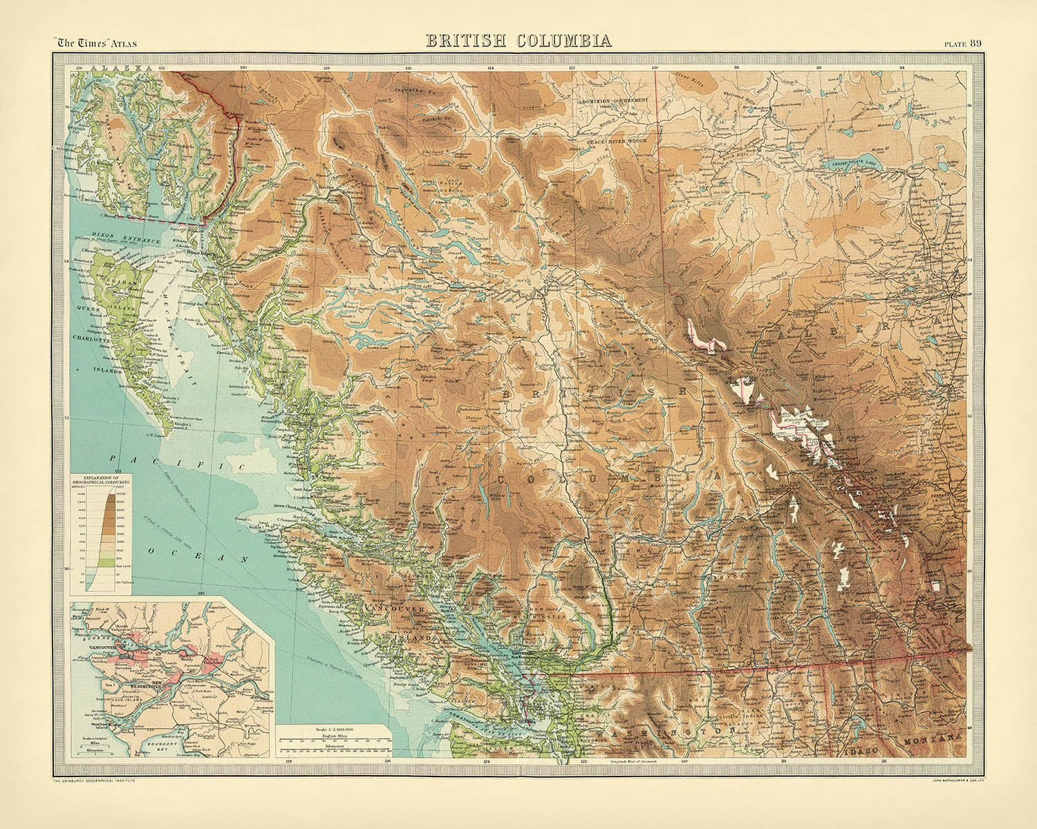
Betreten Sie die geschichtsträchtigen Landschaften der pazifischen Grenze Kanadas mit „British Columbia“, einer 1922 von dem berühmten John George Bartholomew gestalteten Karte....
WeiterlesenBetreten Sie die geschichtsträchtigen Landschaften der pazifischen Grenze Kanadas mit „British Columbia“, einer 1922 von dem berühmten John George Bartholomew gestalteten Karte. Mit ihrem ursprünglichen Titel und einem Punkt – ein eleganter Touch aus der Zeit – steht diese Karte als Zeugnis des goldenen Zeitalters der Kartografie. Beauftragt für die zweite Ausgabe der 1920er Auflage des The Times Atlas & Gazetteer of the World, fängt sie die Provinz in einem entscheidenden Moment ihrer Entwicklung ein, als Eisenbahnen, Ressourcensiedlungen und Naturwunder das Schicksal der Region prägten. Die akribischen Details der Karte laden die Betrachter ein, das weite und vielfältige Terrain von British Columbia zu erkunden, von der rauen Pazifikküste bis zu den schneebedeckten Gipfeln der Rocky Mountains.
Bartholomew, oft als „der Prinz der Kartografen“ gefeiert, brachte ein beispielloses Maß an Kunstfertigkeit und Präzision in dieses Werk ein. Sein innovativer Einsatz von hypsometrischen Farbtönen – subtile Farbverläufe zur Anzeige von Höhenlagen – erweckt das bergige Rückgrat der Provinz zum Leben, während Höhenschichten die Gipfel markieren, die die Skyline definieren. Die bathymetrischen Farbtöne der Karte offenbaren die geheimnisvollen Tiefen des Pazifiks und die komplexen Wasserwege, die durch das Land schneiden, wie die mächtigen Flüsse Fraser und Columbia. Diese visuelle Sprache verbessert nicht nur die Schönheit der Karte, sondern bietet auch ein intuitives Verständnis der dramatischen Topographie British Columbias.
Eine genauere Untersuchung offenbart eine Provinz, die von geografischer und historischer Bedeutung wimmelt. Vancouver Island und die Queen Charlotte Islands (jetzt Haida Gwaii) sind elegant umrissen, während die Regionen Cariboo und Kootenay – Epizentren der Goldrausch- und Bergbau-Booms – von der abenteuerlichen Vergangenheit der Provinz erzählen. Die Karte hebt das labyrinthartige Netzwerk von Seen hervor, darunter Okanagan und Shuswap, sowie die vitalen Handels- und Migrationswege, wie die Canadian Pacific Railway. Jedes Merkmal ist mit der Hingabe eines Kartografen zur Genauigkeit dargestellt, was Bartholomews Engagement für Wissenschaft und Kunst widerspiegelt.
Städte und Gemeinden sind mit einer sorgfältigen Hand markiert, die einen Schnappschuss der städtischen Entwicklung British Columbias bietet. Vancouver, Victoria und New Westminster verankern das aufstrebende städtische Herz der Provinz, während kleinere Siedlungen wie Kamloops, Prince George und Nelson auf die Wellen der Besiedlung und wirtschaftlichen Aktivität hinweisen, die das frühe zwanzigste Jahrhundert prägten. Der Kartenausschnitt des Vancouver-Gebiets, in beeindruckendem Maßstab präsentiert, bietet einen seltenen und detaillierten Einblick in eine Stadt am Rande der modernen Transformation.
Diese Karte ist mehr als ein geografisches Referenzwerk – sie ist ein historisches Artefakt, das den Geist von Erkundung, Unternehmertum und natürlichem Großraum verkörpert, der British Columbia immer definiert hat. Als Teil des Erbes des The Times Atlas markiert sie einen bedeutenden Übergang in der Geschichte der Kartografie, wobei Bartholomews Vision neue Standards für Genauigkeit und ästhetische Anziehungskraft setzt. Für Sammler, Historiker oder einfach für diejenigen, die von den Landschaften des pazifischen Nordwestens verzaubert sind, bietet „British Columbia“ ein Fenster in eine Welt, in der jeder Berg, jeder Fluss und jede Grenze eine Geschichte erzählt.
Städte und Gemeinden auf dieser Karte
- Vancouver
- Surrey
- Burnaby
- Richmond
- Abbotsford
- Coquitlam
- Kelowna
- Nanaimo
- Kamloops
- Victoria
- Chilliwack
- Prince George
- Vernon
- Langley
- Penticton
- Campbell River
- Courtenay
- Powell River
- Nelson
- Cranbrook
- Dawson Creek
- Terrace
- Quesnel
- Williams Lake
- Fort St. John
- Trail
- Kitimat
- Smithers
- Revelstoke
- Fernie
- Golden
- Creston
- Merritt
- Salmon Arm
- Squamish
- Port Alberni
- Parksville
- Sidney
- Kimberley
- Grand Forks
- Castlegar
- Hope
- Lillooet
- Princeton
- Hazelton
- Stewart
- New Westminster
- Esquimalt
- Saanich
- North Vancouver
- West Vancouver
Bemerkenswerte Merkmale & Sehenswürdigkeiten
- Die Rocky Mountains, deutlich dargestellt mit hypsometrischen Farbtönen
- Die Coast Mountains, die parallel zur Pazifikküste verlaufen
- Der Columbia River, ein bedeutendes Flusssystem im Süden von British Columbia
- Der Fraser River, der vom Inland zum Pazifischen Ozean fließt
- Der Okanagan Lake, ein bedeutendes Binnengewässer
- Vancouver Island, dargestellt vor der Südwestküste
- Die Queen Charlotte Islands (jetzt bekannt als Haida Gwaii), beschriftet vor der Nordwestküste
- Die Strait of Georgia, die Vancouver Island vom Festland trennt
- Bathymetrische Schattierungen im Pazifischen Ozean und in großen Seen
- Die Cariboo-Region, historisch bedeutend für den Cariboo-Goldrausch
- Die Kootenay-Region, bekannt für ihr bergiges Terrain und ihre Bergbaugeschichte
- Der Skeena River, ein großer Fluss im Norden von British Columbia
- Der Peace River, der im Nordosten der Provinz fließt
- Wichtige Eisenbahnlinien, einschließlich der Canadian Pacific Railway
- Provinzgrenzen und Landkreis-/Distriktgrenzen deutlich markiert
- Ein Lageplan des Vancouver-Gebiets für mehr Details
- Höhenmarkierungen, die bedeutende Berggipfel kennzeichnen
- Die Alaska-Grenze, die die Grenze zu den Vereinigten Staaten zeigt
- Die südliche Grenze zu den Vereinigten Staaten (Bundesstaat Washington)
- Die Präsenz mehrerer großer Seen, wie dem Shuswap Lake und den Arrow Lakes
Historischer und gestalterischer Kontext
- Erstellt im Jahr 1922 von John George Bartholomew, einem renommierten britischen Kartografen, bekannt für seine innovativen Techniken und Kunstfertigkeit
- Beauftragt für die zweite Ausgabe der 1920er Auflage des Times Atlas & Gazetteer of the World
- Markierte einen bedeutenden Übergang in den kartografischen Quellen, indem sie Karten von Andree aus der Ausgabe von 1895 ersetzte
- Detaillierte politische und physische Karte, die Landkreis- oder Provinzgrenzen, Topografie, Hydrographie und Verkehrswege zeigt
- Verwendet hypsometrische Farbtöne (Farbverläufe nach Höhe) und Höhenmarkierungen zur Darstellung topografischer Variationen
- Bathymetrische Farbtöne wurden verwendet, um die Tiefen von Gewässern darzustellen
- Enthielt eine Seite mit Korrekturen aus der früheren Ausgabe von 1920, die ein Engagement für Genauigkeit und Verfeinerung widerspiegelt
- Veranschaulicht die kartografische Kunst des frühen 20. Jahrhunderts, mit sorgfältiger Beachtung von Farbe, Typografie und geografischer Genauigkeit
- Stellt eine Übergangs- und Fortschrittsperiode in der Atlas-Kartografie dar und ist ein wertvolles Artefakt für Sammler und Historiker
- Die Times Atlas-Serie, die mit dieser Ausgabe begann, hat sich weiterhin als Standardreferenz für die globale Kartografie etabliert
- Betont sowohl die physische Geographie (Berge, Flüsse, Seen) als auch die politischen Grenzen (Landkreise, Bezirke)
- Bemerkenswert für seine detaillierte Darstellung natürlicher Merkmale und der Verkehrsinfrastruktur zu Beginn der 1920er Jahre
Bitte überprüfen Sie die Bilder sorgfältig, um sicherzustellen, dass eine bestimmte Stadt oder ein bestimmter Ort auf dieser Karte angezeigt wird. Sie können uns auch kontaktieren und fragen, ob wir die Karte für Sie überprüfen.
Diese Karte sieht in jeder Größe großartig aus, aber ich empfehle immer, eine größere Größe zu wählen, wenn Sie Platz haben. So können Sie alle Details leicht erkennen.
Diese Karte sieht in Größen bis zu 70 Zoll (180 cm) erstaunlich aus. Wenn Sie nach einer größeren Karte suchen, bitte kontaktieren Sie uns.
Das Modell in den Angebotsbildern hält die 16x20 Zoll (40x50 cm) Version dieser Karte.
Das fünfte Angebotsbild zeigt ein Beispiel für meinen Personalisierungsservice für Karten.
Wenn Sie nach etwas leicht anderem suchen, schauen Sie sich meine Sammlung der besten alten Karten an, um zu sehen, ob etwas anderes Ihr Interesse weckt.
Bitte kontaktieren Sie mich, um zu überprüfen, ob ein bestimmter Ort, ein Wahrzeichen oder ein Merkmal auf dieser Karte angezeigt wird.
Dies wäre ein wunderbares Geschenk zum Geburtstag, zu Weihnachten, zum Vatertag, zum Abschied von der Arbeit, zum Jubiläum oder zur Einweihung für jemanden aus den Gebieten, die von dieser Karte abgedeckt werden.
Diese Karte ist als Giclée-Druck auf säurefreiem, archivfestem mattem Papier erhältlich, oder Sie können sie gerahmt kaufen. Der Rahmen ist ein schöner, einfacher schwarzer Rahmen, der zu den meisten Ästhetiken passt. Bitte kontaktieren Sie mich, wenn Sie eine andere Rahmenfarbe oder -material wünschen. Meine Rahmen sind mit superklarem, museumsglänzendem Acryl (Plexiglas/Acrylit) verglast, das erheblich weniger reflektierend ist als Glas, sicherer und immer in perfektem Zustand ankommt.
This map is also available as a float framed canvas, sometimes known as a shadow gap framed canvas or canvas floater. The map is printed on artist's cotton canvas and then stretched over a handmade box frame. We then "float" the canvas inside a wooden frame, which is available in a range of colours (black, dark brown, oak, antique gold and white). This is a wonderful way to present a map without glazing in front. See some examples of float framed canvas maps and explore the differences between my different finishes.
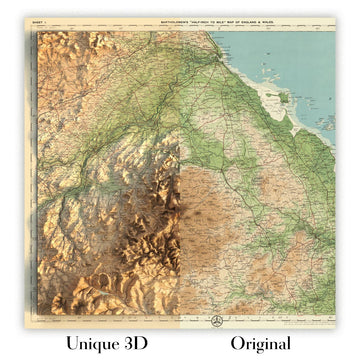
For something truly unique, this map is also available in "Unique 3D", our trademarked process that dramatically transforms the map so that it has a wonderful sense of depth. We combine the original map with detailed topography and elevation data, so that mountains and the terrain really "pop". For more info and examples of 3D maps, check my Unique 3D page.
Betreten Sie die geschichtsträchtigen Landschaften der pazifischen Grenze Kanadas mit „British Columbia“, einer 1922 von dem berühmten John George Bartholomew gestalteten Karte. Mit ihrem ursprünglichen Titel und einem Punkt – ein eleganter Touch aus der Zeit – steht diese Karte als Zeugnis des goldenen Zeitalters der Kartografie. Beauftragt für die zweite Ausgabe der 1920er Auflage des The Times Atlas & Gazetteer of the World, fängt sie die Provinz in einem entscheidenden Moment ihrer Entwicklung ein, als Eisenbahnen, Ressourcensiedlungen und Naturwunder das Schicksal der Region prägten. Die akribischen Details der Karte laden die Betrachter ein, das weite und vielfältige Terrain von British Columbia zu erkunden, von der rauen Pazifikküste bis zu den schneebedeckten Gipfeln der Rocky Mountains.
Bartholomew, oft als „der Prinz der Kartografen“ gefeiert, brachte ein beispielloses Maß an Kunstfertigkeit und Präzision in dieses Werk ein. Sein innovativer Einsatz von hypsometrischen Farbtönen – subtile Farbverläufe zur Anzeige von Höhenlagen – erweckt das bergige Rückgrat der Provinz zum Leben, während Höhenschichten die Gipfel markieren, die die Skyline definieren. Die bathymetrischen Farbtöne der Karte offenbaren die geheimnisvollen Tiefen des Pazifiks und die komplexen Wasserwege, die durch das Land schneiden, wie die mächtigen Flüsse Fraser und Columbia. Diese visuelle Sprache verbessert nicht nur die Schönheit der Karte, sondern bietet auch ein intuitives Verständnis der dramatischen Topographie British Columbias.
Eine genauere Untersuchung offenbart eine Provinz, die von geografischer und historischer Bedeutung wimmelt. Vancouver Island und die Queen Charlotte Islands (jetzt Haida Gwaii) sind elegant umrissen, während die Regionen Cariboo und Kootenay – Epizentren der Goldrausch- und Bergbau-Booms – von der abenteuerlichen Vergangenheit der Provinz erzählen. Die Karte hebt das labyrinthartige Netzwerk von Seen hervor, darunter Okanagan und Shuswap, sowie die vitalen Handels- und Migrationswege, wie die Canadian Pacific Railway. Jedes Merkmal ist mit der Hingabe eines Kartografen zur Genauigkeit dargestellt, was Bartholomews Engagement für Wissenschaft und Kunst widerspiegelt.
Städte und Gemeinden sind mit einer sorgfältigen Hand markiert, die einen Schnappschuss der städtischen Entwicklung British Columbias bietet. Vancouver, Victoria und New Westminster verankern das aufstrebende städtische Herz der Provinz, während kleinere Siedlungen wie Kamloops, Prince George und Nelson auf die Wellen der Besiedlung und wirtschaftlichen Aktivität hinweisen, die das frühe zwanzigste Jahrhundert prägten. Der Kartenausschnitt des Vancouver-Gebiets, in beeindruckendem Maßstab präsentiert, bietet einen seltenen und detaillierten Einblick in eine Stadt am Rande der modernen Transformation.
Diese Karte ist mehr als ein geografisches Referenzwerk – sie ist ein historisches Artefakt, das den Geist von Erkundung, Unternehmertum und natürlichem Großraum verkörpert, der British Columbia immer definiert hat. Als Teil des Erbes des The Times Atlas markiert sie einen bedeutenden Übergang in der Geschichte der Kartografie, wobei Bartholomews Vision neue Standards für Genauigkeit und ästhetische Anziehungskraft setzt. Für Sammler, Historiker oder einfach für diejenigen, die von den Landschaften des pazifischen Nordwestens verzaubert sind, bietet „British Columbia“ ein Fenster in eine Welt, in der jeder Berg, jeder Fluss und jede Grenze eine Geschichte erzählt.
Städte und Gemeinden auf dieser Karte
- Vancouver
- Surrey
- Burnaby
- Richmond
- Abbotsford
- Coquitlam
- Kelowna
- Nanaimo
- Kamloops
- Victoria
- Chilliwack
- Prince George
- Vernon
- Langley
- Penticton
- Campbell River
- Courtenay
- Powell River
- Nelson
- Cranbrook
- Dawson Creek
- Terrace
- Quesnel
- Williams Lake
- Fort St. John
- Trail
- Kitimat
- Smithers
- Revelstoke
- Fernie
- Golden
- Creston
- Merritt
- Salmon Arm
- Squamish
- Port Alberni
- Parksville
- Sidney
- Kimberley
- Grand Forks
- Castlegar
- Hope
- Lillooet
- Princeton
- Hazelton
- Stewart
- New Westminster
- Esquimalt
- Saanich
- North Vancouver
- West Vancouver
Bemerkenswerte Merkmale & Sehenswürdigkeiten
- Die Rocky Mountains, deutlich dargestellt mit hypsometrischen Farbtönen
- Die Coast Mountains, die parallel zur Pazifikküste verlaufen
- Der Columbia River, ein bedeutendes Flusssystem im Süden von British Columbia
- Der Fraser River, der vom Inland zum Pazifischen Ozean fließt
- Der Okanagan Lake, ein bedeutendes Binnengewässer
- Vancouver Island, dargestellt vor der Südwestküste
- Die Queen Charlotte Islands (jetzt bekannt als Haida Gwaii), beschriftet vor der Nordwestküste
- Die Strait of Georgia, die Vancouver Island vom Festland trennt
- Bathymetrische Schattierungen im Pazifischen Ozean und in großen Seen
- Die Cariboo-Region, historisch bedeutend für den Cariboo-Goldrausch
- Die Kootenay-Region, bekannt für ihr bergiges Terrain und ihre Bergbaugeschichte
- Der Skeena River, ein großer Fluss im Norden von British Columbia
- Der Peace River, der im Nordosten der Provinz fließt
- Wichtige Eisenbahnlinien, einschließlich der Canadian Pacific Railway
- Provinzgrenzen und Landkreis-/Distriktgrenzen deutlich markiert
- Ein Lageplan des Vancouver-Gebiets für mehr Details
- Höhenmarkierungen, die bedeutende Berggipfel kennzeichnen
- Die Alaska-Grenze, die die Grenze zu den Vereinigten Staaten zeigt
- Die südliche Grenze zu den Vereinigten Staaten (Bundesstaat Washington)
- Die Präsenz mehrerer großer Seen, wie dem Shuswap Lake und den Arrow Lakes
Historischer und gestalterischer Kontext
- Erstellt im Jahr 1922 von John George Bartholomew, einem renommierten britischen Kartografen, bekannt für seine innovativen Techniken und Kunstfertigkeit
- Beauftragt für die zweite Ausgabe der 1920er Auflage des Times Atlas & Gazetteer of the World
- Markierte einen bedeutenden Übergang in den kartografischen Quellen, indem sie Karten von Andree aus der Ausgabe von 1895 ersetzte
- Detaillierte politische und physische Karte, die Landkreis- oder Provinzgrenzen, Topografie, Hydrographie und Verkehrswege zeigt
- Verwendet hypsometrische Farbtöne (Farbverläufe nach Höhe) und Höhenmarkierungen zur Darstellung topografischer Variationen
- Bathymetrische Farbtöne wurden verwendet, um die Tiefen von Gewässern darzustellen
- Enthielt eine Seite mit Korrekturen aus der früheren Ausgabe von 1920, die ein Engagement für Genauigkeit und Verfeinerung widerspiegelt
- Veranschaulicht die kartografische Kunst des frühen 20. Jahrhunderts, mit sorgfältiger Beachtung von Farbe, Typografie und geografischer Genauigkeit
- Stellt eine Übergangs- und Fortschrittsperiode in der Atlas-Kartografie dar und ist ein wertvolles Artefakt für Sammler und Historiker
- Die Times Atlas-Serie, die mit dieser Ausgabe begann, hat sich weiterhin als Standardreferenz für die globale Kartografie etabliert
- Betont sowohl die physische Geographie (Berge, Flüsse, Seen) als auch die politischen Grenzen (Landkreise, Bezirke)
- Bemerkenswert für seine detaillierte Darstellung natürlicher Merkmale und der Verkehrsinfrastruktur zu Beginn der 1920er Jahre
Bitte überprüfen Sie die Bilder sorgfältig, um sicherzustellen, dass eine bestimmte Stadt oder ein bestimmter Ort auf dieser Karte angezeigt wird. Sie können uns auch kontaktieren und fragen, ob wir die Karte für Sie überprüfen.
Diese Karte sieht in jeder Größe großartig aus, aber ich empfehle immer, eine größere Größe zu wählen, wenn Sie Platz haben. So können Sie alle Details leicht erkennen.
Diese Karte sieht in Größen bis zu 70 Zoll (180 cm) erstaunlich aus. Wenn Sie nach einer größeren Karte suchen, bitte kontaktieren Sie uns.
Das Modell in den Angebotsbildern hält die 16x20 Zoll (40x50 cm) Version dieser Karte.
Das fünfte Angebotsbild zeigt ein Beispiel für meinen Personalisierungsservice für Karten.
Wenn Sie nach etwas leicht anderem suchen, schauen Sie sich meine Sammlung der besten alten Karten an, um zu sehen, ob etwas anderes Ihr Interesse weckt.
Bitte kontaktieren Sie mich, um zu überprüfen, ob ein bestimmter Ort, ein Wahrzeichen oder ein Merkmal auf dieser Karte angezeigt wird.
Dies wäre ein wunderbares Geschenk zum Geburtstag, zu Weihnachten, zum Vatertag, zum Abschied von der Arbeit, zum Jubiläum oder zur Einweihung für jemanden aus den Gebieten, die von dieser Karte abgedeckt werden.
Diese Karte ist als Giclée-Druck auf säurefreiem, archivfestem mattem Papier erhältlich, oder Sie können sie gerahmt kaufen. Der Rahmen ist ein schöner, einfacher schwarzer Rahmen, der zu den meisten Ästhetiken passt. Bitte kontaktieren Sie mich, wenn Sie eine andere Rahmenfarbe oder -material wünschen. Meine Rahmen sind mit superklarem, museumsglänzendem Acryl (Plexiglas/Acrylit) verglast, das erheblich weniger reflektierend ist als Glas, sicherer und immer in perfektem Zustand ankommt.
This map is also available as a float framed canvas, sometimes known as a shadow gap framed canvas or canvas floater. The map is printed on artist's cotton canvas and then stretched over a handmade box frame. We then "float" the canvas inside a wooden frame, which is available in a range of colours (black, dark brown, oak, antique gold and white). This is a wonderful way to present a map without glazing in front. See some examples of float framed canvas maps and explore the differences between my different finishes.
For something truly unique, this map is also available in "Unique 3D", our trademarked process that dramatically transforms the map so that it has a wonderful sense of depth. We combine the original map with detailed topography and elevation data, so that mountains and the terrain really "pop". For more info and examples of 3D maps, check my Unique 3D page.
Many of our maps and art prints are chosen as thoughtful gifts for homes, offices, studies and meaningful places.
Choose a framed option for the easiest ready-to-hang gift, or choose an unframed print if the recipient may prefer to select their own frame.
We make orders locally in 23 countries around the world, so gifts can often be produced close to the recipient. This helps them arrive faster, travel more safely, and avoid customs or import duty surprises.
- We can deliver directly to the recipient
- Framed pieces arrive ready to hang
- Unframed prints are carefully packed in a strong protective tube
- Almost every order is made locally, for faster, safer gifting
- 90-day returns give the recipient time to decide
If you are not sure what to choose, please contact us. We can help you pick the right map, size, finish or delivery option.
Für die meisten Bestellungen beträgt die Lieferzeit etwa 3 Werktage. Personalisierte und maßgeschneiderte Produkte benötigen länger, da ich die Personalisierung durchführen und sie Ihnen zur Genehmigung zusenden muss, was normalerweise 1 oder 2 Tage dauert.
Bitte beachten Sie, dass sehr große gerahmte Bestellungen in der Regel länger für die Herstellung und Lieferung benötigen.
Wenn Sie möchten, dass Ihre Bestellung bis zu einem bestimmten Datum ankommt, bitte kontaktieren Sie mich, bevor Sie bestellen, damit wir den besten Weg finden können, um sicherzustellen, dass Sie Ihre Bestellung rechtzeitig erhalten.
Ich drucke und rahme Karten und Kunstwerke in 23 Ländern weltweit. Das bedeutet, dass Ihre Bestellung lokal gefertigt wird, was die Lieferzeit verkürzt und sicherstellt, dass sie während der Lieferung nicht beschädigt wird. Sie zahlen nie Zoll oder Einfuhrgebühren, und wir stoßen weniger CO2 in die Luft aus.
Alle meine Karten und Kunstdrucke sind gut verpackt und werden in einem robusten Rohr versendet, wenn sie ungerahmt sind, oder von Schaum umgeben, wenn sie gerahmt sind.
Ich versuche, alle Bestellungen innerhalb von 1 oder 2 Tagen nach Erhalt Ihrer Bestellung zu versenden, obwohl einige Produkte (wie Gesichtsmasken, Tassen und Tragetaschen) länger zur Herstellung benötigen können.
Wenn Sie Express-Lieferung an der Kasse auswählen, priorisieren wir Ihre Bestellung und versenden sie per 1-Tages-Kurier (Fedex, DHL, UPS, Parcelforce).
Nächster Tag Lieferung ist auch in einigen Ländern verfügbar (USA, UK, Singapur, VAE), aber bitte versuchen Sie, früh am Tag zu bestellen, damit wir es rechtzeitig versenden können.
Lesen Sie meinen vollständigen Leitfaden zur Lieferung und lokalen Produktion
Mein Standardrahmen ist ein Galerie-Stil-Rahmen aus schwarzem Eschenholz. Er ist einfach und sieht ziemlich modern aus. Mein Standardrahmen ist etwa 20 mm (0,8 Zoll) breit.
Ich verwende super-klares Acryl (Plexiglas/Acrylt) für das Glas des Rahmens. Es ist leichter und sicherer als Glas – und es sieht besser aus, da die Reflexion geringer ist.
Sechs Standardrahmenfarben sind kostenlos erhältlich (schwarz, dunkelbraun, dunkelgrau, Eiche, weiß und antikgold).
Die meisten Karten, Kunstwerke und Illustrationen sind auch als gerahmte Leinwand erhältlich. Wir verwenden matte (nicht glänzende) Baumwollleinwand, spannen sie über einen nachhaltig beschafften Buchenrahmen und 'schweben' dann das Stück innerhalb eines Holzrahmens. Das Endergebnis ist ziemlich schön, und es gibt keine Verglasung, die im Weg ist.
Alle Rahmen werden "bereit zum Aufhängen" geliefert, entweder mit einer Schnur oder Halterungen auf der Rückseite. Sehr große Rahmen haben schwere Aufhängeplatten und/oder eine Montageschiene. Wenn Sie Fragen haben, können Sie bitte Kontakt aufnehmen.
Sehen Sie sich einige Beispiele meiner gerahmten Karten und gerahmten Leinwandkarten an.
Alternativ kann ich auch alte Karten und Kunstwerke auf Leinwand, Schaumstoffplatten, Baumwollrag und andere Materialien liefern.
Wenn Sie Ihre Karte oder Ihr Kunstwerk selbst rahmen möchten, lesen Sie bitte zuerst meinen Größenleitfaden.
Meine Karten sind äußerst hochwertige Reproduktionen von Originalkarten.
Ich beziehe originale, seltene Karten aus Bibliotheken, Auktionshäusern und Privatsammlungen auf der ganzen Welt, restauriere sie in meiner Londoner Werkstatt und erstelle dann mit speziellen Giclée-Tinten und -Druckern wunderschöne Karten, die sogar noch besser aussehen als das Original.
Meine Karten werden auf säurefreiem, mattem Archivpapier (nicht glänzend) gedruckt, das sich sehr hochwertig anfühlt und fast wie Karton aussieht. Technisch gesehen beträgt das Papiergewicht/die Papierdicke 10mil/200g/m². Es eignet sich perfekt zum Einrahmen.
Ich drucke mit UV-lichtbeständigen Ultrachrome-Giclée-Pigmenttinten von Epson – einige der besten Tinten, die Sie finden können.
Ich kann auch machen Karten auf Leinwand, Baumwolllappen und andere exotische Materialien.
Erfahren Sie mehr über The Unique Maps Co.
Kartenpersonalisierung
Wenn Sie nach dem perfekten Geschenk zum Jahrestag oder zur Einweihung suchen, kann ich Ihre Karte personalisieren, um sie wirklich einzigartig zu machen. Ich kann beispielsweise eine kurze Nachricht hinzufügen, einen wichtigen Ort hervorheben oder das Wappen Ihrer Familie hinzufügen.
Die Möglichkeiten sind nahezu unbegrenzt. Bitte sehen Sie sich meine Kartenpersonalisierungsseite für einige wunderbare Beispiele dessen, was möglich ist.
Um eine personalisierte Karte zu bestellen, wählen Sie „Personalisieren Sie Ihre Karte“, bevor Sie sie in den Warenkorb legen.
In Kontakt kommen wenn Sie nach komplexeren Anpassungen und Personalisierungen suchen.
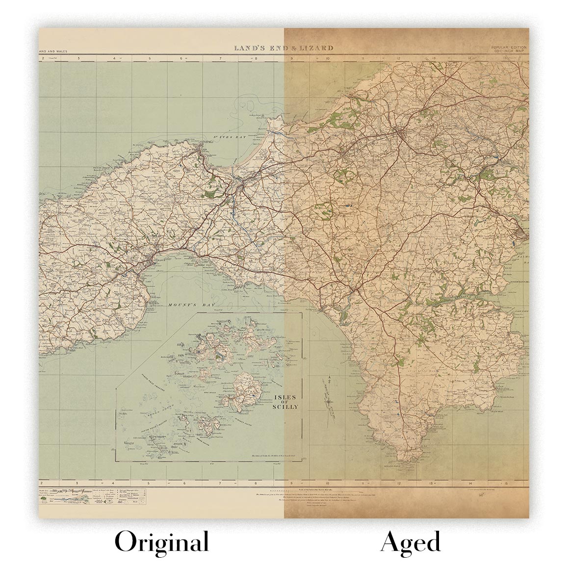
Kartenalterung
Im Laufe der Jahre wurde ich von Kunden hunderte Male gefragt, ob sie eine Karte kaufen könnten, die noch älter.
Nun, jetzt können Sie das, indem Sie „Alter“ auswählen, bevor Sie eine Karte in Ihren Warenkorb legen.
Alle Produktfotos, die Sie auf dieser Seite sehen, zeigen die Karte in ihrer Originalform. So sieht die Karte heute aus.
Wenn Sie „Gealtert“ auswählen, werde ich Ihre Karte von Hand altern lassen. Dazu verwende ich ein spezielles und einzigartiges Verfahren, das ich durch jahrelanges Studium alter Karten und Gespräche mit Forschern zum Verständnis der Chemie alternder Papiere entwickelt habe, und natürlich ... viel Übung!
Wenn Sie sich nicht sicher sind, bleiben Sie bei der Originalfarbe der Karte. Wenn Sie etwas Dunkleres und älter Wenn Sie auf der Suche sind, entscheiden Sie sich für „Aged“.
Sehen Sie einige erstaunliche Beispiele für gealterte Karten.
Wenn Sie aus irgendeinem Grund mit Ihrer Bestellung nicht zufrieden sind, kontaktieren Sie mich für eine unkomplizierte Rückerstattung. Bitte sehen Sie sich unsere Rückgabe- und Rückerstattungsrichtlinien für weitere Informationen an.
Ich bin sehr zuversichtlich, dass Ihnen Ihre restaurierte Karte oder Kunstdruck gefallen wird. Ich mache das seit 1984. Ich bin ein 5-Sterne Etsy-Verkäufer. Ich habe Zehntausende von Karten und Kunstdrucken verkauft und habe über 5.000 echte 5-Sterne-Bewertungen.
Ich verwende einen einzigartigen Prozess, um Karten und Kunstwerke zu restaurieren, der extrem zeitaufwendig und arbeitsintensiv ist. Die Suche nach den Originalkarten und Illustrationen kann Monate dauern. Ich benutze modernste und unglaublich teure Technologie, um sie zu scannen und wiederherzustellen. Daher garantiere ich, dass meine Karten und Kunstdrucke eine Klasse für sich sind - deshalb kann ich eine unkomplizierte Rückerstattung anbieten.
Fast alle meine Karten und Kunstdrucke sehen in großen Größen (200 cm, 6,5 Fuß+) erstaunlich aus und ich kann sie Ihnen auch gerahmt und über einen speziellen Übergrößen-Kurier liefern. Kontaktieren Sie mich, um Ihre speziellen Bedürfnisse zu besprechen.
Or try searching for something!


