

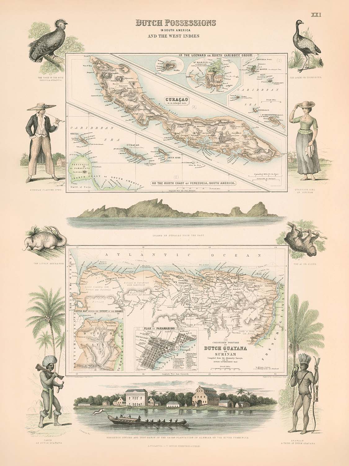


Alte Karte von Curaçao, Suriname und den Leeward-Inseln von Fullarton, 1865: Koloniale niederländische Besitztümer
Das Sammlerangebot
Wählen Sie zwei berechtigte Werke und erhalten Sie auf beide 20 % Rabatt. Wählen Sie drei, und das günstigste ist kostenlos – eine maximale Ersparnis von 33 %.
Kombinieren Sie berechtigte Standardkarten und Kunstdrucke nach Belieben. Kein Code erforderlich; das Angebot wird an der Kasse automatisch angewendet.
Standardmäßige Konfigurationen nach Maßanfertigung sind inbegriffen. Maßgeschneiderte Größen, personalisierte Entwürfe und Auftragsarbeiten sind ausgeschlossen.
Benötigen Sie die Lieferung an unterschiedliche Adressen? Kontaktieren Sie uns vor der Bestellung.Das Sammlerangebot
Wählen Sie zwei berechtigte Werke und erhalten Sie auf beide 20 % Rabatt. Wählen Sie drei, und das günstigste ist kostenlos – eine maximale Ersparnis von 33 %.
Kombinieren Sie berechtigte Standardkarten und Kunstdrucke nach Belieben. Kein Code erforderlich; das Angebot wird an der Kasse automatisch angewendet.
Standardmäßige Konfigurationen nach Maßanfertigung sind inbegriffen. Maßgeschneiderte Größen, personalisierte Entwürfe und Auftragsarbeiten sind ausgeschlossen.
Benötigen Sie die Lieferung an unterschiedliche Adressen? Kontaktieren Sie uns vor der Bestellung. In London restauriert • Hergestellt in the USA

Aus der Originalkarte von 1865 restauriert und in Museumsqualität gedruckt. Die Geschichte hinter dieser Karte lesen
Choose your size
Choose your finish


(Mehr Infos)
Geschenkmitteilung & individuelle Ausführung

Wenn Sie eine Geschenkmitteilung oder eine Ausführung (Puzzle, Aluminiumplatte usw.) hinzufügen möchten, die hier nicht verfügbar ist, geben Sie dies bitte in der "Bestellnotiz" beim Checkout an.
Jede Bestellung wird individuell angefertigt. Wenn Sie die Größe leicht anpassen oder auf einem ungewöhnlichen Material drucken lassen möchten, lassen Sie es uns einfach wissen. Wir haben im Laufe der Jahre Tausende von individuellen Bestellungen bearbeitet, daher gibt es (fast) nichts, was wir nicht bewältigen können.
Sie können uns auch kontaktieren, bevor Sie bestellen, wenn Sie möchten!

- Lokal gefertigt. Sicher geliefert
- Keine Zölle oder versteckten Gebühren
- Hilfe nötig? Rufen Sie uns an oder WhatsApp schreiben
Own a piece of history
8,000+ five-star reviews


Betreten Sie die komplexe Welt der kolonialen Kartografie des 19. Jahrhunderts mit dieser exquisiten Karte, die ursprünglich den Titel "(Curacao, Leeward Islands,...
WeiterlesenBetreten Sie die komplexe Welt der kolonialen Kartografie des 19. Jahrhunderts mit dieser exquisiten Karte, die ursprünglich den Titel "(Curacao, Leeward Islands, Guyana) Niederländische Besitztümer in Südamerika und den Westindischen Inseln" trug. Sie wurde 1865 vom angesehenen schottischen Verlag Archibald Fullarton & Co. erstellt und bietet einen Einblick in den niederländischen Kolonialbereich zur Blütezeit seines Einflusses in der Karibik und Südamerika. Das elegante Design der Karte wird durch fein detaillierte politische Grenzen und eine sorgfältige Darstellung der vielfältigen Geographie der Region ergänzt, was sie sowohl zu einem Kunstwerk als auch zu einem historischen Dokument seltener Bedeutung macht.
Archibald Fullarton & Co. war bekannt für ihr Engagement für Präzision und Kunstfertigkeit in der Kartografie, und dieses Stück ist ein Zeugnis ihres Erbes. Die Liebe zum Detail des Verlegers zeigt sich in den dekorativen Verzierungen der Karte und in der Einbeziehung aufwendiger Illustrationen. Besonders bemerkenswert ist die große, eindrucksvolle Ansicht der Residenzbüros und Tent-Barte der Kakaoplantagen von Alkmaar am Fluss Commewina sowie eine malerische Aussicht auf Curaçao aus östlicher Richtung. Diese Vignetten bieten nicht nur visuelle Freude, sondern auch eine greifbare Verbindung zu den wirtschaftlichen und architektonischen Realitäten des niederländischen Kolonialunternehmens.
Der Umfang der Karte umfasst die wichtigsten niederländischen Besitztümer der Epoche: Curaçao, die Leeward Islands und Surinam (niederländisches Guayana). Diese Regionen sind präzise dargestellt, ihre Küstenlinien und Flüsse sorgfältig kartiert. Die Karibische See und der Atlantische Ozean rahmen die Territorien ein, während der Fluss Commewina sich durch Surinam schlängelt und die Bedeutung der Wasserwege im kolonialen Handel und in der Landwirtschaft unterstreicht. Die Grenzen der Karte sind klar abgegrenzt und spiegeln die komplexe geopolitische Landschaft der Karibik und Südamerikas im 19. Jahrhundert wider.
Innerhalb dieser Regionen hebt die Karte bedeutende urbane Zentren hervor, die bis heute von Bedeutung sind. Willemstad, die lebendige Hauptstadt von Curaçao, wird prominent dargestellt, ihre historische Bedeutung als Handelszentrum ist unmissverständlich. In Surinam sticht Paramaribo als das Herz des niederländischen Guayana hervor, eine Stadt, deren koloniale Vergangenheit in ihrer Architektur und ihrem städtischen Gefüge noch sichtbar ist. Diese Siedlungen, klar markiert, laden den Betrachter ein, sich das geschäftige Leben und den Handel vorzustellen, die einst diese kolonialen Außenposten belebt haben.
Über die geografischen und politischen Details hinaus bietet diese Karte einen einzigartigen Einblick in die wirtschaftlichen Prioritäten und die natürliche Schönheit der Epoche. Die Einbeziehung der Illustration der Kakaoplantage von Alkmaar spricht von der Zentralität der Landwirtschaft - insbesondere des Kakaos - in der niederländischen Kolonialwirtschaft. Die üppigen Ufer, weitläufigen Küstenlinien und strategischen Häfen, die hier dargestellt sind, erzählen eine Geschichte von Erkundung, Ausbeutung und bleibendem Erbe. Diese Karte ist nicht nur ein Schatz für Sammler, sondern auch eine greifbare Erzählung einer Welt, die von Ehrgeiz, Kunstfertigkeit und dem unermüdlichen Streben nach Entdeckung geprägt ist.
Städte und Orte auf dieser Karte
- Curaçao (das heutige Curaçao):
- Willemstad
- Surinam (das heutige Suriname):
- Paramaribo
Bemerkenswerte Merkmale & Wahrzeichen
- Große Illustration der Residenzbüros und Tent-Barte der Kakaoplantagen von Alkmaar am Fluss Commewina
- Ansicht von Curaçao aus östlicher Richtung, die die Küstengeographie und koloniale Architektur zeigt
- Karibische See
- Atlantischer Ozean
- Fluss Commewina (Surinam)
- Deutlich markierte koloniale Grenzen der niederländischen Besitztümer
- Alkmaar Kakaoplantage (Surinam), prominent illustriert und beschriftet
- Küstenlinien, Flüsse und allgemeine Topographie klar dargestellt
Historischer und gestalterischer Kontext
- Erstellt 1865 von Archibald Fullarton & Co., einem angesehenen schottischen Verlag, der für detaillierte und dekorative Karten bekannt ist
- Dekorative Karte, die Curaçao, die Leeward-Inseln und Surinam (niederländisches Guayana) zeigt
- Kombiniert politische Grenzen, physische Geographie und wirtschaftliche Aktivitäten wie Kakaoplantagen
- Spiegelt den niederländischen kolonialen Einfluss in der Karibik und Südamerika im 19. Jahrhundert wider
- Künstlerische Illustrationen bieten historischen Kontext zu wirtschaftlichen Aktivitäten und kolonialer Architektur
- Veranschaulicht den kartografischen Stil der Mitte des 19. Jahrhunderts, der geografische Genauigkeit mit künstlerischen Verzierungen verbindet
Bitte überprüfen Sie die Bilder, um sicherzustellen, dass eine bestimmte Stadt oder ein Ort auf dieser Karte dargestellt ist. Sie können auch Kontakt aufnehmen und uns bitten, die Karte für Sie zu überprüfen.
Diese Karte sieht in jeder Größe großartig aus, aber ich empfehle immer, eine größere Größe zu wählen, wenn Sie Platz haben. So können Sie alle Details leicht erkennen.
Diese Karte sieht bis zu 70 Zoll (180 cm) großartig aus. Wenn Sie nach einer größeren Karte suchen, bitte nehmen Sie Kontakt auf.
Bitte beachten Sie: Die Beschriftungen auf dieser Karte sind schwer zu lesen, wenn Sie eine Karte bestellen, die 16 Zoll (40 cm) oder kleiner ist. Die Karte ist immer noch sehr attraktiv, aber wenn Sie die Karte leicht lesen möchten, kaufen Sie bitte eine größere Größe.
Das Modell in den Angebotsbildern hält die 18x24 Zoll (45x60 cm) Version dieser Karte.
Das fünfte Angebotsbild zeigt ein Beispiel meines Personalisierungsservices für Karten.
Wenn Sie nach etwas leicht anderem suchen, schauen Sie sich meine Sammlung der besten alten Karten an, um zu sehen, ob Ihnen etwas anderes ins Auge fällt.
Bitte kontaktieren Sie mich, um zu überprüfen, ob ein bestimmter Standort, Wahrzeichen oder Merkmal auf dieser Karte dargestellt ist.
Dies wäre ein wunderbares Geburtstags-, Weihnachts-, Vatertags-, Abschiedsgeschenk, Jubiläum oder Einweihungsgeschenk für jemanden aus den in dieser Karte abgedeckten Gebieten.
Diese Karte ist als Giclée-Druck auf säurefreiem, archivierbarem mattem Papier erhältlich, oder Sie können sie gerahmt kaufen. Der Rahmen ist ein schöner, einfacher schwarzer Rahmen, der zu den meisten Ästhetiken passt. Bitte nehmen Sie Kontakt auf, wenn Sie eine andere Rahmenfarbe oder -material wünschen. Meine Rahmen sind mit superklarem museumsglasähnlichem Acryl (Plexiglas/Acrylt) verglast, das deutlich weniger reflektierend ist als Glas, sicherer ist und immer in perfektem Zustand ankommt.
This map is also available as a float framed canvas, sometimes known as a shadow gap framed canvas or canvas floater. The map is printed on artist's cotton canvas and then stretched over a handmade box frame. We then "float" the canvas inside a wooden frame, which is available in a range of colours (black, dark brown, oak, antique gold and white). This is a wonderful way to present a map without glazing in front. See some examples of float framed canvas maps and explore the differences between my different finishes.
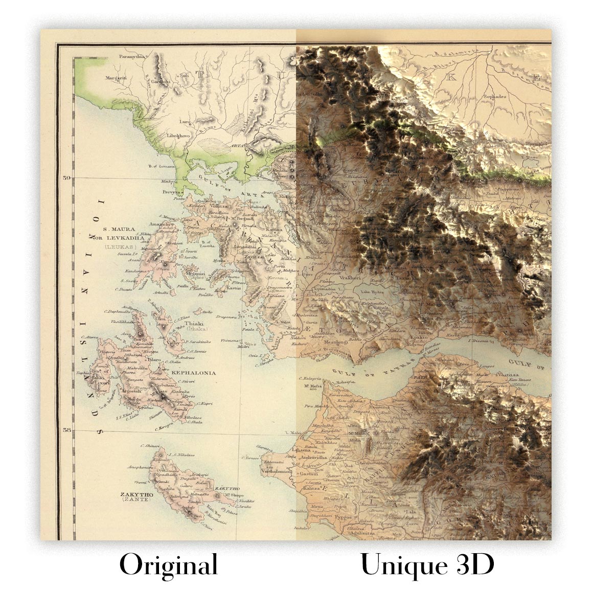
For something truly unique, this map is also available in "Unique 3D", our trademarked process that dramatically transforms the map so that it has a wonderful sense of depth. We combine the original map with detailed topography and elevation data, so that mountains and the terrain really "pop". For more info and examples of 3D maps, check my Unique 3D page.
Betreten Sie die komplexe Welt der kolonialen Kartografie des 19. Jahrhunderts mit dieser exquisiten Karte, die ursprünglich den Titel "(Curacao, Leeward Islands, Guyana) Niederländische Besitztümer in Südamerika und den Westindischen Inseln" trug. Sie wurde 1865 vom angesehenen schottischen Verlag Archibald Fullarton & Co. erstellt und bietet einen Einblick in den niederländischen Kolonialbereich zur Blütezeit seines Einflusses in der Karibik und Südamerika. Das elegante Design der Karte wird durch fein detaillierte politische Grenzen und eine sorgfältige Darstellung der vielfältigen Geographie der Region ergänzt, was sie sowohl zu einem Kunstwerk als auch zu einem historischen Dokument seltener Bedeutung macht.
Archibald Fullarton & Co. war bekannt für ihr Engagement für Präzision und Kunstfertigkeit in der Kartografie, und dieses Stück ist ein Zeugnis ihres Erbes. Die Liebe zum Detail des Verlegers zeigt sich in den dekorativen Verzierungen der Karte und in der Einbeziehung aufwendiger Illustrationen. Besonders bemerkenswert ist die große, eindrucksvolle Ansicht der Residenzbüros und Tent-Barte der Kakaoplantagen von Alkmaar am Fluss Commewina sowie eine malerische Aussicht auf Curaçao aus östlicher Richtung. Diese Vignetten bieten nicht nur visuelle Freude, sondern auch eine greifbare Verbindung zu den wirtschaftlichen und architektonischen Realitäten des niederländischen Kolonialunternehmens.
Der Umfang der Karte umfasst die wichtigsten niederländischen Besitztümer der Epoche: Curaçao, die Leeward Islands und Surinam (niederländisches Guayana). Diese Regionen sind präzise dargestellt, ihre Küstenlinien und Flüsse sorgfältig kartiert. Die Karibische See und der Atlantische Ozean rahmen die Territorien ein, während der Fluss Commewina sich durch Surinam schlängelt und die Bedeutung der Wasserwege im kolonialen Handel und in der Landwirtschaft unterstreicht. Die Grenzen der Karte sind klar abgegrenzt und spiegeln die komplexe geopolitische Landschaft der Karibik und Südamerikas im 19. Jahrhundert wider.
Innerhalb dieser Regionen hebt die Karte bedeutende urbane Zentren hervor, die bis heute von Bedeutung sind. Willemstad, die lebendige Hauptstadt von Curaçao, wird prominent dargestellt, ihre historische Bedeutung als Handelszentrum ist unmissverständlich. In Surinam sticht Paramaribo als das Herz des niederländischen Guayana hervor, eine Stadt, deren koloniale Vergangenheit in ihrer Architektur und ihrem städtischen Gefüge noch sichtbar ist. Diese Siedlungen, klar markiert, laden den Betrachter ein, sich das geschäftige Leben und den Handel vorzustellen, die einst diese kolonialen Außenposten belebt haben.
Über die geografischen und politischen Details hinaus bietet diese Karte einen einzigartigen Einblick in die wirtschaftlichen Prioritäten und die natürliche Schönheit der Epoche. Die Einbeziehung der Illustration der Kakaoplantage von Alkmaar spricht von der Zentralität der Landwirtschaft - insbesondere des Kakaos - in der niederländischen Kolonialwirtschaft. Die üppigen Ufer, weitläufigen Küstenlinien und strategischen Häfen, die hier dargestellt sind, erzählen eine Geschichte von Erkundung, Ausbeutung und bleibendem Erbe. Diese Karte ist nicht nur ein Schatz für Sammler, sondern auch eine greifbare Erzählung einer Welt, die von Ehrgeiz, Kunstfertigkeit und dem unermüdlichen Streben nach Entdeckung geprägt ist.
Städte und Orte auf dieser Karte
- Curaçao (das heutige Curaçao):
- Willemstad
- Surinam (das heutige Suriname):
- Paramaribo
Bemerkenswerte Merkmale & Wahrzeichen
- Große Illustration der Residenzbüros und Tent-Barte der Kakaoplantagen von Alkmaar am Fluss Commewina
- Ansicht von Curaçao aus östlicher Richtung, die die Küstengeographie und koloniale Architektur zeigt
- Karibische See
- Atlantischer Ozean
- Fluss Commewina (Surinam)
- Deutlich markierte koloniale Grenzen der niederländischen Besitztümer
- Alkmaar Kakaoplantage (Surinam), prominent illustriert und beschriftet
- Küstenlinien, Flüsse und allgemeine Topographie klar dargestellt
Historischer und gestalterischer Kontext
- Erstellt 1865 von Archibald Fullarton & Co., einem angesehenen schottischen Verlag, der für detaillierte und dekorative Karten bekannt ist
- Dekorative Karte, die Curaçao, die Leeward-Inseln und Surinam (niederländisches Guayana) zeigt
- Kombiniert politische Grenzen, physische Geographie und wirtschaftliche Aktivitäten wie Kakaoplantagen
- Spiegelt den niederländischen kolonialen Einfluss in der Karibik und Südamerika im 19. Jahrhundert wider
- Künstlerische Illustrationen bieten historischen Kontext zu wirtschaftlichen Aktivitäten und kolonialer Architektur
- Veranschaulicht den kartografischen Stil der Mitte des 19. Jahrhunderts, der geografische Genauigkeit mit künstlerischen Verzierungen verbindet
Bitte überprüfen Sie die Bilder, um sicherzustellen, dass eine bestimmte Stadt oder ein Ort auf dieser Karte dargestellt ist. Sie können auch Kontakt aufnehmen und uns bitten, die Karte für Sie zu überprüfen.
Diese Karte sieht in jeder Größe großartig aus, aber ich empfehle immer, eine größere Größe zu wählen, wenn Sie Platz haben. So können Sie alle Details leicht erkennen.
Diese Karte sieht bis zu 70 Zoll (180 cm) großartig aus. Wenn Sie nach einer größeren Karte suchen, bitte nehmen Sie Kontakt auf.
Bitte beachten Sie: Die Beschriftungen auf dieser Karte sind schwer zu lesen, wenn Sie eine Karte bestellen, die 16 Zoll (40 cm) oder kleiner ist. Die Karte ist immer noch sehr attraktiv, aber wenn Sie die Karte leicht lesen möchten, kaufen Sie bitte eine größere Größe.
Das Modell in den Angebotsbildern hält die 18x24 Zoll (45x60 cm) Version dieser Karte.
Das fünfte Angebotsbild zeigt ein Beispiel meines Personalisierungsservices für Karten.
Wenn Sie nach etwas leicht anderem suchen, schauen Sie sich meine Sammlung der besten alten Karten an, um zu sehen, ob Ihnen etwas anderes ins Auge fällt.
Bitte kontaktieren Sie mich, um zu überprüfen, ob ein bestimmter Standort, Wahrzeichen oder Merkmal auf dieser Karte dargestellt ist.
Dies wäre ein wunderbares Geburtstags-, Weihnachts-, Vatertags-, Abschiedsgeschenk, Jubiläum oder Einweihungsgeschenk für jemanden aus den in dieser Karte abgedeckten Gebieten.
Diese Karte ist als Giclée-Druck auf säurefreiem, archivierbarem mattem Papier erhältlich, oder Sie können sie gerahmt kaufen. Der Rahmen ist ein schöner, einfacher schwarzer Rahmen, der zu den meisten Ästhetiken passt. Bitte nehmen Sie Kontakt auf, wenn Sie eine andere Rahmenfarbe oder -material wünschen. Meine Rahmen sind mit superklarem museumsglasähnlichem Acryl (Plexiglas/Acrylt) verglast, das deutlich weniger reflektierend ist als Glas, sicherer ist und immer in perfektem Zustand ankommt.
This map is also available as a float framed canvas, sometimes known as a shadow gap framed canvas or canvas floater. The map is printed on artist's cotton canvas and then stretched over a handmade box frame. We then "float" the canvas inside a wooden frame, which is available in a range of colours (black, dark brown, oak, antique gold and white). This is a wonderful way to present a map without glazing in front. See some examples of float framed canvas maps and explore the differences between my different finishes.
For something truly unique, this map is also available in "Unique 3D", our trademarked process that dramatically transforms the map so that it has a wonderful sense of depth. We combine the original map with detailed topography and elevation data, so that mountains and the terrain really "pop". For more info and examples of 3D maps, check my Unique 3D page.
Many of our maps and art prints are chosen as thoughtful gifts for homes, offices, studies and meaningful places.
Choose a framed option for the easiest ready-to-hang gift, or choose an unframed print if the recipient may prefer to select their own frame.
We make orders locally in 23 countries around the world, so gifts can often be produced close to the recipient. This helps them arrive faster, travel more safely, and avoid customs or import duty surprises.
- We can deliver directly to the recipient
- Framed pieces arrive ready to hang
- Unframed prints are carefully packed in a strong protective tube
- Almost every order is made locally, for faster, safer gifting
- 90-day returns give the recipient time to decide
If you are not sure what to choose, please contact us. We can help you pick the right map, size, finish or delivery option.
Für die meisten Bestellungen beträgt die Lieferzeit etwa 3 Werktage. Personalisierte und maßgeschneiderte Produkte benötigen länger, da ich die Personalisierung durchführen und sie Ihnen zur Genehmigung zusenden muss, was normalerweise 1 oder 2 Tage dauert.
Bitte beachten Sie, dass sehr große gerahmte Bestellungen in der Regel länger für die Herstellung und Lieferung benötigen.
Wenn Sie möchten, dass Ihre Bestellung bis zu einem bestimmten Datum ankommt, bitte kontaktieren Sie mich, bevor Sie bestellen, damit wir den besten Weg finden können, um sicherzustellen, dass Sie Ihre Bestellung rechtzeitig erhalten.
Ich drucke und rahme Karten und Kunstwerke in 23 Ländern weltweit. Das bedeutet, dass Ihre Bestellung lokal gefertigt wird, was die Lieferzeit verkürzt und sicherstellt, dass sie während der Lieferung nicht beschädigt wird. Sie zahlen nie Zoll oder Einfuhrgebühren, und wir stoßen weniger CO2 in die Luft aus.
Alle meine Karten und Kunstdrucke sind gut verpackt und werden in einem robusten Rohr versendet, wenn sie ungerahmt sind, oder von Schaum umgeben, wenn sie gerahmt sind.
Ich versuche, alle Bestellungen innerhalb von 1 oder 2 Tagen nach Erhalt Ihrer Bestellung zu versenden, obwohl einige Produkte (wie Gesichtsmasken, Tassen und Tragetaschen) länger zur Herstellung benötigen können.
Wenn Sie Express-Lieferung an der Kasse auswählen, priorisieren wir Ihre Bestellung und versenden sie per 1-Tages-Kurier (Fedex, DHL, UPS, Parcelforce).
Nächster Tag Lieferung ist auch in einigen Ländern verfügbar (USA, UK, Singapur, VAE), aber bitte versuchen Sie, früh am Tag zu bestellen, damit wir es rechtzeitig versenden können.
Lesen Sie meinen vollständigen Leitfaden zur Lieferung und lokalen Produktion
Mein Standardrahmen ist ein Galerie-Stil-Rahmen aus schwarzem Eschenholz. Er ist einfach und sieht ziemlich modern aus. Mein Standardrahmen ist etwa 20 mm (0,8 Zoll) breit.
Ich verwende super-klares Acryl (Plexiglas/Acrylt) für das Glas des Rahmens. Es ist leichter und sicherer als Glas – und es sieht besser aus, da die Reflexion geringer ist.
Sechs Standardrahmenfarben sind kostenlos erhältlich (schwarz, dunkelbraun, dunkelgrau, Eiche, weiß und antikgold).
Die meisten Karten, Kunstwerke und Illustrationen sind auch als gerahmte Leinwand erhältlich. Wir verwenden matte (nicht glänzende) Baumwollleinwand, spannen sie über einen nachhaltig beschafften Buchenrahmen und 'schweben' dann das Stück innerhalb eines Holzrahmens. Das Endergebnis ist ziemlich schön, und es gibt keine Verglasung, die im Weg ist.
Alle Rahmen werden "bereit zum Aufhängen" geliefert, entweder mit einer Schnur oder Halterungen auf der Rückseite. Sehr große Rahmen haben schwere Aufhängeplatten und/oder eine Montageschiene. Wenn Sie Fragen haben, können Sie bitte Kontakt aufnehmen.
Sehen Sie sich einige Beispiele meiner gerahmten Karten und gerahmten Leinwandkarten an.
Alternativ kann ich auch alte Karten und Kunstwerke auf Leinwand, Schaumstoffplatten, Baumwollrag und andere Materialien liefern.
Wenn Sie Ihre Karte oder Ihr Kunstwerk selbst rahmen möchten, lesen Sie bitte zuerst meinen Größenleitfaden.
Meine Karten sind äußerst hochwertige Reproduktionen von Originalkarten.
Ich beziehe originale, seltene Karten aus Bibliotheken, Auktionshäusern und Privatsammlungen auf der ganzen Welt, restauriere sie in meiner Londoner Werkstatt und erstelle dann mit speziellen Giclée-Tinten und -Druckern wunderschöne Karten, die sogar noch besser aussehen als das Original.
Meine Karten werden auf säurefreiem, mattem Archivpapier (nicht glänzend) gedruckt, das sich sehr hochwertig anfühlt und fast wie Karton aussieht. Technisch gesehen beträgt das Papiergewicht/die Papierdicke 10mil/200g/m². Es eignet sich perfekt zum Einrahmen.
Ich drucke mit UV-lichtbeständigen Ultrachrome-Giclée-Pigmenttinten von Epson – einige der besten Tinten, die Sie finden können.
Ich kann auch machen Karten auf Leinwand, Baumwolllappen und andere exotische Materialien.
Erfahren Sie mehr über The Unique Maps Co.
Kartenpersonalisierung
Wenn Sie nach dem perfekten Geschenk zum Jahrestag oder zur Einweihung suchen, kann ich Ihre Karte personalisieren, um sie wirklich einzigartig zu machen. Ich kann beispielsweise eine kurze Nachricht hinzufügen, einen wichtigen Ort hervorheben oder das Wappen Ihrer Familie hinzufügen.
Die Möglichkeiten sind nahezu unbegrenzt. Bitte sehen Sie sich meine Kartenpersonalisierungsseite für einige wunderbare Beispiele dessen, was möglich ist.
Um eine personalisierte Karte zu bestellen, wählen Sie „Personalisieren Sie Ihre Karte“, bevor Sie sie in den Warenkorb legen.
In Kontakt kommen wenn Sie nach komplexeren Anpassungen und Personalisierungen suchen.
Kartenalterung
Im Laufe der Jahre wurde ich von Kunden hunderte Male gefragt, ob sie eine Karte kaufen könnten, die noch älter.
Nun, jetzt können Sie das, indem Sie „Alter“ auswählen, bevor Sie eine Karte in Ihren Warenkorb legen.
Alle Produktfotos, die Sie auf dieser Seite sehen, zeigen die Karte in ihrer Originalform. So sieht die Karte heute aus.
Wenn Sie „Gealtert“ auswählen, werde ich Ihre Karte von Hand altern lassen. Dazu verwende ich ein spezielles und einzigartiges Verfahren, das ich durch jahrelanges Studium alter Karten und Gespräche mit Forschern zum Verständnis der Chemie alternder Papiere entwickelt habe, und natürlich ... viel Übung!
Wenn Sie sich nicht sicher sind, bleiben Sie bei der Originalfarbe der Karte. Wenn Sie etwas Dunkleres und älter Wenn Sie auf der Suche sind, entscheiden Sie sich für „Aged“.
Sehen Sie einige erstaunliche Beispiele für gealterte Karten.
Wenn Sie aus irgendeinem Grund mit Ihrer Bestellung nicht zufrieden sind, kontaktieren Sie mich für eine unkomplizierte Rückerstattung. Bitte sehen Sie sich unsere Rückgabe- und Rückerstattungsrichtlinien für weitere Informationen an.
Ich bin sehr zuversichtlich, dass Ihnen Ihre restaurierte Karte oder Kunstdruck gefallen wird. Ich mache das seit 1984. Ich bin ein 5-Sterne Etsy-Verkäufer. Ich habe Zehntausende von Karten und Kunstdrucken verkauft und habe über 5.000 echte 5-Sterne-Bewertungen.
Ich verwende einen einzigartigen Prozess, um Karten und Kunstwerke zu restaurieren, der extrem zeitaufwendig und arbeitsintensiv ist. Die Suche nach den Originalkarten und Illustrationen kann Monate dauern. Ich benutze modernste und unglaublich teure Technologie, um sie zu scannen und wiederherzustellen. Daher garantiere ich, dass meine Karten und Kunstdrucke eine Klasse für sich sind - deshalb kann ich eine unkomplizierte Rückerstattung anbieten.
Fast alle meine Karten und Kunstdrucke sehen in großen Größen (200 cm, 6,5 Fuß+) erstaunlich aus und ich kann sie Ihnen auch gerahmt und über einen speziellen Übergrößen-Kurier liefern. Kontaktieren Sie mich, um Ihre speziellen Bedürfnisse zu besprechen.
Or try searching for something!


