


Alte Eisenbahnkarten von Großbritannien von Tallis, 1850: London, Liverpool, Manchester, Dampfschifffahrtsrouten, verzierte Ränder
20% Rabatt auf 2 — 33% Rabatt auf 3
Fügen Sie beliebige zwei berechtigte Artikel zu Ihrem Warenkorb hinzu, um 20% Rabatt zu erhalten. Fügen Sie einen dritten hinzu und er ist kostenlos (entspricht 33% Rabatt, wenn Sie drei kaufen).
Kein Code erforderlich — das Angebot wird automatisch an der Kasse angewendet.
Gültig für alle Standardkarten und Kunstdrucke. Sie können beliebige Designs kombinieren.
Wenn Sie Artikel an mehrere Adressen versenden möchten, kontaktieren Sie uns bitte, bevor Sie Ihre Bestellung aufgeben.
Maßanfertigungen und individuelle Aufträge sind ausgeschlossen.
Kontaktieren Sie uns wenn Sie Fragen haben
 In London gestaltet Hergestellt in the USA
In London gestaltet • Hergestellt in the USA
In London gestaltet Hergestellt in the USA
In London gestaltet • Hergestellt in the USA

Aus der Originalkarte von 1850 restauriert und in Museumsqualität gedruckt. Die Geschichte hinter dieser Karte lesen
Choose your size
Choose your finish


(Mehr Infos)
Geschenkmitteilung & individuelle Ausführung

Wenn Sie eine Geschenkmitteilung oder eine Ausführung (Puzzle, Aluminiumplatte usw.) hinzufügen möchten, die hier nicht verfügbar ist, geben Sie dies bitte in der "Bestellnotiz" beim Checkout an.
Jede Bestellung wird individuell angefertigt. Wenn Sie die Größe leicht anpassen oder auf einem ungewöhnlichen Material drucken lassen möchten, lassen Sie es uns einfach wissen. Wir haben im Laufe der Jahre Tausende von individuellen Bestellungen bearbeitet, daher gibt es (fast) nichts, was wir nicht bewältigen können.
Sie können uns auch kontaktieren, bevor Sie bestellen, wenn Sie möchten!

- Lokal gefertigt. Sicher geliefert
- Keine Zölle oder versteckten Gebühren
- Hilfe nötig? Rufen Sie uns an oder WhatsApp schreiben
Own a piece of history
8,000+ five-star reviews


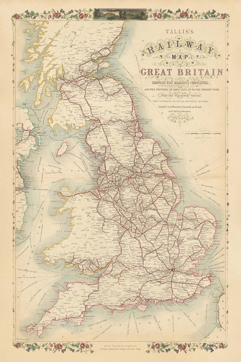
Betreten Sie die dynamische Welt des viktorianischen Großbritanniens mit „Tallis’ Railway Map of Great Britain Showing the Railways Completed, and the Stations...
WeiterlesenBetreten Sie die dynamische Welt des viktorianischen Großbritanniens mit „Tallis’ Railway Map of Great Britain Showing the Railways Completed, and the Stations on Each Line, Up To The Present Time, with the Steamboat Tracks From the Principal British and Continental Ports.“ Diese Karte, die 1850 vom gefeierten Verleger John Tallis und dem geschickten Graveur John Rapkin erstellt wurde, ist ein Zeugnis des fieberhaften Innovations- und Vernetzungsdrangs dieser Ära. Auf einen Blick zeigt sie das komplexe Netz von Eisenbahnen, das die Landschaft verwandelte und die großen Städte und Gemeinden Englands, Schottlands und Wales während des Höhepunkts der Industriellen Revolution miteinander verband.
John Tallis, bekannt für seine eleganten und dekorativen kartografischen Werke, verlieh dieser Karte ein Gefühl von Größe und Klarheit. In Zusammenarbeit mit John Rapkin, dessen akribisches Gravieren die Details zum Leben erweckte, stellte Tallis sicher, dass jede Linie und Station nicht nur genau – mühsam aus Regierungsdokumenten und den neuesten Eisenbahninformationen zusammengestellt – sondern auch visuell fesselnd war. Der kunstvolle Rahmen der Karte ist wunderschön.
Der thematische Fokus der Karte auf Eisenbahnen und Dampfschiffrouten fasst die tiefgreifenden Veränderungen des mittleren 19. Jahrhunderts zusammen. Wichtige Eisenbahnlinien strahlen von London, Birmingham, Manchester und Glasgow aus und verbinden aufstrebende Industriezentren mit Küstenhäfen und ländlichen Hinterlandschaften. Dampfschifffahrten ziehen sich über die Nordsee, den Ärmelkanal und die Irische See und verbinden britische Häfen mit dem europäischen Festland und unterstreichen die globale Reichweite des britischen Handels. Jede Eisenbahnstation und Route ist sorgfältig markiert und bietet einen Schnappschuss eines Landes, das sich inmitten beispielloser Mobilität und wirtschaftlicher Transformation befindet.
Über seine Verkehrsnetze hinaus ist die Karte eine Feier von Britanniens reicher und vielfältiger Geografie. Die sanften Hügel von Wales, die rauen Highlands von Schottland und die fruchtbaren Ebenen Englands werden alle subtil angedeutet, während große Flüsse wie die Themse, der Severn und der Clyde ihren Weg durch die Landschaft bahnen. Dekorative Illustrationen beschwören den Geist der Zeit: mächtige Brücken, geschäftige Häfen und die stolze Figur von Britannia, alles vor dem Hintergrund natürlicher Schönheit und industrieller Stärke. Die Grenzen zwischen England, Schottland und Wales sind deutlich abgegrenzt, und die Grafschaftsgrenzen bieten weitere Einblicke in die Verwaltungslandschaft der damaligen Zeit.
Diese Karte ist mehr als ein Navigationshilfsmittel; sie ist ein historisches Dokument, das das Wesen einer Nation auf der Reise einfängt. Sie zeichnet den Aufstieg von Städten wie London, Birmingham, Liverpool und Glasgow – heute globale Metropolen – nach und dokumentiert die Namen von Städten und Regionen, die die britische Identität seit Jahrhunderten geprägt haben. Ob bewundert für ihre Kunstfertigkeit, ihre historische Bedeutung oder ihren schieren Ehrgeiz, lädt diese Karte den Betrachter ein, zu einem entscheidenden Moment in der Geschichte Großbritanniens zurückzukehren, als Eisenbahnschienen und Dampfkraft die Konturen des Alltags neu zeichneten.
Städte und Gemeinden auf dieser Karte
-
England
- London
- Birmingham
- Manchester
- Liverpool
- Leeds
- Sheffield
- Newcastle (Newcastle upon Tyne)
- Bristol
- Nottingham
- Leicester
- Portsmouth
- Southampton
- Derby
- York
- Norwich
- Exeter
- Carlisle
- Plymouth
- Hull (Kingston upon Hull)
- Sunderland
- Wolverhampton
- Stoke (Stoke-on-Trent)
- Preston
- Lancaster
- Chester
- Bath
- Oxford
- Cambridge
- Brighton
-
Schottland
- Glasgow
- Edinburgh
- Aberdeen
- Dundee
- Inverness
- Perth
- Stirling
-
Wales
- Cardiff
- Swansea
- Newport
- Bangor
- Wrexham
Bemerkenswerte Merkmale & Wahrzeichen
- Dekorativer Rand: Verschnörkelter, floraler und scrollwerkähnlicher Rand, der die Karte umrahmt, typisch für Tallis’ Veröffentlichungen
- Gewässer:
- Die Nordsee (als Deutscher Ozean bezeichnet)
- Der Ärmelkanal
- Die Irische See
- Verschiedene Mündungen und Buchten (z.B. Firth of Forth, Solway Firth)
- Grenzen:
- Deutlich abgegrenzte Grenzen zwischen England, Schottland und Wales
- Landkreisgrenzen innerhalb jedes Landes
- Dampfschiffspuren: Gepunktete oder hervorgehobene Linien über das Meer, die britische Häfen mit kontinentalen Zielen verbinden
- Eisenbahnen: Deutlich gekennzeichnete Eisenbahnlinien, die das Land durchkreuzen, mit angegebenen Bahnhöfen
- Berge und Gelände: Hügeliges und bergiges Gelände, besonders in Schottland und Wales, jedoch stilisiert und nicht topografisch genau
- Wichtige Flüsse (z.B. Themse, Severn, Mersey, Clyde) sind beschriftet
Historischer und gestalterischer Kontext
- Erstellt im Jahr 1850, zur Zeit der Hochphase der Industriellen Revolution
- Veröffentlicht von John Tallis, einem renommierten Verleger des 19. Jahrhunderts, bekannt für elegante und dekorative Karten
- Kartografie von John Rapkin, einem geschickten Graveur und häufigen Mitarbeiter von Tallis
- Thematischer Fokus auf die Eisenbahninfrastruktur und Dampfschiffsrouten, die die rasante industrielle und sozioökonomische Transformation Großbritanniens widerspiegeln
- Akribisch aus Regierungsdokumenten und den neuesten Eisenbahninformationen der damaligen Zeit zusammengestellt
- Erfasst die Expansion der britischen Eisenbahnen und die erhöhte nationale Mobilität
- Dekorative Ränder und gravierte Illustrationen erhöhen sowohl die visuelle Anziehungskraft als auch den historischen Wert
- Dient als primäre Quelle für das Verständnis des britischen Verkehrs und der Geografie im mittleren 19. Jahrhundert
- Bietet Einblicke in die administrative Landschaft mit deutlich markierten Landkreisgrenzen
Bitte überprüfen Sie die Bilder, um sicherzustellen, dass eine bestimmte Stadt oder ein Ort auf dieser Karte angezeigt wird. Sie können auch Kontakt aufnehmen und uns bitten, die Karte für Sie zu überprüfen.
Diese Karte sieht in jeder Größe großartig aus, aber ich empfehle immer, eine größere Größe zu wählen, wenn Sie Platz haben. So können Sie alle Details leicht erkennen.
Diese Karte sieht bis zu 90 Zoll (230 cm) großartig aus. Wenn Sie nach einer größeren Karte suchen, bitte nehmen Sie Kontakt auf.
Bitte beachten Sie: Die Beschriftungen auf dieser Karte sind schwer zu lesen, wenn Sie eine Karte bestellen, die 16 Zoll (40 cm) oder kleiner ist. Die Karte ist immer noch sehr attraktiv, aber wenn Sie die Karte leicht lesen möchten, kaufen Sie bitte eine größere Größe.
Das Modell in den Angebotsbildern hält die 24x36 Zoll (60x90 cm) Version dieser Karte.
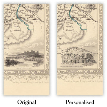
Das fünfte Angebotsbild zeigt ein Beispiel für meinen Personalisierungsservice für Karten.
Wenn Sie nach etwas leicht anderem suchen, schauen Sie sich meine Sammlung der besten alten Karten an, um zu sehen, ob etwas anderes Ihr Interesse weckt.
Bitte kontaktieren Sie mich, um zu überprüfen, ob ein bestimmter Ort, ein Wahrzeichen oder ein Merkmal auf dieser Karte angezeigt wird.
Dies wäre ein wunderbares Geschenk zum Geburtstag, Weihnachten, Vatertag, Abschied von der Arbeit, Jubiläum oder zur Einweihung für jemanden aus den in dieser Karte abgedeckten Bereichen.
Diese Karte ist als Giclée-Druck auf säurefreiem, archivierbarem mattem Papier erhältlich, oder Sie können sie gerahmt kaufen. Der Rahmen ist ein schöner, einfacher schwarzer Rahmen, der zu den meisten Ästhetiken passt. Bitte kontaktieren Sie mich, wenn Sie eine andere Rahmenfarbe oder -material wünschen. Meine Rahmen sind mit superklarem, museumsgrauem Acryl (Plexiglas/Acrylit) verglast, das erheblich weniger reflektierend als Glas ist, sicherer ist und immer in einwandfreiem Zustand ankommt.
This map is also available as a float framed canvas, sometimes known as a shadow gap framed canvas or canvas floater. The map is printed on artist's cotton canvas and then stretched over a handmade box frame. We then "float" the canvas inside a wooden frame, which is available in a range of colours (black, dark brown, oak, antique gold and white). This is a wonderful way to present a map without glazing in front. See some examples of float framed canvas maps and explore the differences between my different finishes.
For something truly unique, this map is also available in "Unique 3D", our trademarked process that dramatically transforms the map so that it has a wonderful sense of depth. We combine the original map with detailed topography and elevation data, so that mountains and the terrain really "pop". For more info and examples of 3D maps, check my Unique 3D page.
Betreten Sie die dynamische Welt des viktorianischen Großbritanniens mit „Tallis’ Railway Map of Great Britain Showing the Railways Completed, and the Stations on Each Line, Up To The Present Time, with the Steamboat Tracks From the Principal British and Continental Ports.“ Diese Karte, die 1850 vom gefeierten Verleger John Tallis und dem geschickten Graveur John Rapkin erstellt wurde, ist ein Zeugnis des fieberhaften Innovations- und Vernetzungsdrangs dieser Ära. Auf einen Blick zeigt sie das komplexe Netz von Eisenbahnen, das die Landschaft verwandelte und die großen Städte und Gemeinden Englands, Schottlands und Wales während des Höhepunkts der Industriellen Revolution miteinander verband.
John Tallis, bekannt für seine eleganten und dekorativen kartografischen Werke, verlieh dieser Karte ein Gefühl von Größe und Klarheit. In Zusammenarbeit mit John Rapkin, dessen akribisches Gravieren die Details zum Leben erweckte, stellte Tallis sicher, dass jede Linie und Station nicht nur genau – mühsam aus Regierungsdokumenten und den neuesten Eisenbahninformationen zusammengestellt – sondern auch visuell fesselnd war. Der kunstvolle Rahmen der Karte ist wunderschön.
Der thematische Fokus der Karte auf Eisenbahnen und Dampfschiffrouten fasst die tiefgreifenden Veränderungen des mittleren 19. Jahrhunderts zusammen. Wichtige Eisenbahnlinien strahlen von London, Birmingham, Manchester und Glasgow aus und verbinden aufstrebende Industriezentren mit Küstenhäfen und ländlichen Hinterlandschaften. Dampfschifffahrten ziehen sich über die Nordsee, den Ärmelkanal und die Irische See und verbinden britische Häfen mit dem europäischen Festland und unterstreichen die globale Reichweite des britischen Handels. Jede Eisenbahnstation und Route ist sorgfältig markiert und bietet einen Schnappschuss eines Landes, das sich inmitten beispielloser Mobilität und wirtschaftlicher Transformation befindet.
Über seine Verkehrsnetze hinaus ist die Karte eine Feier von Britanniens reicher und vielfältiger Geografie. Die sanften Hügel von Wales, die rauen Highlands von Schottland und die fruchtbaren Ebenen Englands werden alle subtil angedeutet, während große Flüsse wie die Themse, der Severn und der Clyde ihren Weg durch die Landschaft bahnen. Dekorative Illustrationen beschwören den Geist der Zeit: mächtige Brücken, geschäftige Häfen und die stolze Figur von Britannia, alles vor dem Hintergrund natürlicher Schönheit und industrieller Stärke. Die Grenzen zwischen England, Schottland und Wales sind deutlich abgegrenzt, und die Grafschaftsgrenzen bieten weitere Einblicke in die Verwaltungslandschaft der damaligen Zeit.
Diese Karte ist mehr als ein Navigationshilfsmittel; sie ist ein historisches Dokument, das das Wesen einer Nation auf der Reise einfängt. Sie zeichnet den Aufstieg von Städten wie London, Birmingham, Liverpool und Glasgow – heute globale Metropolen – nach und dokumentiert die Namen von Städten und Regionen, die die britische Identität seit Jahrhunderten geprägt haben. Ob bewundert für ihre Kunstfertigkeit, ihre historische Bedeutung oder ihren schieren Ehrgeiz, lädt diese Karte den Betrachter ein, zu einem entscheidenden Moment in der Geschichte Großbritanniens zurückzukehren, als Eisenbahnschienen und Dampfkraft die Konturen des Alltags neu zeichneten.
Städte und Gemeinden auf dieser Karte
-
England
- London
- Birmingham
- Manchester
- Liverpool
- Leeds
- Sheffield
- Newcastle (Newcastle upon Tyne)
- Bristol
- Nottingham
- Leicester
- Portsmouth
- Southampton
- Derby
- York
- Norwich
- Exeter
- Carlisle
- Plymouth
- Hull (Kingston upon Hull)
- Sunderland
- Wolverhampton
- Stoke (Stoke-on-Trent)
- Preston
- Lancaster
- Chester
- Bath
- Oxford
- Cambridge
- Brighton
-
Schottland
- Glasgow
- Edinburgh
- Aberdeen
- Dundee
- Inverness
- Perth
- Stirling
-
Wales
- Cardiff
- Swansea
- Newport
- Bangor
- Wrexham
Bemerkenswerte Merkmale & Wahrzeichen
- Dekorativer Rand: Verschnörkelter, floraler und scrollwerkähnlicher Rand, der die Karte umrahmt, typisch für Tallis’ Veröffentlichungen
- Gewässer:
- Die Nordsee (als Deutscher Ozean bezeichnet)
- Der Ärmelkanal
- Die Irische See
- Verschiedene Mündungen und Buchten (z.B. Firth of Forth, Solway Firth)
- Grenzen:
- Deutlich abgegrenzte Grenzen zwischen England, Schottland und Wales
- Landkreisgrenzen innerhalb jedes Landes
- Dampfschiffspuren: Gepunktete oder hervorgehobene Linien über das Meer, die britische Häfen mit kontinentalen Zielen verbinden
- Eisenbahnen: Deutlich gekennzeichnete Eisenbahnlinien, die das Land durchkreuzen, mit angegebenen Bahnhöfen
- Berge und Gelände: Hügeliges und bergiges Gelände, besonders in Schottland und Wales, jedoch stilisiert und nicht topografisch genau
- Wichtige Flüsse (z.B. Themse, Severn, Mersey, Clyde) sind beschriftet
Historischer und gestalterischer Kontext
- Erstellt im Jahr 1850, zur Zeit der Hochphase der Industriellen Revolution
- Veröffentlicht von John Tallis, einem renommierten Verleger des 19. Jahrhunderts, bekannt für elegante und dekorative Karten
- Kartografie von John Rapkin, einem geschickten Graveur und häufigen Mitarbeiter von Tallis
- Thematischer Fokus auf die Eisenbahninfrastruktur und Dampfschiffsrouten, die die rasante industrielle und sozioökonomische Transformation Großbritanniens widerspiegeln
- Akribisch aus Regierungsdokumenten und den neuesten Eisenbahninformationen der damaligen Zeit zusammengestellt
- Erfasst die Expansion der britischen Eisenbahnen und die erhöhte nationale Mobilität
- Dekorative Ränder und gravierte Illustrationen erhöhen sowohl die visuelle Anziehungskraft als auch den historischen Wert
- Dient als primäre Quelle für das Verständnis des britischen Verkehrs und der Geografie im mittleren 19. Jahrhundert
- Bietet Einblicke in die administrative Landschaft mit deutlich markierten Landkreisgrenzen
Bitte überprüfen Sie die Bilder, um sicherzustellen, dass eine bestimmte Stadt oder ein Ort auf dieser Karte angezeigt wird. Sie können auch Kontakt aufnehmen und uns bitten, die Karte für Sie zu überprüfen.
Diese Karte sieht in jeder Größe großartig aus, aber ich empfehle immer, eine größere Größe zu wählen, wenn Sie Platz haben. So können Sie alle Details leicht erkennen.
Diese Karte sieht bis zu 90 Zoll (230 cm) großartig aus. Wenn Sie nach einer größeren Karte suchen, bitte nehmen Sie Kontakt auf.
Bitte beachten Sie: Die Beschriftungen auf dieser Karte sind schwer zu lesen, wenn Sie eine Karte bestellen, die 16 Zoll (40 cm) oder kleiner ist. Die Karte ist immer noch sehr attraktiv, aber wenn Sie die Karte leicht lesen möchten, kaufen Sie bitte eine größere Größe.
Das Modell in den Angebotsbildern hält die 24x36 Zoll (60x90 cm) Version dieser Karte.
Das fünfte Angebotsbild zeigt ein Beispiel für meinen Personalisierungsservice für Karten.
Wenn Sie nach etwas leicht anderem suchen, schauen Sie sich meine Sammlung der besten alten Karten an, um zu sehen, ob etwas anderes Ihr Interesse weckt.
Bitte kontaktieren Sie mich, um zu überprüfen, ob ein bestimmter Ort, ein Wahrzeichen oder ein Merkmal auf dieser Karte angezeigt wird.
Dies wäre ein wunderbares Geschenk zum Geburtstag, Weihnachten, Vatertag, Abschied von der Arbeit, Jubiläum oder zur Einweihung für jemanden aus den in dieser Karte abgedeckten Bereichen.
Diese Karte ist als Giclée-Druck auf säurefreiem, archivierbarem mattem Papier erhältlich, oder Sie können sie gerahmt kaufen. Der Rahmen ist ein schöner, einfacher schwarzer Rahmen, der zu den meisten Ästhetiken passt. Bitte kontaktieren Sie mich, wenn Sie eine andere Rahmenfarbe oder -material wünschen. Meine Rahmen sind mit superklarem, museumsgrauem Acryl (Plexiglas/Acrylit) verglast, das erheblich weniger reflektierend als Glas ist, sicherer ist und immer in einwandfreiem Zustand ankommt.
This map is also available as a float framed canvas, sometimes known as a shadow gap framed canvas or canvas floater. The map is printed on artist's cotton canvas and then stretched over a handmade box frame. We then "float" the canvas inside a wooden frame, which is available in a range of colours (black, dark brown, oak, antique gold and white). This is a wonderful way to present a map without glazing in front. See some examples of float framed canvas maps and explore the differences between my different finishes.
For something truly unique, this map is also available in "Unique 3D", our trademarked process that dramatically transforms the map so that it has a wonderful sense of depth. We combine the original map with detailed topography and elevation data, so that mountains and the terrain really "pop". For more info and examples of 3D maps, check my Unique 3D page.
Many of our maps and art prints are chosen as thoughtful gifts for homes, offices, studies and meaningful places.
Choose a framed option for the easiest ready-to-hang gift, or choose an unframed print if the recipient may prefer to select their own frame.
We make orders locally in 23 countries around the world, so gifts can often be produced close to the recipient. This helps them arrive faster, travel more safely, and avoid customs or import duty surprises.
- We can deliver directly to the recipient
- Framed pieces arrive ready to hang
- Unframed prints are carefully packed in a strong protective tube
- Almost every order is made locally, for faster, safer gifting
- 90-day returns give the recipient time to decide
If you are not sure what to choose, please contact us. We can help you pick the right map, size, finish or delivery option.
Für die meisten Bestellungen beträgt die Lieferzeit etwa 3 Werktage. Personalisierte und maßgeschneiderte Produkte benötigen länger, da ich die Personalisierung durchführen und sie Ihnen zur Genehmigung zusenden muss, was normalerweise 1 oder 2 Tage dauert.
Bitte beachten Sie, dass sehr große gerahmte Bestellungen in der Regel länger für die Herstellung und Lieferung benötigen.
Wenn Sie möchten, dass Ihre Bestellung bis zu einem bestimmten Datum ankommt, bitte kontaktieren Sie mich, bevor Sie bestellen, damit wir den besten Weg finden können, um sicherzustellen, dass Sie Ihre Bestellung rechtzeitig erhalten.
Ich drucke und rahme Karten und Kunstwerke in 23 Ländern weltweit. Das bedeutet, dass Ihre Bestellung lokal gefertigt wird, was die Lieferzeit verkürzt und sicherstellt, dass sie während der Lieferung nicht beschädigt wird. Sie zahlen nie Zoll oder Einfuhrgebühren, und wir stoßen weniger CO2 in die Luft aus.
Alle meine Karten und Kunstdrucke sind gut verpackt und werden in einem robusten Rohr versendet, wenn sie ungerahmt sind, oder von Schaum umgeben, wenn sie gerahmt sind.
Ich versuche, alle Bestellungen innerhalb von 1 oder 2 Tagen nach Erhalt Ihrer Bestellung zu versenden, obwohl einige Produkte (wie Gesichtsmasken, Tassen und Tragetaschen) länger zur Herstellung benötigen können.
Wenn Sie Express-Lieferung an der Kasse auswählen, priorisieren wir Ihre Bestellung und versenden sie per 1-Tages-Kurier (Fedex, DHL, UPS, Parcelforce).
Nächster Tag Lieferung ist auch in einigen Ländern verfügbar (USA, UK, Singapur, VAE), aber bitte versuchen Sie, früh am Tag zu bestellen, damit wir es rechtzeitig versenden können.
Lesen Sie meinen vollständigen Leitfaden zur Lieferung und lokalen Produktion
Mein Standardrahmen ist ein Galerie-Stil-Rahmen aus schwarzem Eschenholz. Er ist einfach und sieht ziemlich modern aus. Mein Standardrahmen ist etwa 20 mm (0,8 Zoll) breit.
Ich verwende super-klares Acryl (Plexiglas/Acrylt) für das Glas des Rahmens. Es ist leichter und sicherer als Glas – und es sieht besser aus, da die Reflexion geringer ist.
Sechs Standardrahmenfarben sind kostenlos erhältlich (schwarz, dunkelbraun, dunkelgrau, Eiche, weiß und antikgold).
Die meisten Karten, Kunstwerke und Illustrationen sind auch als gerahmte Leinwand erhältlich. Wir verwenden matte (nicht glänzende) Baumwollleinwand, spannen sie über einen nachhaltig beschafften Buchenrahmen und 'schweben' dann das Stück innerhalb eines Holzrahmens. Das Endergebnis ist ziemlich schön, und es gibt keine Verglasung, die im Weg ist.
Alle Rahmen werden "bereit zum Aufhängen" geliefert, entweder mit einer Schnur oder Halterungen auf der Rückseite. Sehr große Rahmen haben schwere Aufhängeplatten und/oder eine Montageschiene. Wenn Sie Fragen haben, können Sie bitte Kontakt aufnehmen.
Sehen Sie sich einige Beispiele meiner gerahmten Karten und gerahmten Leinwandkarten an.
Alternativ kann ich auch alte Karten und Kunstwerke auf Leinwand, Schaumstoffplatten, Baumwollrag und andere Materialien liefern.
Wenn Sie Ihre Karte oder Ihr Kunstwerk selbst rahmen möchten, lesen Sie bitte zuerst meinen Größenleitfaden.
Meine Karten sind äußerst hochwertige Reproduktionen von Originalkarten.
Ich beziehe originale, seltene Karten aus Bibliotheken, Auktionshäusern und Privatsammlungen auf der ganzen Welt, restauriere sie in meiner Londoner Werkstatt und erstelle dann mit speziellen Giclée-Tinten und -Druckern wunderschöne Karten, die sogar noch besser aussehen als das Original.
Meine Karten werden auf säurefreiem, mattem Archivpapier (nicht glänzend) gedruckt, das sich sehr hochwertig anfühlt und fast wie Karton aussieht. Technisch gesehen beträgt das Papiergewicht/die Papierdicke 10mil/200g/m². Es eignet sich perfekt zum Einrahmen.
Ich drucke mit UV-lichtbeständigen Ultrachrome-Giclée-Pigmenttinten von Epson – einige der besten Tinten, die Sie finden können.
Ich kann auch machen Karten auf Leinwand, Baumwolllappen und andere exotische Materialien.
Erfahren Sie mehr über The Unique Maps Co.
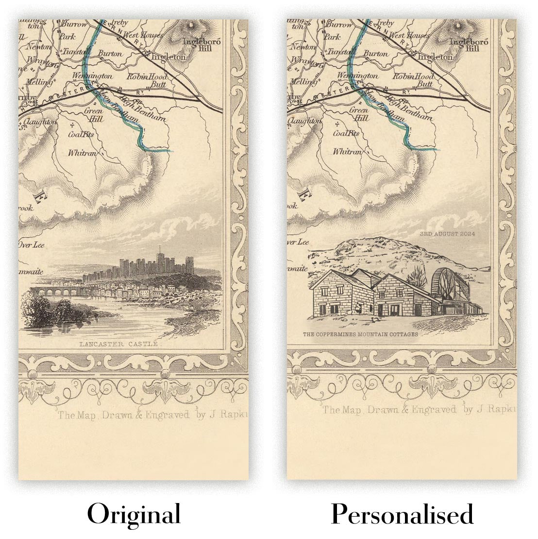
Kartenpersonalisierung
Wenn Sie nach dem perfekten Geschenk zum Jahrestag oder zur Einweihung suchen, kann ich Ihre Karte personalisieren, um sie wirklich einzigartig zu machen. Ich kann beispielsweise eine kurze Nachricht hinzufügen, einen wichtigen Ort hervorheben oder das Wappen Ihrer Familie hinzufügen.
Die Möglichkeiten sind nahezu unbegrenzt. Bitte sehen Sie sich meine Kartenpersonalisierungsseite für einige wunderbare Beispiele dessen, was möglich ist.
Um eine personalisierte Karte zu bestellen, wählen Sie „Personalisieren Sie Ihre Karte“, bevor Sie sie in den Warenkorb legen.
In Kontakt kommen wenn Sie nach komplexeren Anpassungen und Personalisierungen suchen.
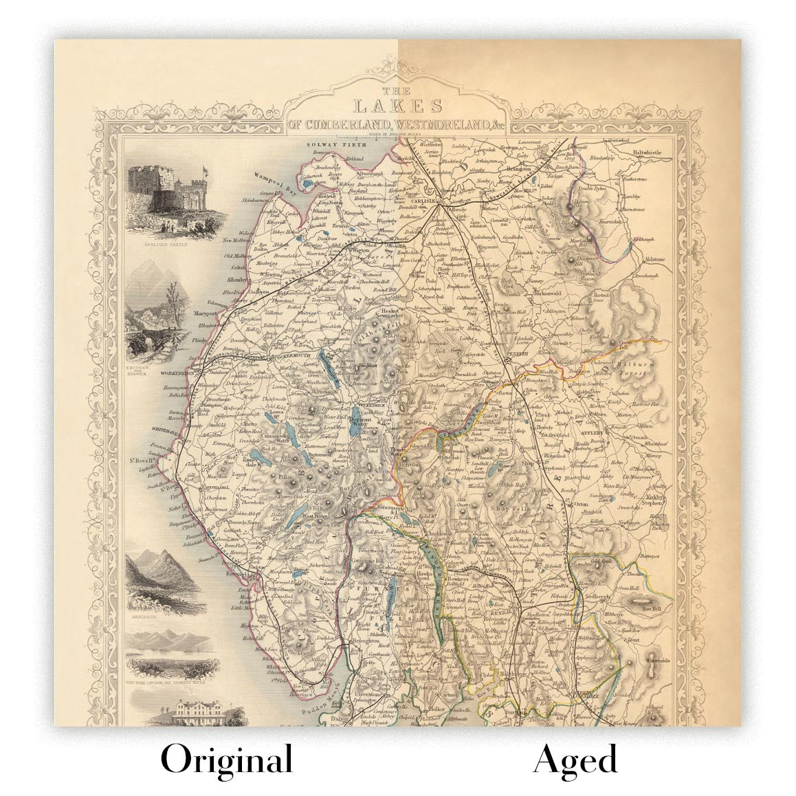
Kartenalterung
Im Laufe der Jahre wurde ich von Kunden hunderte Male gefragt, ob sie eine Karte kaufen könnten, die noch älter.
Nun, jetzt können Sie das, indem Sie „Alter“ auswählen, bevor Sie eine Karte in Ihren Warenkorb legen.
Alle Produktfotos, die Sie auf dieser Seite sehen, zeigen die Karte in ihrer Originalform. So sieht die Karte heute aus.
Wenn Sie „Gealtert“ auswählen, werde ich Ihre Karte von Hand altern lassen. Dazu verwende ich ein spezielles und einzigartiges Verfahren, das ich durch jahrelanges Studium alter Karten und Gespräche mit Forschern zum Verständnis der Chemie alternder Papiere entwickelt habe, und natürlich ... viel Übung!
Wenn Sie sich nicht sicher sind, bleiben Sie bei der Originalfarbe der Karte. Wenn Sie etwas Dunkleres und älter Wenn Sie auf der Suche sind, entscheiden Sie sich für „Aged“.
Sehen Sie einige erstaunliche Beispiele für gealterte Karten.
Wenn Sie aus irgendeinem Grund mit Ihrer Bestellung nicht zufrieden sind, kontaktieren Sie mich für eine unkomplizierte Rückerstattung. Bitte sehen Sie sich unsere Rückgabe- und Rückerstattungsrichtlinien für weitere Informationen an.
Ich bin sehr zuversichtlich, dass Ihnen Ihre restaurierte Karte oder Kunstdruck gefallen wird. Ich mache das seit 1984. Ich bin ein 5-Sterne Etsy-Verkäufer. Ich habe Zehntausende von Karten und Kunstdrucken verkauft und habe über 5.000 echte 5-Sterne-Bewertungen.
Ich verwende einen einzigartigen Prozess, um Karten und Kunstwerke zu restaurieren, der extrem zeitaufwendig und arbeitsintensiv ist. Die Suche nach den Originalkarten und Illustrationen kann Monate dauern. Ich benutze modernste und unglaublich teure Technologie, um sie zu scannen und wiederherzustellen. Daher garantiere ich, dass meine Karten und Kunstdrucke eine Klasse für sich sind - deshalb kann ich eine unkomplizierte Rückerstattung anbieten.
Fast alle meine Karten und Kunstdrucke sehen in großen Größen (200 cm, 6,5 Fuß+) erstaunlich aus und ich kann sie Ihnen auch gerahmt und über einen speziellen Übergrößen-Kurier liefern. Kontaktieren Sie mich, um Ihre speziellen Bedürfnisse zu besprechen.
Or try searching for something!


