


Alter bildlicher Stadtplan der pazifischen Wirtschaft von Covarrubias, 1940: Handel, Ressourcen, Kunst vor dem Zweiten Weltkrieg
20% Rabatt auf 2 — 33% Rabatt auf 3
Fügen Sie beliebige zwei berechtigte Artikel zu Ihrem Warenkorb hinzu, um 20% Rabatt zu erhalten. Fügen Sie einen dritten hinzu und er ist kostenlos (entspricht 33% Rabatt, wenn Sie drei kaufen).
Kein Code erforderlich — das Angebot wird automatisch an der Kasse angewendet.
Gültig für alle Standardkarten und Kunstdrucke. Sie können beliebige Designs kombinieren.
Wenn Sie Artikel an mehrere Adressen versenden möchten, kontaktieren Sie uns bitte, bevor Sie Ihre Bestellung aufgeben.
Maßanfertigungen und individuelle Aufträge sind ausgeschlossen.
Kontaktieren Sie uns wenn Sie Fragen haben
-
![]() Handmade in the USA
Handmade in the USA

-
FREE worldwide delivery in 2-3 days ⓘ
Free delivery in 2-3 days
Your map should be delivered in 2-3 working days with free delivery, worldwide.
We make maps by hand locally in 23 countries. If you're buying a gift for someone in another country, we will make the map locally to them.
You will never pay import tax or customs duty.
Express delivery is available at checkout which can reduce the delivery time to 1-2 days.
Please note that personalised maps, and larger framed maps, can take longer to produce and deliver.
If you need your order to arrive by a certain date, contact me and we can discuss your options.
-
Complimentary gifting & design advice
ⓘ
Complimentary gifting & design advice
Available almost 24/7 on WhatsApp and email — we usually reply within minutes. We can help you:
- Choose a perfectly personalised gift
- Send a digital gift preview to the recipient
- Pick the ideal size for your wall
- Select the right finish and frame
Quick, friendly advice so you can order with confidence.
For last minute gifts, consider buying a digital gift card. We have over 5,000 maps and art prints to choose from.
-
90-day returns & 5-year guarantee
ⓘ
90 Tage für Rückgabe und Rückerstattung
Produkte können innerhalb von 90 Tagen für eine vollständige Rückerstattung oder einen Umtausch gegen ein anderes Produkt zurückgegeben werden.
Für personalisierte und maßgefertigte Artikel können wir Ihnen möglicherweise einen Gutschein oder eine nicht ablaufende Geschenkkarte anbieten, da wir personalisierte Bestellungen nicht weiterverkaufen können.
Wenn Sie Fragen haben, kontaktieren Sie uns. Für weitere Informationen siehe unsere vollständige Rückgabe- und Umtauschrichtlinie.

This is a museum-grade archival print from the original 1940 map — restored in our workshop and made to order on 220gsm archival matte paper or 400gsm artist's cotton canvas with pigment inks.
Professional framing & free personalisation available.
1. Choose a size
2. Frame & personalize your map
Make your map unique with framing, hand-drawn customisation, vintage ageing, pop art text, unique 3D styling and more.


Geschenkmitteilung & individuelle Ausführung

Wenn Sie eine Geschenkmitteilung oder eine Ausführung (Puzzle, Aluminiumplatte usw.) hinzufügen möchten, die hier nicht verfügbar ist, geben Sie dies bitte in der "Bestellnotiz" beim Checkout an.
Jede Bestellung wird individuell angefertigt. Wenn Sie die Größe leicht anpassen oder auf einem ungewöhnlichen Material drucken lassen möchten, lassen Sie es uns einfach wissen. Wir haben im Laufe der Jahre Tausende von individuellen Bestellungen bearbeitet, daher gibt es (fast) nichts, was wir nicht bewältigen können.
Sie können uns auch kontaktieren, bevor Sie bestellen, wenn Sie möchten!

- Handmade locally. No import duty or tax
- FREE worldwide delivery
- 90-day returns & 5-year product guarantee
- Questions? WhatsApp me any time
Own a piece of history
7,000+ 5 star reviews


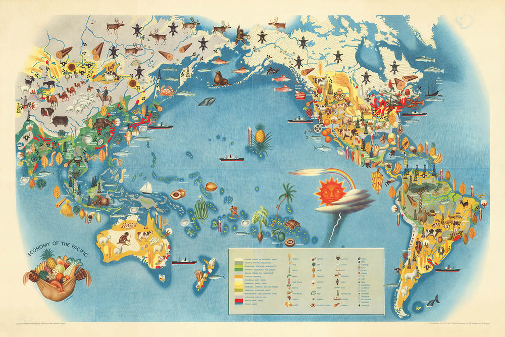
Betreten Sie die lebendige Welt des Handels im pazifischen Raum vor dem Krieg mit "Wirtschaft des Pazifiks", dem originalen Meisterwerk von Miguel Covarrubias aus dem Jahr 1940. Diese außergewöhnliche bildliche Karte, die für die gefeierte Reihe "Pageant of the Pacific" konzipiert wurde, wurde für die Golden Gate International Exposition 1939 in San Francisco in Auftrag gegeben. Covarrubias, oft als "Mexikos Renaissance-Mann" gefeiert, vereint seine Talente als Maler, Illustrator und Anthropologe, um eine Karte zu schaffen, die sowohl intellektuell reich als auch visuell fesselnd ist. Der Titel der Karte allein evoziert eine umfassende Vision des globalen Handels, der Industrie und der Einfallsreichtum und fasst den Dynamismus des pazifischen Raums am Vorabend monumentaler historischer Veränderungen zusammen.
Covarrubias' "Wirtschaft des Pazifiks" ist mehr als ein geografisches Dokument – es ist ein thematisches Wandteppich, der das wirtschaftliche Lebenselixier einer ganzen Region miteinander verwebt. Die Karte veranschaulicht lebhaft die wichtigsten Industrien und Ressourcen, die die pazifische Welt im frühen zwanzigsten Jahrhundert prägten, von den Goldfeldern Alaskas bis zu den Reisfeldern Südostasiens und den geschäftigen Fischereien Japans. Durch eine lebendige Reihe von bildlichen Symbolen und handgezeichneten Anmerkungen werden die Betrachter eingeladen, die wirtschaftlichen Verbindungen zu erkunden, die Kontinente und Ozeane überspannten und die Schicksale von Nationen und Völkern prägten.
Das Design der Karte ist eine Meisterklasse in stilisierter Kartografie. Covarrubias verwendet einen bildlichen Ansatz, der strikte politische Grenzen zugunsten von reichhaltig detaillierten Illustrationen meidet, die wirtschaftliche Aktivitäten und natürliche Ressourcen hervorheben. Schiffe, beladen mit Waren, durchqueren die weite Ausdehnung des Pazifiks, während Vignetten von Minenarbeitern, Landwirten und Fischern die Küsten und Inseln beleben. Dekorative Ränder und Illustrationen in den Ecken fügen weitere Tiefe hinzu und verwandeln die Karte in ein Kunstwerk, das das Auge erfreut und den Verstand informiert. Die Projektion und Komposition der Karte betonen den Pazifischen Ozean als zentrale Bühne und vereinen die Amerikas, Asien, Australien und die unzähligen Inselkulturen dazwischen.
Historisch gesehen steht diese Karte als Momentaufnahme einer Welt am Rande der Transformation. Kurz vor dem Ausbruch des Zweiten Weltkriegs geschaffen, spiegelt "Wirtschaft des Pazifiks" sowohl den Optimismus als auch die Komplexität der Zwischenkriegszeit wider. Sie fängt die Faszination der Ära für Fortschritt, Ressourcengewinnung und globale Vernetzung ein, während sie subtil die Vielfalt der Völker und Kulturen anerkennt, die zum wirtschaftlichen Mosaik des Pazifiks beigetragen haben. Covarrubias' anthropologischer Einblick durchdringt die Karte mit einem Gefühl von Menschlichkeit und macht sie zu einem wertvollen Artefakt für Historiker, Sammler und jeden, der die Wechselwirkungen zwischen Kunst und Geschichte schätzt.
Besitz von "Wirtschaft des Pazifiks" bedeutet, ein seltenes Fenster in den künstlerischen und intellektuellen Aufbruch der späten 1930er und frühen 1940er Jahre zu besitzen. Ob in einem Arbeitszimmer, einer Bibliothek oder einer Galerie ausgestellt, bietet diese Karte endlose Faszination – sie lädt die Betrachter ein, die Routen antiker Händler nachzuvollziehen, sich das Leben von Arbeitern und Abenteurern vorzustellen und das bleibende Erbe von Covarrubias' Vision zu schätzen. Sie ist ein Zeugnis für die Macht von Karten, nicht nur Geografie zu kartieren, sondern auch die Geschichten von Zivilisationen an den Kreuzungen des Wandels zu erzählen.
Länder und Regionen auf dieser Karte
- Nordamerika (einschließlich Kanada, Vereinigte Staaten, Mexiko)
- Mittelamerika
- Südamerika (insbesondere die Pazifikküste)
- Ostasien (einschließlich China, Japan, Korea)
- Südostasien (einschließlich der Philippinen, Indonesien, Malaysia, Indochina)
- Australien
- Neuseeland
- Pazifische Inseln (einschließlich Hawaii, Fidschi, Papua-Neuguinea, Salomonen und andere)
- Sibirien (Russischer Fernost)
- Alaska
Bemerkenswerte Merkmale & Wahrzeichen
- Illustrierte Darstellungen wirtschaftlicher Aktivitäten wie Fischerei, Walfang, Bergbau, Landwirtschaft, Forstwirtschaft und Handel
- Bildliche Symbole für Ressourcen wie Öl, Mineralien, Holz, Reis, Zucker und Fisch
- Darstellungen von Schiffen, Booten und Seewegen, die den Pazifischen Ozean durchkreuzen
- Stilisierte Illustrationen von Arbeitern, Landwirten und indigenen Völkern, die an wirtschaftlichen Aktivitäten beteiligt sind
- Große, beschriftete Gewässer: Pazifischer Ozean, Beringmeer, Korallenmeer, Tasmansee, Japanisches Meer, Südchinesisches Meer, Philippinisches Meer und andere
- Wichtige Gebirgszüge illustriert, wie die Anden und die Rockies
- Dekorative Ränder und Eckenvignetten, die wirtschaftliche Szenen oder Produkte zeigen
- Schifffahrtsrouten und Handelswege angezeigt
- Annotations und Beschriftungen, die wichtige Produkte oder Industrien in verschiedenen Regionen hervorheben (z. B. "Weizen", "Baumwolle", "Gold", "Gummi", "Perlen")
- Künstlerische Darstellungen von Inseln, Archipelen und Küstenmerkmalen
Historischer und gestalterischer Kontext
- Erstellt von Miguel Covarrubias, einem renommierten mexikanischen Maler, Illustrator, Filmemacher und Anthropologen, oft als "Mexikos Renaissance-Mann" bezeichnet
- Ursprünglich 1940 für die Golden Gate International Exposition von 1939 in San Francisco angefertigt
- Teil der Reihe "Pageant of the Pacific", die sechs wandgroße Karten umfasste
- Thematische und bildliche Weltkarte, die sich auf die wirtschaftlichen Aktivitäten und Ressourcen der Pazifikregion konzentriert
- Hochgradig stilisiert, bildlich und farbenfroh, unter Verwendung von Illustrationen und Symbolen zur Darstellung wirtschaftlicher Aktivitäten, Ressourcen und Industrien
- Spiegelt das zeitgenössische Verständnis der pazifischen Volkswirtschaften vor dem Zweiten Weltkrieg wider und zeigt Covarrubias' einzigartige künstlerische und anthropologische Perspektive
- Für Ausstellungen und öffentliche Engagements gedacht, verbindet Kunst und Informationen auf visuell ansprechende Weise
Bitte überprüfen Sie die Bilder, um sicherzustellen, dass eine bestimmte Stadt oder ein Ort auf dieser Karte angezeigt wird. Sie können uns auch kontaktieren und bitten, die Karte für Sie zu überprüfen.
Diese Karte sieht in jeder Größe großartig aus, aber ich empfehle immer, eine größere Größe zu wählen, wenn Sie Platz haben. So können Sie alle Details leicht erkennen.
Diese Karte sieht in Größen bis zu 100 Zoll (250 cm) erstaunlich aus. Wenn Sie eine größere Karte suchen, bitte kontaktieren Sie uns.
Bitte beachten Sie: Die Beschriftungen auf dieser Karte sind schwer zu lesen, wenn Sie eine Karte bestellen, die 20 Zoll (50 cm) oder kleiner ist. Die Karte ist immer noch sehr attraktiv, aber wenn Sie die Karte leicht lesen möchten, kaufen Sie bitte eine größere Größe.
Das Modell in den Angebotsbildern hält die 24x36 Zoll (60x90 cm) Version dieser Karte.
Das fünfte Angebotsbild zeigt ein Beispiel meines Kartenpersonalisierungsdienstes.
Wenn Sie nach etwas etwas anderem suchen, schauen Sie sich meine Sammlung der besten alten Karten an, um zu sehen, ob Ihnen etwas anderes ins Auge fällt.
Bitte kontaktieren Sie mich, um zu überprüfen, ob ein bestimmter Ort, Wahrzeichen oder Merkmal auf dieser Karte angezeigt wird.
Dies wäre ein wunderbares Geschenk zum Geburtstag, Weihnachten, Vatertag, Abschied von der Arbeit, Jubiläum oder zur Einweihung für jemanden aus den von dieser Karte abgedeckten Gebieten.
Diese Karte ist als Giclée-Druck auf säurefreiem, archivierbarem mattem Papier erhältlich, oder Sie können sie gerahmt kaufen. Der Rahmen ist ein schöner, einfacher schwarzer Rahmen, der zu den meisten Ästhetiken passt. Bitte kontaktieren Sie mich, wenn Sie eine andere Rahmenfarbe oder -material wünschen. Meine Rahmen sind mit superklarem museumsglänzendem Acryl (Perspex/Acrylit) verglast, das wesentlich weniger reflektierend als Glas ist, sicherer und immer in einwandfreiem Zustand ankommt.
This map is also available as a float framed canvas, sometimes known as a shadow gap framed canvas or canvas floater. The map is printed on artist's cotton canvas and then stretched over a handmade box frame. We then "float" the canvas inside a wooden frame, which is available in a range of colours (black, dark brown, oak, antique gold and white). This is a wonderful way to present a map without glazing in front. See some examples of float framed canvas maps and explore the differences between my different finishes.
For something truly unique, this map is also available in "Unique 3D", our trademarked process that dramatically transforms the map so that it has a wonderful sense of depth. We combine the original map with detailed topography and elevation data, so that mountains and the terrain really "pop". For more info and examples of 3D maps, check my Unique 3D page.
Für die meisten Bestellungen beträgt die Lieferzeit etwa 3 Werktage. Personalisierte und maßgeschneiderte Produkte benötigen länger, da ich die Personalisierung durchführen und sie Ihnen zur Genehmigung zusenden muss, was normalerweise 1 oder 2 Tage dauert.
Bitte beachten Sie, dass sehr große gerahmte Bestellungen in der Regel länger für die Herstellung und Lieferung benötigen.
Wenn Sie möchten, dass Ihre Bestellung bis zu einem bestimmten Datum ankommt, bitte kontaktieren Sie mich, bevor Sie bestellen, damit wir den besten Weg finden können, um sicherzustellen, dass Sie Ihre Bestellung rechtzeitig erhalten.
Ich drucke und rahme Karten und Kunstwerke in 23 Ländern weltweit. Das bedeutet, dass Ihre Bestellung lokal gefertigt wird, was die Lieferzeit verkürzt und sicherstellt, dass sie während der Lieferung nicht beschädigt wird. Sie zahlen nie Zoll oder Einfuhrgebühren, und wir stoßen weniger CO2 in die Luft aus.
Alle meine Karten und Kunstdrucke sind gut verpackt und werden in einem robusten Rohr versendet, wenn sie ungerahmt sind, oder von Schaum umgeben, wenn sie gerahmt sind.
Ich versuche, alle Bestellungen innerhalb von 1 oder 2 Tagen nach Erhalt Ihrer Bestellung zu versenden, obwohl einige Produkte (wie Gesichtsmasken, Tassen und Tragetaschen) länger zur Herstellung benötigen können.
Wenn Sie Express-Lieferung an der Kasse auswählen, priorisieren wir Ihre Bestellung und versenden sie per 1-Tages-Kurier (Fedex, DHL, UPS, Parcelforce).
Nächster Tag Lieferung ist auch in einigen Ländern verfügbar (USA, UK, Singapur, VAE), aber bitte versuchen Sie, früh am Tag zu bestellen, damit wir es rechtzeitig versenden können.
Lesen Sie meinen vollständigen Leitfaden zur Lieferung und lokalen Produktion
Mein Standardrahmen ist ein Galerie-Stil-Rahmen aus schwarzem Eschenholz. Er ist einfach und sieht ziemlich modern aus. Mein Standardrahmen ist etwa 20 mm (0,8 Zoll) breit.
Ich verwende super-klares Acryl (Plexiglas/Acrylt) für das Glas des Rahmens. Es ist leichter und sicherer als Glas – und es sieht besser aus, da die Reflexion geringer ist.
Sechs Standardrahmenfarben sind kostenlos erhältlich (schwarz, dunkelbraun, dunkelgrau, Eiche, weiß und antikgold).
Die meisten Karten, Kunstwerke und Illustrationen sind auch als gerahmte Leinwand erhältlich. Wir verwenden matte (nicht glänzende) Baumwollleinwand, spannen sie über einen nachhaltig beschafften Buchenrahmen und 'schweben' dann das Stück innerhalb eines Holzrahmens. Das Endergebnis ist ziemlich schön, und es gibt keine Verglasung, die im Weg ist.
Alle Rahmen werden "bereit zum Aufhängen" geliefert, entweder mit einer Schnur oder Halterungen auf der Rückseite. Sehr große Rahmen haben schwere Aufhängeplatten und/oder eine Montageschiene. Wenn Sie Fragen haben, können Sie bitte Kontakt aufnehmen.
Sehen Sie sich einige Beispiele meiner gerahmten Karten und gerahmten Leinwandkarten an.
Alternativ kann ich auch alte Karten und Kunstwerke auf Leinwand, Schaumstoffplatten, Baumwollrag und andere Materialien liefern.
Wenn Sie Ihre Karte oder Ihr Kunstwerk selbst rahmen möchten, lesen Sie bitte zuerst meinen Größenleitfaden.
Einige meiner alten Karten sind jetzt als gerahmte Leinwände erhältlich. Bitte kontaktiere mich, wenn du eine Größe bestellen möchtest, die in meinem Shop nicht verfügbar ist.
Leinwand alte Karten sind eine interessante Alternative zu konventionell gerahmten Karten. Je nach deinem persönlichen Geschmack und der Raumdekoration können Leinwandkarten etwas mehr „herausstechen“ als eine gerahmte Karte.
Meine Karten sind äußerst hochwertige Reproduktionen von Originalkarten.
Ich beziehe originale, seltene Karten aus Bibliotheken, Auktionshäusern und Privatsammlungen auf der ganzen Welt, restauriere sie in meiner Londoner Werkstatt und erstelle dann mit speziellen Giclée-Tinten und -Druckern wunderschöne Karten, die sogar noch besser aussehen als das Original.
Meine Karten werden auf säurefreiem, mattem Archivpapier (nicht glänzend) gedruckt, das sich sehr hochwertig anfühlt und fast wie Karton aussieht. Technisch gesehen beträgt das Papiergewicht/die Papierdicke 10mil/200g/m². Es eignet sich perfekt zum Einrahmen.
Ich drucke mit UV-lichtbeständigen Ultrachrome-Giclée-Pigmenttinten von Epson – einige der besten Tinten, die Sie finden können.
Ich kann auch machen Karten auf Leinwand, Baumwolllappen und andere exotische Materialien.
Erfahren Sie mehr über The Unique Maps Co.
Kartenpersonalisierung
Wenn Sie nach dem perfekten Geschenk zum Jahrestag oder zur Einweihung suchen, kann ich Ihre Karte personalisieren, um sie wirklich einzigartig zu machen. Ich kann beispielsweise eine kurze Nachricht hinzufügen, einen wichtigen Ort hervorheben oder das Wappen Ihrer Familie hinzufügen.
Die Möglichkeiten sind nahezu unbegrenzt. Bitte sehen Sie sich meine Kartenpersonalisierungsseite für einige wunderbare Beispiele dessen, was möglich ist.
Um eine personalisierte Karte zu bestellen, wählen Sie „Personalisieren Sie Ihre Karte“, bevor Sie sie in den Warenkorb legen.
In Kontakt kommen wenn Sie nach komplexeren Anpassungen und Personalisierungen suchen.
Kartenalterung
Im Laufe der Jahre wurde ich von Kunden hunderte Male gefragt, ob sie eine Karte kaufen könnten, die noch älter.
Nun, jetzt können Sie das, indem Sie „Alter“ auswählen, bevor Sie eine Karte in Ihren Warenkorb legen.
Alle Produktfotos, die Sie auf dieser Seite sehen, zeigen die Karte in ihrer Originalform. So sieht die Karte heute aus.
Wenn Sie „Gealtert“ auswählen, werde ich Ihre Karte von Hand altern lassen. Dazu verwende ich ein spezielles und einzigartiges Verfahren, das ich durch jahrelanges Studium alter Karten und Gespräche mit Forschern zum Verständnis der Chemie alternder Papiere entwickelt habe, und natürlich ... viel Übung!
Wenn Sie sich nicht sicher sind, bleiben Sie bei der Originalfarbe der Karte. Wenn Sie etwas Dunkleres und älter Wenn Sie auf der Suche sind, entscheiden Sie sich für „Aged“.
Sehen Sie einige erstaunliche Beispiele für gealterte Karten.
Wenn Sie aus irgendeinem Grund mit Ihrer Bestellung nicht zufrieden sind, kontaktieren Sie mich für eine unkomplizierte Rückerstattung. Bitte sehen Sie sich unsere Rückgabe- und Rückerstattungsrichtlinien für weitere Informationen an.
Ich bin sehr zuversichtlich, dass Ihnen Ihre restaurierte Karte oder Kunstdruck gefallen wird. Ich mache das seit 1984. Ich bin ein 5-Sterne Etsy-Verkäufer. Ich habe Zehntausende von Karten und Kunstdrucken verkauft und habe über 5.000 echte 5-Sterne-Bewertungen.
Ich verwende einen einzigartigen Prozess, um Karten und Kunstwerke zu restaurieren, der extrem zeitaufwendig und arbeitsintensiv ist. Die Suche nach den Originalkarten und Illustrationen kann Monate dauern. Ich benutze modernste und unglaublich teure Technologie, um sie zu scannen und wiederherzustellen. Daher garantiere ich, dass meine Karten und Kunstdrucke eine Klasse für sich sind - deshalb kann ich eine unkomplizierte Rückerstattung anbieten.
Fast alle meine Karten und Kunstdrucke sehen in großen Größen (200 cm, 6,5 Fuß+) erstaunlich aus und ich kann sie Ihnen auch gerahmt und über einen speziellen Übergrößen-Kurier liefern. Kontaktieren Sie mich, um Ihre speziellen Bedürfnisse zu besprechen.
Or try searching for something!


